
Aerial View Collection (page 4)

Background imageAerial View Collection: Wimbledon London UK City Street Map

Wimbledon London UK City Street Map
Vector Illustration of a City Street Map of Wimbledon, London, UK. Included files are EPS (v10) and Hi-Res JPG. Data courtesy from Ordnance Survey: VectorMap District https

Background imageAerial View Collection: No People, Outdoors, Architecture, Travel, Tower Bridge, Square Image, London, Uk

No People, Outdoors, Architecture, Travel, Tower Bridge, Square Image, London, Uk, Thames River, Capital Cities, Bridge, Aerial View, Day, Sunlight, Traffic, Communication, Transportation, City

Background imageAerial View Collection: Brighton And Hove East Sussex UK City Street Map

Brighton And Hove East Sussex UK City Street Map
Vector Illustration of a City Street Map of Brighton And Hove, East Sussex, UK. Included files are EPS (v10) and Hi-Res JPG

Background imageAerial View Collection: Aerial Of Large Group Of Men Tva Construction Workers Wearing Hard Hats

Aerial Of Large Group Of Men Tva Construction Workers Wearing Hard Hats
UNITED STATES - Circa 1930s: Aerial Of Large Group Of Men Tva Construction Workers Wearing Hard Hats

Background imageAerial View Collection: Aerial view of tropical Japanese island with coral reef and blue water, Okinawa

Aerial view of tropical Japanese island with coral reef and blue water, Okinawa
Beautiful tropical island with coral reef and clear blue lagoon water from above, Minna-jima Island, Okinawa, Japan

Background imageAerial View Collection: Majestic ├×j├│rs├í River Aerial, Iceland

Majestic ├×j├│rs├í River Aerial, Iceland
The majestic ├×j├│rs├í is Icelands longest and second-most voluminous river. At 230 kilometres (143 miles) long, it runs through the south of the country

Background imageAerial View Collection: Bolsover Castle

Bolsover Castle, Derbyshire, circa 1930. (Photo by R. H. Windsor/Hulton Archive/Getty Images)

Background imageAerial View Collection: View of Bay of Kotor and Old Town, Kotor, Montenegro

View of Bay of Kotor and Old Town, Kotor, Montenegro

Background imageAerial View Collection: Devils Cataract and Main Falls - Aerial View

Devils Cataract and Main Falls - Aerial View
Victoria Falls, Zambezi River, Zimbabwe/Zambia

Background imageAerial View Collection: Aerial View, Brown, Color Image, Day, Dirt, Dirt Road, Dust, Field, Horizontal, Jeep

Aerial View, Brown, Color Image, Day, Dirt, Dirt Road, Dust, Field, Horizontal, Jeep
Aerial View, Brown, Color Image, Day, Dirt, Dirt Road, Dust, Field, Hori, Gallo Landscapes, 79436628

Background imageAerial View Collection: City of Moscow Russia 17th century map illustration

City of Moscow Russia 17th century map illustration
Moscow Russia 17th century Original edition from my own archives Source : Illustrierte Geschichte 1883

Background imageAerial View Collection: Govedari, Landscape, Nature, adriatic sea, aerial view, croatia, drone point of view

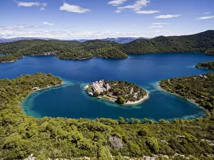
Govedari, Landscape, Nature, adriatic sea, aerial view, croatia, drone point of view, hdr, holiday, lifestyle, mljet, mljet national park, scenic, snorkelling, summer, swimming, tranquil scene

Background imageAerial View Collection: Aerial view of Saint Mary Island, Mljet National Park, Croatia

Aerial view of Saint Mary Island, Mljet National Park, Croatia
Veliko Jezero, Mljet Island, Croatia

Background imageAerial View Collection: North Las Vegas Nevada US City Street Map

North Las Vegas Nevada US City Street Map
Vector Illustration of a City Street Map of North Las Vegas, Nevada, USA. Scale 1:60, 000. All source data is in the public domain. U.S

Background imageAerial View Collection: Fort Collins Colorado US City Street Map

Fort Collins Colorado US City Street Map
Vector Illustration of a City Street Map of Fort Collins, Colorado, USA. Scale 1:60, 000. All source data is in the public domain. U.S

Background imageAerial View Collection: Aurora Colorado US City Street Map

Aurora Colorado US City Street Map
Vector Illustration of a City Street Map of Aurora, Colorado, USA. Scale 1:60, 000. All source data is in the public domain. U.S

Background imageAerial View Collection: Denver Colorado US City Street Map

Denver Colorado US City Street Map
Vector Illustration of a City Street Map of Denver, Colorado, USA. Scale 1:60, 000. All source data is in the public domain. U.S

Background imageAerial View Collection: Arvada Colorado US City Street Map

Arvada Colorado US City Street Map
Vector Illustration of a City Street Map of Arvada, Colorado, USA. Scale 1:60, 000. All source data is in the public domain. U.S

Background imageAerial View Collection: Santa Fe New Mexico US City Street Map

Santa Fe New Mexico US City Street Map
Vector Illustration of a City Street Map of Santa Fe, New Mexico, USA. Scale 1:60, 000. All source data is in the public domain. U.S

Background imageAerial View Collection: Rio Rancho New Mexico US City Street Map

Rio Rancho New Mexico US City Street Map
Vector Illustration of a City Street Map of Rio Rancho, New Mexico, USA. Scale 1:60, 000. All source data is in the public domain. U.S

Background imageAerial View Collection: Albuquerque New Mexico US City Street Map

Albuquerque New Mexico US City Street Map
Vector Illustration of a City Street Map of Albuquerque, New Mexico, USA. Scale 1:60, 000. All source data is in the public domain. U.S

Background imageAerial View Collection: Grand Forks North Dakota US City Street Map

Grand Forks North Dakota US City Street Map
Vector Illustration of a City Street Map of Grand Forks, North Dakota, USA. Scale 1:60, 000. All source data is in the public domain. U.S

Background imageAerial View Collection: Saint Paul Minnesota US City Street Map

Saint Paul Minnesota US City Street Map
Vector Illustration of a City Street Map of Saint Paul, Minnesota, USA. Scale 1:60, 000. All source data is in the public domain. U.S

Background imageAerial View Collection: Rochester Minnesota US City Street Map

Rochester Minnesota US City Street Map
Vector Illustration of a City Street Map of Rochester, Minnesota, USA. Scale 1:60, 000. All source data is in the public domain. U.S

Background imageAerial View Collection: Bloomington Minnesota US City Street Map

Bloomington Minnesota US City Street Map
Vector Illustration of a City Street Map of Bloomington, Minnesota, USA. Scale 1:60, 000. All source data is in the public domain. U.S

Background imageAerial View Collection: Rapid City South Dakota US City Street Map

Rapid City South Dakota US City Street Map
Vector Illustration of a City Street Map of Rapid City, South Dakota, USA. Scale 1:60, 000. All source data is in the public domain. U.S

Background imageAerial View Collection: Lincoln Nebraska US City Street Map

Lincoln Nebraska US City Street Map
Vector Illustration of a City Street Map of Lincoln, Nebraska, USA. Scale 1:60, 000. All source data is in the public domain. U.S

Background imageAerial View Collection: Aberdeen South Dakota US City Street Map

Aberdeen South Dakota US City Street Map
Vector Illustration of a City Street Map of Aberdeen, South Dakota, USA. Scale 1:60, 000. All source data is in the public domain. U.S

Background imageAerial View Collection: Watertown South Dakota US City Street Map

Watertown South Dakota US City Street Map
Vector Illustration of a City Street Map of Watertown, South Dakota, USA. Scale 1:60, 000. All source data is in the public domain. U.S

Background imageAerial View Collection: Sioux Falls South Dakota US City Street Map

Sioux Falls South Dakota US City Street Map
Vector Illustration of a City Street Map of Sioux Falls, South Dakota, USA. Scale 1:60, 000. All source data is in the public domain. U.S

Background imageAerial View Collection: Kansas City Missouri US City Street Map

Kansas City Missouri US City Street Map
Vector Illustration of a City Street Map of Kansas City, Missouri, USA. Scale 1:60, 000. All source data is in the public domain. U.S

Background imageAerial View Collection: Overland Park Kansas US City Street Map

Overland Park Kansas US City Street Map
Vector Illustration of a City Street Map of Overland Park, Kansas, USA. Scale 1:60, 000. All source data is in the public domain. U.S

Background imageAerial View Collection: Olathe Kansas US City Street Map

Olathe Kansas US City Street Map
Vector Illustration of a City Street Map of Olathe, Kansas, USA. Scale 1:60, 000. All source data is in the public domain. U.S

Background imageAerial View Collection: Independence Missouri US City Street Map

Independence Missouri US City Street Map
Vector Illustration of a City Street Map of Independence, Missouri, USA. Scale 1:60, 000. All source data is in the public domain. U.S

Background imageAerial View Collection: Wichita Kansas US City Street Map

Wichita Kansas US City Street Map
Vector Illustration of a City Street Map of Wichita, Kansas, USA. Scale 1:60, 000. All source data is in the public domain. U.S

Background imageAerial View Collection: Springfield Missouri US City Street Map

Springfield Missouri US City Street Map
Vector Illustration of a City Street Map of Springfield, Missouri, USA. Scale 1:60, 000. All source data is in the public domain. U.S

Background imageAerial View Collection: Topeka Kansas US City Street Map

Topeka Kansas US City Street Map
Vector Illustration of a City Street Map of Topeka, Kansas, USA. Scale 1:60, 000. All source data is in the public domain. U.S

Background imageAerial View Collection: Houston Texas US City Street Map

Houston Texas US City Street Map
Vector Illustration of a City Street Map of Houston, Texas, USA. Scale 1:60, 000. All source data is in the public domain. U.S

Background imageAerial View Collection: Broken Arrow Oklahoma US City Street Map

Broken Arrow Oklahoma US City Street Map
Vector Illustration of a City Street Map of Broken Arrow, Oklahoma, USA. Scale 1:60, 000. All source data is in the public domain. U.S

Background imageAerial View Collection: Tulsa Oklahoma US City Street Map

Tulsa Oklahoma US City Street Map
Vector Illustration of a City Street Map of Tulsa, Oklahoma, USA. Scale 1:60, 000. All source data is in the public domain. U.S

Background imageAerial View Collection: Norman Oklahoma US City Street Map

Norman Oklahoma US City Street Map
Vector Illustration of a City Street Map of Norman, Oklahoma, USA. Scale 1:60, 000. All source data is in the public domain. U.S

Background imageAerial View Collection: Corpus Christi Texas US City Street Map

Corpus Christi Texas US City Street Map
Vector Illustration of a City Street Map of Corpus Christi, Texas, USA. Scale 1:60, 000. All source data is in the public domain. U.S

Background imageAerial View Collection: Plano Texas US City Street Map

Plano Texas US City Street Map
Vector Illustration of a City Street Map of Plano, Texas, USA. Scale 1:60, 000. All source data is in the public domain. U.S

Background imageAerial View Collection: McAllen Texas US City Street Map

McAllen Texas US City Street Map
Vector Illustration of a City Street Map of McAllen, Texas, USA. Scale 1:60, 000. All source data is in the public domain. U.S

Background imageAerial View Collection: McKinney Texas US City Street Map

McKinney Texas US City Street Map
Vector Illustration of a City Street Map of McKinney, Texas, USA. Scale 1:60, 000. All source data is in the public domain. U.S

Background imageAerial View Collection: Lubbock Texas US City Street Map

Lubbock Texas US City Street Map
Vector Illustration of a City Street Map of Lubbock, Texas, USA. Scale 1:60, 000. All source data is in the public domain. U.S

Background imageAerial View Collection: Garland Texas US City Street Map

Garland Texas US City Street Map
Vector Illustration of a City Street Map of Garland, Texas, USA. Scale 1:60, 000. All source data is in the public domain. U.S


All Professionally Made to Order for Quick Shipping