mail_outline sales@mediastorehouse.com
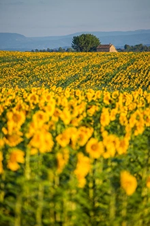
Sunflower Fields in Valensole, FranceValensole is a part of Provence. The sunflower and other flower bloom in summer season every year
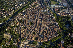
City centre, Montelimar, Rhone-Alpes, France
Prima Ballerina Russian Ballet Dancer Anna Pavlova1924: Russian Ballet dancer Anna Pavlova (1882 - 1931), regarded as the prima ballerina of her era. (Photo by James Abbe/General Photographic Agency/Getty Images)
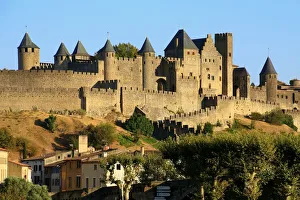
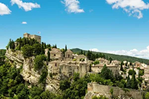
View of Carcassonne, France (Unesco world heritage)
Parisian Lovers23rd June 1951: A young couple sharing an intimate moment in one of the pavement cafes on the Champs-Elysees, Paris. Original Publication
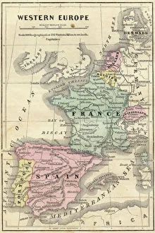
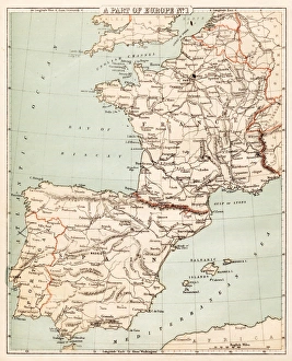
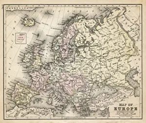
France Spain Portugal map 1856Colton and Fitchs Modern School Geography by George W. Fitch - New York 1856
Stained Glass of Sainte-ChapelleTonnaja Travel Photography, 515023137
Senanque Sabbey Landscape with its lavender field, ProvenceFamous Senanque abbey in Vaucluse with its lavender field in full bloom. Gordes, Provence, France
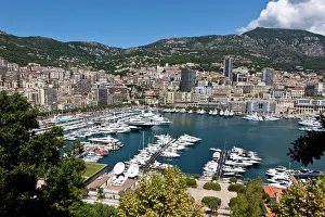
Overlooking the harbour of Monaco, Port Hercule, Monte Carlo, Principality of Monaco, Cote dAzur, Mediterranean Sea, Europe, PublicGround
Tour De France, August 195118th August 1951: A group of contestants racing in the Tour de France. Original Publication: Picture Post - 5381 - The Greatest Show On Earth - pub
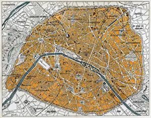
City map of Paris, lithograph, published in 1877City map of Paris, France. Lithograph, published in 1877
The Hunchback of Notre Dame engraving 1888The Hunchback of Notre Dame
Colmar in the evening, FrancePicturesque view of Petite Venise in the evening in Colmar, charming town in the Alsace region of France
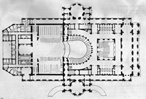
Opera House Plancirca 1865: A floor plan of the Paris Opera house. The building was designed by architect Charles Garnier and opened in 1875
Gargoyle of the Notre Dame Cathedral, Paris, FranceThe gargoyles are an essential part of the history of the cathedral, and a key aspect of the site. The gargoyles main purpose is very practical
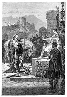
Vercingetorix surrendering to Julius CaesarIllustration of a Vercingetorix surrendering to Julius Caesar
Map of Spain and France 1869Cornells Grammars-School Geography - S.S. Cornell - New York D. Appleton and Company 1869
The reflection of Lac BlancTonnaja Travel Photography, 509094391
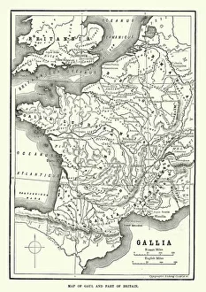
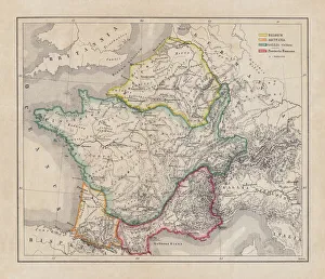
Map of Ancient Gaul (France)Vintage engraving of a Map of Ancient Gaul (France)
City map of ParisAntique illustration of a City map of Paris
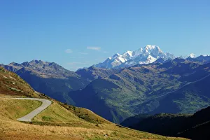
The pass road leading up to Col de la Madeleine, the snow-capped peaks of the Mont Blanc Massif at the back, Alps, France
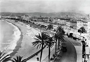
Nice RivieraThe Nice riviera, in southern France, April 1922. The seafront at the little town of Nice became known as " La Promenade des Anglais"
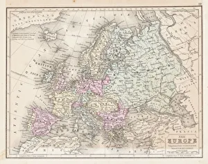
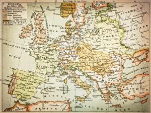
Europe map 1867Mitchellas Modern Atlas - Published by E.H. Butler and Co - Philadelphia 1867
Old Bridge Over the Gave River, The Cirque Of Gavarnie, Hautes Pyrenees, France
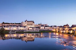
The walled town and Chateau of Amboise reflected in the River Loire in the evening, Amboise, Centre, France
Old town, Vaison-la-Romaine, Vaucluse, Provence-Alpes-Cote dAzur, France
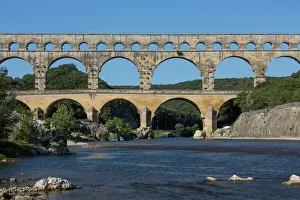
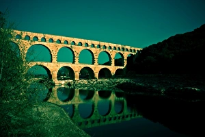
Pont du Gard - South of FrancePont du Gard Roman Aquaduct over the Gardon River near Remoulins in the South of France
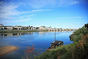
France SaumurFrance, Loire Valley, Saumur, River Loire, UNESCO World Heritage
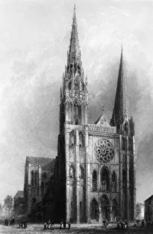
Chartres Cathedralcirca 1850: The cathedral church of Notre Dame at Chartres in north western France, famed for its medieval glass windows. (Photo by Hulton Archive/Getty Images)
Gaul in the time of Julius Caesar, published in 1867Gaul in the time of Roman politican Gaius Iulius Caesar (100 - 44 BC). Steel engraving with hand-colored borderlines and Latin legend, published in 1867
The Basilique Notre-Dame de la GardeNotre-Dame de la Garde is a Catholic basilica in Marseille, France. The fort was located at the highest natural elevation in Marseille limestone outcrop on the south side of the Old Port of
Illustration of Chateau de Mercues, Mercues, Lot, France
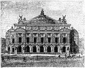
Garnier Opera House, ParisAntique illustration of a Garnier Opera House, Paris
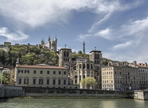
Fourviere Basilica from Saone river - LyonSt Jean district with its Fourviere basilica - Lyon France
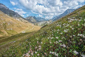
View of the Col du Galibier mountain pass, Savoie, France
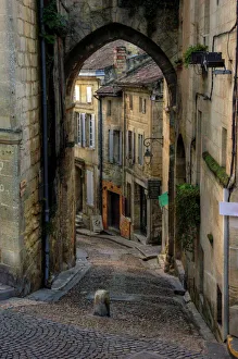
Saint Emilion village old cobbled narrow street
old map of european old map form 1883, showing european countries
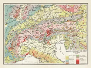
Geological map of the European Alps, lithograph, published in 1897Geological map of the European Alps. Lithograph, published in 1897
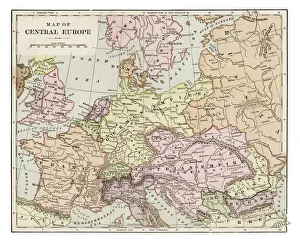
Map of central Europe 1889Indiana Educational Series The Complete Geography - Indianapolis 1889
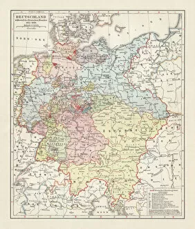
Map of the German Confederation (1815-1866), lithograph, published in 1897Map of the German Confederation between 1815 and 1866. Lithograph, published in 1897
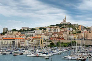
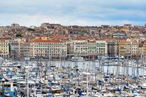
Old Port of MarseilleThe Old Port of Marseille is located at the end of the Canebiere. It has been the natural harbour of Marseille since antiquity and is now the main popular place in Marseille
Map of Europe 1721
Pont du GardRoman aqueduct
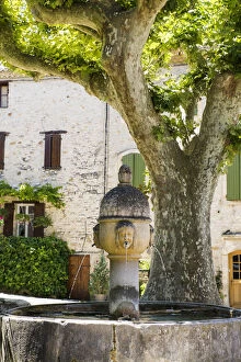
Medieval fountain, Vaison-La-Romaine, Vaucluse, Provence-Alpes-Cote dAzur, Provence, France
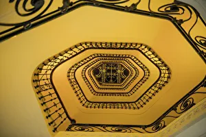
Low Angle View Of Spiral Staircase in Cannes, France
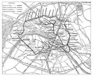
Antique engraving illustration: Paris Subway Metro map
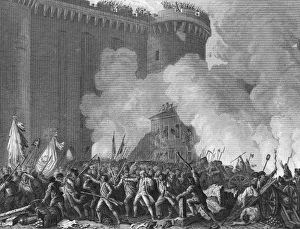
Bastille Attack In French RevolutionEngraving depicting the mass attack on the Bastille fortress, igniting the French Revolution, Paris, France, July 14, 1789. (Kean Collection/Getty Images)
Quillin TwilightTwilight descends over Quillin, a French village in the Cather Region of France