mail_outline sales@mediastorehouse.com
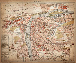
PragueAntique map of Prague from 1898
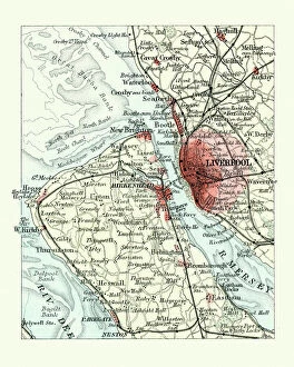
Antique map, Liverpool and Birkenhead, England, 19th CenturyVintage engraving of a Antique map, Liverpool and Birkenhead, England, 19th Century
St Thomas HospitalAugust 1919: St Thomas Hospital on the south bank of the River Thames, London. (Photo by Topical Press Agency/Getty Images)
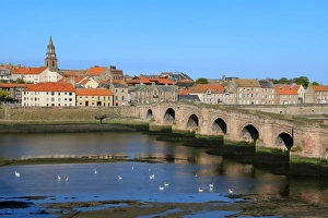
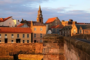
View of Berwick-upon-Tweed, EnglandBerwick-upon-Tweed is a town in the county of Northumberland. It is the northernmost town in England. It is located 2 1aua2 miles (4 km) south of the Scottish border
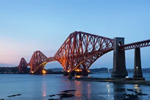
The Mighty Forth Rail Bridge at duskThe Forth Bridge over the Firth of Forth taken from South Queensferry. The Bridge is a UNESCO World Heritage Site
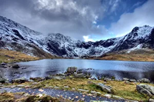
Llyn Idwal Lake, Snowdonia National ParkLlyn Idwal and Devils Kitchen in winter, Snowdonia National Park North Wales. Llyn Idwal is a small lake that lies within Cwm Idwal in the Glyderau mountains of Snowdonia
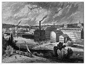
Industrial Revolution in the 1800s - scanned 1878 engraving
sky, skyline, memorial, wtc, 911, floodlight, lights, celebration, illuminated, skyscraper, waterfront, lower manhattan, twin towers, world trade center, glow, buildings, september 2011
Highly detailed USA Road MapHighly detailed map of United States with roads, states, big cities, rivers and some other objects
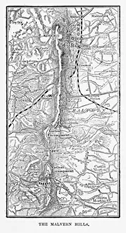
Map of Malvern Hills in Worcestershire, England Victorian Engraving, 1840Very Rare, Beautifully Illustrated Antique Engraving of Map of Malvern Hills in Worcestershire, England Victorian Engraving, 1840. Source: Original edition from my own archives
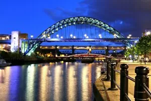
Late evening at the bridges over the River Tyne, Newcastle upon Tyne, EnglandThe three bridges are (from foreground to the back) : the Tyne bridge, The Swing bridge and the high level bridge. Gateshead is to the left and Newcastle to the right
Berwick-upon-Tweed (England) in the evening sunBerwick-upon-Tweed is a town in the county of Northumberland. It is the northernmost town in England. It is located 2 1aua2 miles (4 km) south of the Scottish border
Sunset at Smith Rock State Park in Oregon with view of Crooked River. This tremendously beautiful, and enormously popular
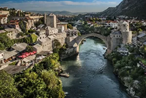
Mostar old bridge, Bosnia and Herzegovina
Illustration of four priests carrying the Ark of the Covenant and crossing the River Jordan
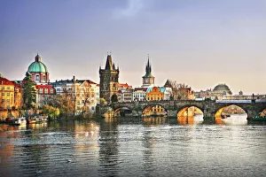
Prague Bridge over the Vltava RiverCharles Bridge is the oldest bridge still standing over the Vltava river in Prague. Charles IV had it built in 1357, after the previous bridge (“Judith Bridge”) had been destroyed by floods in 1342
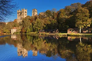
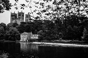
Durham Cathedral (Church of Christ, Blessed Mary the Virgin and St Cuthbert of Durham)The Cathedral Church of Christ, Blessed Mary the Virgin and St Cuthbert of Durham, usually known as Durham Cathedral and home of the Shrine of St Cuthbert, is a cathedral in the city of Durham
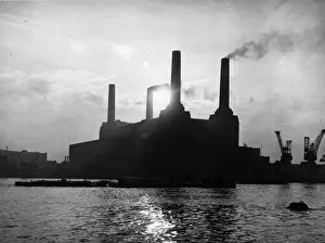
Battersea Power Station Silhouette25th January 1954: Battersea power station in London. With dimensions of 160m x 170m, the roof of the boiler house 50m tall, and its four 103m tall, tapering chimneys
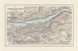
Historical city map of Heidelberg, Baden-WAOErttemberg, Germany, lithograph, published 1897Historical city map of Heidelberg, Baden-WAOErttemberg, Germany. Lithograph, published in 1897
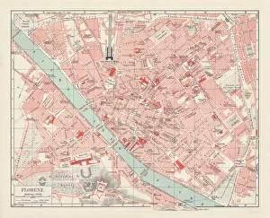
City map of Florence, Italy, lithograph, published in 1897City map of Florence - capital city of the Italian region of Tuscany. Lithograph, published in 1897
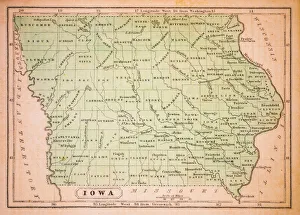
Iowa 1852 Map
The Narrows, Zion Canyon National Park, USAFamous hike in the Narrows, Virgin river, Zion Canyon National Park, Utah, USA
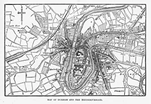
DurhamWe see The Norman Cathedral on this images in Durham is a historic city and the county town of County Durham in North East England
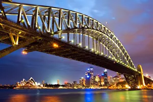
Sydney Harbour bridgeView of Sydney Harbour bridge with Opera House and skyline in background at night, Sydney, NSW, Australia
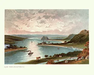
The River Clyde from Dalnotter Hill, Scotland, 19th CenturyVintage colour engraving of The River Clyde from Dalnotter Hill, Scotland, 19th Century
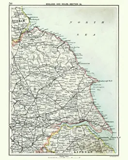
Antique map, North and East Yorkshire 19th CenturyVintage engraving of a Antique map, North and East Yorkshire 19th Century
City map of Paris, lithograph, published in 1877City map of Paris, France. Lithograph, published in 1877
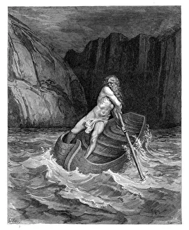
Charon the ferryman engravingCharon the ferryman of Hell engraving by Gustave Dore
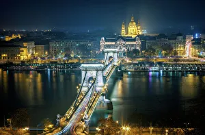
Budapest - Chain Bridge by NightThe Chain Bridge stands out against the night sky in Budapest
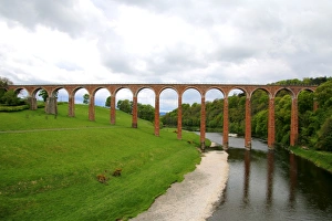
The nineteenth century arched Leaderfoot Viaduct over the River Tweed in the Scottish Borders, ScotlandLeaderfoot Viaduct is a disused railway viaduct over the River Tweed near Melrose in the Scottish Borders, Scotland. The viaduct was completed in 1863
Colmar in the evening, FrancePicturesque view of Petite Venise in the evening in Colmar, charming town in the Alsace region of France
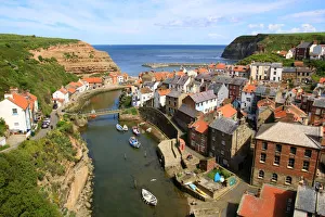
An elevated view of the fishing village of Staithes, North Yorkshire, EnglandLooking seawards over cottage rooftops of the fishing village of Staithes, North Yorkshire, England
Victoria Falls, Livingstone, ZambiaKnown locally as Mosi-oa-Tunya, the " smoke that thunders", the falls are situated on the Zambezi River, on the border between Zambia and Zimbabwe
Zambezi River view with the spray from Victoria Falls in the distance. Livingstone. Zambia
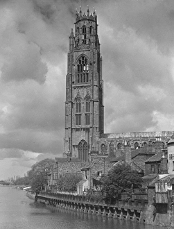
Boston Stump and River Welland, Lincolnshire, circa 1930. (Photo by Herbert Felton/Hulton Archive/Getty Images)
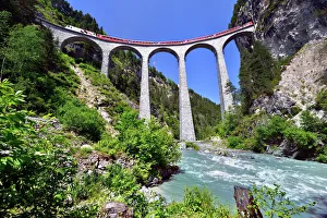
A train of the Rhaetian Railway on the Landwasser Viaduct, UNESCO World Heritage Site, near Filisur, Canton of Grisons, Switzerland
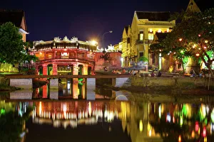
View to Japanese Covered Bridge, Hoi An, VietnamJapanese Bridge at night, Hoi An, UNESCO World Heritage Site, Vietnam
Stand To Attention29th September 1931: Peter, the mongrel dog of Tower View in London begging on a jetty near Tower Bridge. (Photo by Fox Photos/Getty Images)
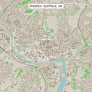
Ipswich Suffolk UK City Street MapVector Illustration of a City Street Map of Ipswich, Suffolk, UK. Included files are EPS (v10) and Hi-Res JPG. Data courtesy from Ordnance Survey: VectorMap District https
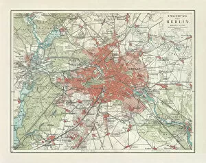
City map of Berlin and surrounding, Germany, lithograph, published 1897City map of Berlin and surrounding, capital of Germany. Lithograph, published in 1897
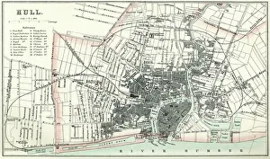
Map of HullVintage map from 1880 of Hull in the East Riding of Yorkshire, England. The city of Hull has served as market town, military supply port, trading hub, fishing and whaling centre
Map of the City of Durham, England Victorian Engraving, 1840Very Rare, Beautifully Illustrated Antique Engraving of Map of the City of Durham, England Victorian Engraving, 1840. Source: Original edition from my own archives
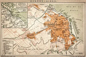
Buenos Aires mapAntique engraving map of Buenos Aires
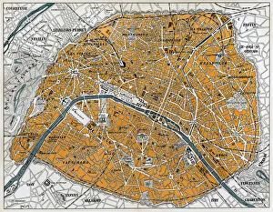
City map of ParisAntique illustration of a City map of Paris
Dream Falls - Tahquamenon Falls State ParkUpper Tahquamenon Falls in Fall Color. Tahquamenon Falls State Park encompasses close to 50, 000 acres stretching over 13 miles
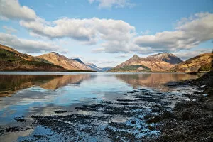
Pap of Glencoe (Scottish Gaelic: Sgurr na C?che) mountain on northern side of Glen Coe, in Highlands of Scotland
Hoi An ancient town at nightHoi An ancient town is famous spot in Quang Nam province, Vietnam. Hoian is recognized as a World Heritage Site by UNESCO
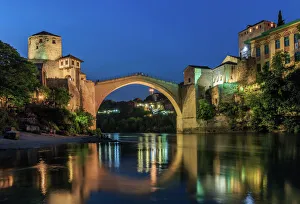
Mostar, the Old Bidge over the Neretva river, Bosnia and HerzegovinaOld Bridge (Stari Most) reflected in Neretva River, Bosnia and Hercegovina, at dusk, long exposure. The bridge is a famous tourist destination