mail_outline sales@mediastorehouse.com
Bamberg Old Town Hall at night. Bamberg, Bavaria, Germany
View of Tbilisi (Georgia) at duskView of Old Town and Narikala Fortress at dusk in Tbilisi, Republic of Georgia
Franz Josef Glacier - Panorama View at Sunset
A boat station at Perfume River (Huong river) near Thien Mu pagoda, Hue, VietnamHue is old capital of Vietnam and a UNESCO World Heritage site
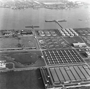
Sewage WorksCrossness Sewage works which belong to the Greater London Council
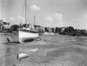
Chiswick MallLow tide at Chiswick Mall, an area of Chiswick in west London, on the banks of the River Thames, circa 1930. (Photo by Herbert Felton/Hulton Archive/Getty Images)
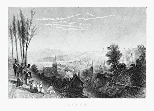
View of Liege, Belgium Circa 1887Beautifully Illustrated Antique Engraved Victorian Illustration of View of Liege, Belgium Circa 1887. Source: Original edition from my own archives. Copyright has expired on this artwork
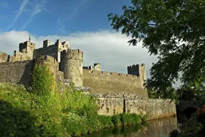
tradition, clouds, sky, county, travel, fortress, landmark, protection, defense, ancient, architecture, daytime, outdoors, Irish, history, river, nobody, wall, Cahir Castle, Tipperary
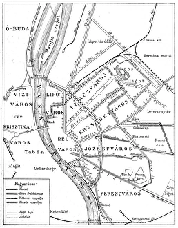
Budapest city mapIllustration of a Budapest city map
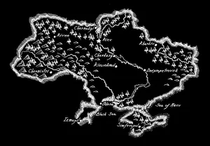
Antique Ukraine MapUkraine Map, - Antique style. Includes mountains and water bodies. High detail - vector illustration
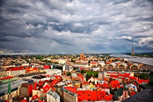
Cityscape of RigaCapital City of Riga, Latvia in Eastern Europe after rain storm with rainbow in sky
Hiker at Dettifoss Waterfall, Joekulsargljufur, Iceland, Europe
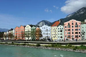
Houses on the river, district of Mariahilf, Innsbruck, Tyrol, Austria, Europe, PublicGround
Poplars, the Chilean Andes at the back, on the Rio Chacabuco river, Cochrane, Region de Aysen, Patagonia, Chile, South America, America
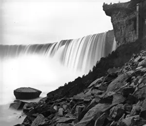
Table Rock1859: The spiral staircase leading down from Table Rock, on the Canadian side of Niagara Falls. The Canadian or Horseshoe Falls cascade down to the left
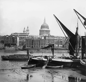
Southwark View1859: St Pauls Cathedral as seen from Southwark, across the River Thames. (Photo by William England/London Stereoscopic Company/Getty Images)
Colorful night light at Galata Bridge
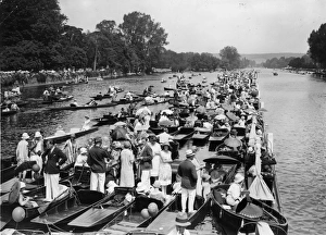
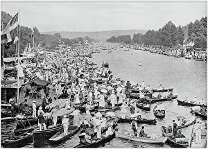
Regatta Crowds30th June 1926: Large crowds gathered on the river at Henley for the first day of the Regatta, the rowing boats full of spectators are pushed up against a boom which defines the racing area of
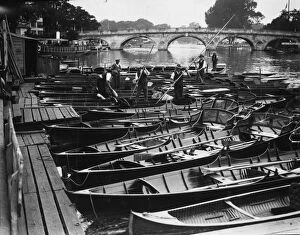
Henley Boats29th June 1926: Punts and rowing boats on the River Thames at Henley. (Photo by H. F. Davis/Topical Press Agency/Getty Images)
Mont Saint-Michel (France)Mont Saint-Michel ( English: Saint Michaels Mount) is an island commune in Normandy, France. One of Frances most recognisable landmarks
mt. Everest from Everest Base Camp, Tibet
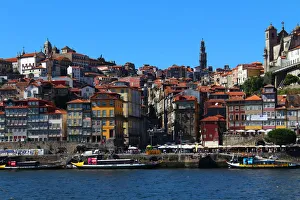
Ribeira district in Porto
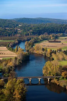
Dordogne River ValleyFrance, Aquitaine Region, Dordogne Department, Domme, elevated view of the Dordogne River Valley from the Belvedere de la Barre
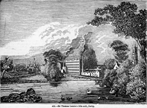
Silk MillThomas Lombes silk mill in Derby, circa 1720. (Photo by Hulton Archive/Getty Images)
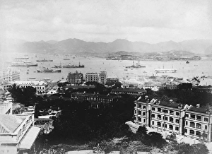
Hong Kong HarbourHong Kong harbour, looking towards Kowloon, circa 1910. (Photo by Hulton Archive/Getty Images)
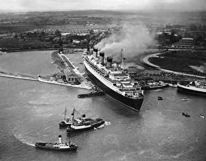
Queen Mary27th March 1936: The Cunard liner Queen Mary, arriving at Southampton for the first time. (Photo by Rapho Guillumette/Fox Photos/Getty Images)
Antique Finland MapFinland Map, - Antique style. Includes mountains and water bodies. High detail - vector illustration
New York Skyline Reflection
Antique black and white photograph of England and Wales: Henley Regatta
La Fontaines Fables - Torrent and the RiverVintage engraving from La Fontaines Fables, Illustraed by Gustave Dore. The Torrent and the River. A Horse and rider try to cross a flooded river ford
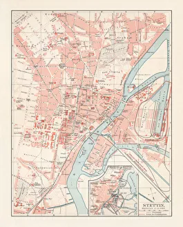
City map of Stettin, Germany (today Szczecin, Poland), lithograph, 1897Historical city map of Stettin, Germany (today Szczecin, Poland). Lithograph, published in 1897
Chelsea Bridge spanning the River Thames4th February 1947: Chelsea Bridge spanning the River Thames in London. Battersea Power station can be glimpsed in the background
Ancient egyptians hunting birdsVintage engraving of Ancient egyptians hunting birds
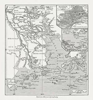
Historical map of the Pearl River Delta, woodcut, published 1897Historical map of the mouth of the Pearl River Delta (Zhujiang) with the locations of Guangzhou (Canton), Macau and Hong Kong at the end of the 19th century. Wood engraving, published in 1897
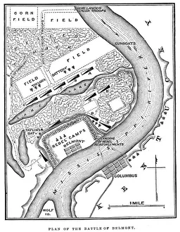
Battle of BelmontVintage engraving from 1863 of a map of the Battle of Belmont which was fought on November 7, 1861, in Mississippi County, Missouri. It was the first combat test in the American Civil War for Brig
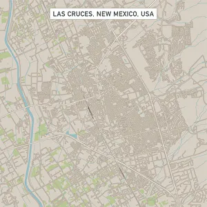
Las Cruces New Mexico US City Street MapVector Illustration of a City Street Map of Las Cruces, New Mexico, USA. Scale 1:60, 000. All source data is in the public domain. U.S
Roswell New Mexico US City Street MapVector Illustration of a City Street Map of Roswell, New Mexico, USA. Scale 1:60, 000. All source data is in the public domain. U.S
Westminster Colorado US City Street MapVector Illustration of a City Street Map of Westminster, Colorado, USA. Scale 1:60, 000. All source data is in the public domain. U.S
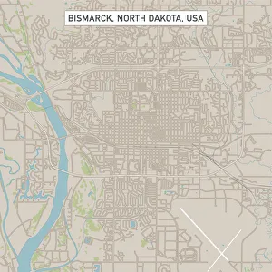
Bismarck North Dakota US City Street MapVector Illustration of a City Street Map of Bismarck, North Dakota, USA. Scale 1:60, 000. All source data is in the public domain. U.S
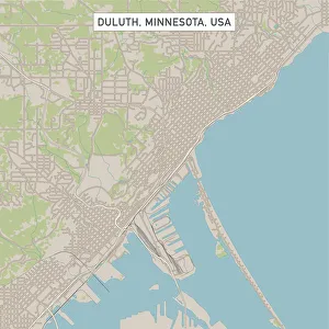
Duluth Minnesota US City Street MapVector Illustration of a City Street Map of Duluth, Minnesota, USA. Scale 1:60, 000. All source data is in the public domain. U.S
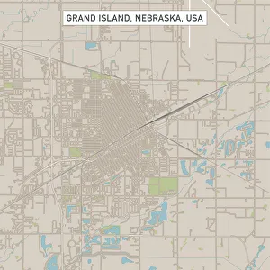
Grand Island Nebraska US City Street MapVector Illustration of a City Street Map of Grand Island, Nebraska, USA. Scale 1:60, 000. All source data is in the public domain. U.S
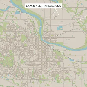
Lawrence Kansas US City Street MapVector Illustration of a City Street Map of Lawrence, Kansas, USA. Scale 1:60, 000. All source data is in the public domain. U.S
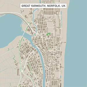
Great Yarmouth Norfolk UK City Street MapVector Illustration of a City Street Map of Great Yarmouth, Norfolk, UK. Included files are EPS (v10) and Hi-Res JPG. Data courtesy from Ordnance Survey: VectorMap District https
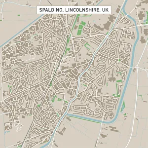
Spalding Lincolnshire UK City Street MapVector Illustration of a City Street Map of Spalding, Lincolnshire, UK. Included files are EPS (v10) and Hi-Res JPG. Data courtesy from Ordnance Survey: VectorMap District https
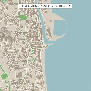
Gorleston-on-Sea Norfolk UK City Street MapVector Illustration of a City Street Map of Gorleston-on-Sea, Norfolk, UK. Included files are EPS (v10) and Hi-Res JPG. Data courtesy from Ordnance Survey: VectorMap District https
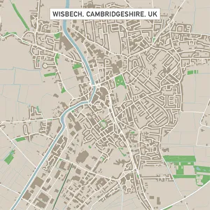
Wisbech Cambridgeshire UK City Street MapVector Illustration of a City Street Map of Wisbech, Cambridgeshire, UK. Included files are EPS (v10) and Hi-Res JPG. Data courtesy from Ordnance Survey: VectorMap District https