mail_outline sales@mediastorehouse.com
Football pitch drawn on a chalkboard
Sweet Cicely -Myrrhis odorata-, Europe
Origami cyclebicycle folded out of paper, origami style
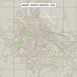
Minot North Dakota US City Street MapVector Illustration of a City Street Map of Minot, North Dakota, USA. Scale 1:60, 000. All source data is in the public domain. U.S
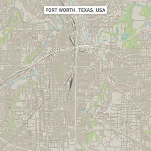
Fort Worth Texas US City Street MapVector Illustration of a City Street Map of Fort Worth, Texas, USA. Scale 1:60, 000. All source data is in the public domain. U.S
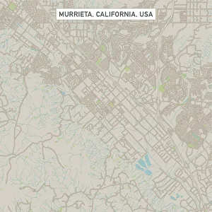
Murrieta California US City Street MapVector Illustration of a City Street Map of Murrieta, California, USA. Scale 1:60, 000. All source data is in the public domain. U.S
Tick engraving 1878Encyclopedia Britannica 9th Edition Vol II New York, Samuel Hall 1878
Blue and white fishing trawler, side view
White cat, portrait
Cyclamen -Cyclamen cilicium- in white and red lines in a flower bed
Labradoodle, adult, male, on meadow, Germany
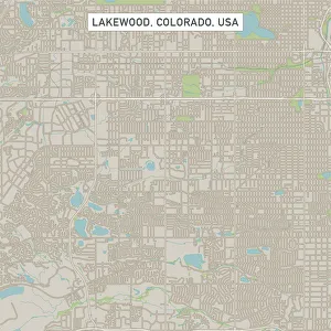
Lakewood Colorado US City Street MapVector Illustration of a City Street Map of Lakewood, Colorado, USA. Scale 1:60, 000. All source data is in the public domain. U.S
Austin Texas US City Street MapVector Illustration of a City Street Map of Austin, Texas, USA. Scale 1:60, 000. All source data is in the public domain. U.S
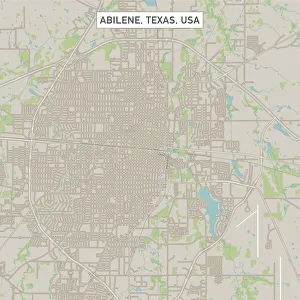
Abilene Texas US City Street MapVector Illustration of a City Street Map of Abilene, Texas, USA. Scale 1:60, 000. All source data is in the public domain. U.S
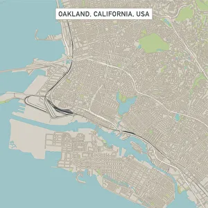
Oakland California US City Street MapVector Illustration of a City Street Map of Oakland, California, USA. Scale 1:60, 000. All source data is in the public domain. U.S
Irvine California US City Street MapVector Illustration of a City Street Map of Irvine, California, USA. Scale 1:60, 000. All source data is in the public domain. U.S
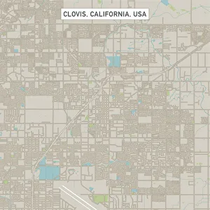
Clovis California US City Street MapVector Illustration of a City Street Map of Clovis, California, USA. Scale 1:60, 000. All source data is in the public domain. U.S
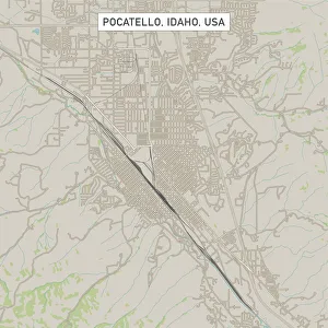
Pocatello Idaho US City Street MapVector Illustration of a City Street Map of Pocatello, Idaho, USA. Scale 1:60, 000. All source data is in the public domain. U.S
Parsnip (Pastinaca sativa)Parsnip, vintage engraved illustration
Tamworth pigIllustration of a Tamworth pig
Le Shuttle train, front view
Bruennichs guillemot (Uria lomvia), two birds perching on a rock, looking away
Traditional Greek houses in Naxos, Greece
Bell tower in Oia village, Santorini, GreeceGreek church bell tower of Panagia Platsani, Oia, Santorini (Thira), Cyclades Islands, Greek Islands, Greece
Cafe Au LaitDahlia flow Cafe Au Lait
At sign on a computer keyboard, symbolic image for the internet
Church of Santa Maria del Soccorso, Forio, Ischia, Italy
High mountain peaks of Chamonix
mt. Everest from Everest Base Camp, Tibet, China
Trakehner black stallion
Eurasian Magpie / European Magpie / Common Magpie, standing on a branch. Spain, EuropeNature reserve of the saw Mariola in Bocairent, Valencian Community, Spain
Snowy Owl, Arctic Owl, Great White Owl, Harfang (Bubo scandiacus) (Nyctea scandiaca), calling
Mount Fuji on cloudsI took this picture in Fujinomiya city with a telephoto lens
Electricity machine by PixiiAn early form of an alternating current electrical generator built by Pixii in 1832
German Reichsbank in Berlin, GermanyAntique illustration of a German Reichsbank in Berlin, Germany
Golden Retriever -Canis lupus familiaris- puppy, three months, running across a meadow
mt. Everest from Everest Base Camp, Tibet
Brazil, Parana, Iguassu Falls National Park (Cataratas do Iguacu) (UNESCO Site), Devils Throat (Garganta do Diabo)
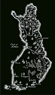
Antique Finland MapFinland Map, - Antique style. Includes mountains and water bodies. High detail - vector illustration
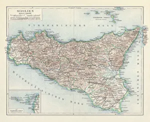
Topographic map of Sicily, Italy, lithograph, published in 1897Topographic map of Sicily, Italy - largest island in the Mediterranean Sea. Lithograph, published in 1897
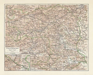
Topographic map of Styria, Austria, lithograph, published in 1897Topographic map of Styria - state (Bundesland) located in the southeast of Austria. Lithograph, published in 1897
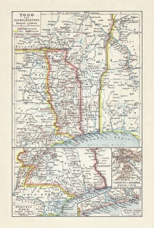
Historical map of Togo during the German colonial period (1884-1916)Historical map of Togo in West Africa during the German colonial period from 1884 to 1916. Lithograph, published in 1897
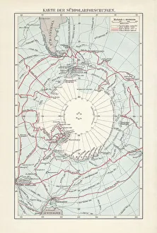
Antarctica map with sea routes of various explorers, lithograph, 1897Historical map of the unexplored Antarctica with sea routes of various explorers, 18th - 19th century. Lithograph, published in 1897
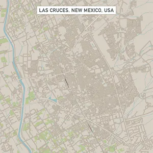
Las Cruces New Mexico US City Street MapVector Illustration of a City Street Map of Las Cruces, New Mexico, USA. Scale 1:60, 000. All source data is in the public domain. U.S