mail_outline sales@mediastorehouse.com
Choose a picture from our Images Dated 14th April 2018 Collection for your Wall Art and Photo Gifts
17 items
Aerial of lower Manhattan at sunset, New York, USAAerial of lower Manhattan skyline at sunset, New York, USA
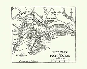
Map of Kingston and Port Royal, Jamaica, 19th CenturyVintage engraving of a Map of Kingston and Port Royal, Jamaica, 19th Century
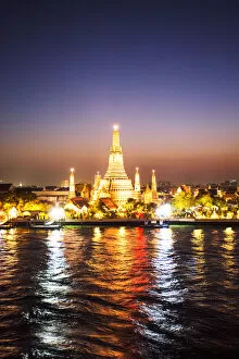
Thailand, Bangkok. Wat Arun (temple of dawn) at dusk
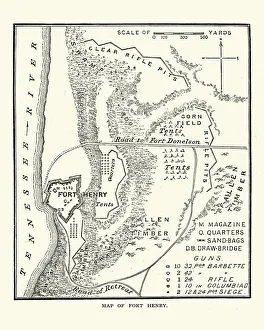
American Civil War, Map of Fort Henry, TennesseeVintage engraving of a scene from the American Civil War, Battle of Fort Henry, fought on February 6, 1862, in western Middle Tennessee, during the American Civil War
Aerial view of Bora Bora island and blue lagoonAerial view of Bora Bora island with Mt Otemanu and blue lagoon. Bora Bora, Society Islands, French Polynesia, Pacific Islands
Peregrine Falcon Fluffing His Feathers at Sunrise on Long IslandA cute Peregrine Falcon perched on branch and shaking his feathers out at sunrise on Jones Beach, Long Island
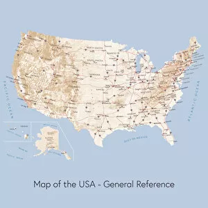
Map of the USA general referenceVector illustration of a map of the United States of America. The reference map used in the creation of this illustration is public domain map available at the University of Texas website: http
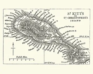
Map of Saint Kitts, 19th CenturyVintage engraving of a Map of Saint Kitts, 19th Century. Saint Kitts and Nevis, also known as the Federation of Saint Christopher and Nevis, [4] is an island country in the West Indies
Notre Dame cathedral at dusk, Paris, FranceParis, Ile de France, France
Giant californian coast redwoods forest, Rotorua, New ZealandRedwood forest, Rotorua, New Zealand
Agalychnis callidryas, Leaf, Nature, Night, Outdoors, Red, Travel Destinations, Tree, america, amphibian, animal, animal themes, animals in the wild, arboreal, arenal volcano national park
Manhattan bridge structure framing the Empire State buildingThe Manhattan suspension Bridge crosses the East River in New York City, connecting Lower Manhattan at Canal Street with Downtown Brooklyn at the Flatbush Avenue Extension
Cable car in California street, San Francisco, USAIconic cable car in California street, San Francisco, California, USA
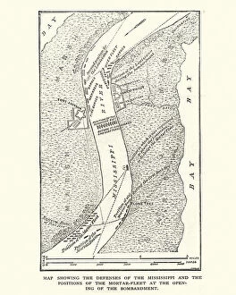
American Civil War, Map of Defenses of River MississippiVintage engraving of a American Civil War, Map of Defenses of River Mississippi
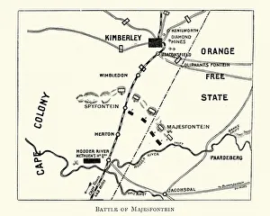
Plan of the Battle of MagersfonteinVintage engraving of a Plan of the Battle of Magersfontein, fought on 11 December 1899, at Magersfontein near Kimberley on the borders of the Cape Colony
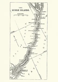
Map of Kuril Islands, 19th CenturyVintage engraving of a Map of Kuril Islands, 19th Century. The Kuril Islands or Kurile Islands in Russias Sakhalin Oblast region, form a volcanic archipelago that stretches approximately 1, 300 km
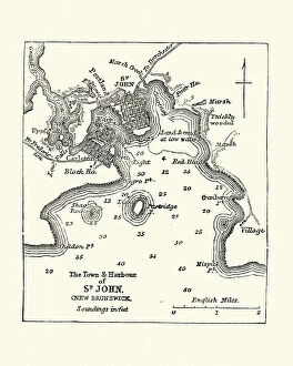
Map of Saint John, New Brunswick, Canada 19th CenturyVintage engraving of Map of Saint John, New Brunswick, 19th Century, 19th Century. 1878