
Home > Map > Map Illustrations

Asia Map - illustration

Asia Map - illustration


Cards
Home Decor
Mounted Prints
Canvas Prints
Fine Art Prints
Metal Prints


We accept all major credit cards

Wall Art and Photo Gifts from Fine Art Storehouse

Asia Map - illustration

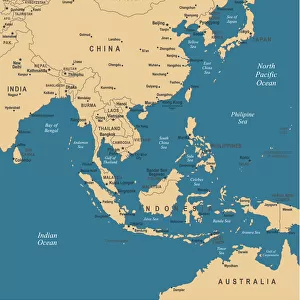
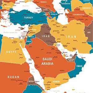
Colored Map of Asia with Country Names and Capital Cities The url of the reference to map is: http:/lib.utexas.edu/maps/world_maps/time_zones_ref_2011.pdf. In addition - some city locations were taken from: http:/lib.utexas.edu/maps/world_maps/txu-oclc-264266980-world_pol_2008-2.jpg. The illustration completed August 14, 2015 and created in Corel Draw 1 layer of data used for the detailed outline of the land

Media ID 14777521


MADE IN THE UK
Safe Shipping with 30 Day Money Back Guarantee

FREE PERSONALISATION*
We are proud to offer a range of customisation features including Personalised Captions, Color Filters and Picture Zoom Tools

SECURE PAYMENTS
We happily accept a wide range of payment options so you can pay for the things you need in the way that is most convenient for you

* Options may vary by product and licensing agreement. Zoomed Pictures can be adjusted in the Basket.


redeem
Beautiful Photo Prints and Gifts
image
Professionally Printed
inventory
Photo Prints are in stock
thumb_up
Professional quality finish
diamond
Made with high-grade materials
inventory_2
Carefully packed to aid safe arrival


Related Images


Map of Middle East - illustration
East Asia Map
East Asia Map
Political map of South East Asia
South America 1852 Map
Colored Map of Middle East
South America map countries and cities
Detailed map of Europe
political map of south america in vector format
South America Cartoon Map
Australia and pacific islands map 1898
Map of South America 1895
Physical map of South America

+

Shipping

+

Choices

+

Guaranteed