Home > Map > USA Maps
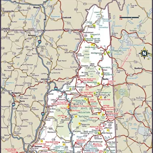
Antique map of New Hampshire USA 19th century 1819

![]()
Wall Art and Photo Gifts from Fine Art Storehouse
Antique map of New Hampshire USA 19th century 1819
This is a copperplate engraving, a 19th century map of New Hampshire in the United States of America, with hand-coloured borders with Canada, Maine, Massachusetts and Vermont. Captions: 72 Longitude West from London 71. New Hampshire. 3 Longitude East from Philadelphia 4. The map is from Arrowsmith & Lewis, published by John Conrad & Co. and is from A New and Elegant General Atlas published in 1819. The map shows topography, towns, townships, counties and roads
Whiteway
Media ID 15387389
© Whiteway
Copper Engraving Isolated New Hampshire The Americas
FEATURES IN THESE COLLECTIONS
> Map
> Historical Maps
> Map
> Photo Libraries
> The Illustrated London News (ILN)
MADE IN THE UK
Safe Shipping with 30 Day Money Back Guarantee
FREE PERSONALISATION*
We are proud to offer a range of customisation features including Personalised Captions, Color Filters and Picture Zoom Tools
SECURE PAYMENTS
We happily accept a wide range of payment options so you can pay for the things you need in the way that is most convenient for you
* Options may vary by product and licensing agreement. Zoomed Pictures can be adjusted in the Basket.