Home > Map > Historical Maps
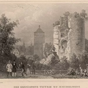
Historical city map of Heidelberg, Baden-WAOErttemberg, Germany, lithograph, published 1897

![]()
Wall Art and Photo Gifts from Fine Art Storehouse
Historical city map of Heidelberg, Baden-WAOErttemberg, Germany, lithograph, published 1897
Historical city map of Heidelberg, Baden-WAOErttemberg, Germany. Lithograph, published in 1897
Media ID 15372237
© This content is subject to copyright
Baden Wurttemberg Brown City Map Downtown District European Culture German Culture Heidelberg Konigsstuhl Neckar Neckar River Sights Topographic Map
FEATURES IN THESE COLLECTIONS
> Map
> Historical Maps
> Map
MADE IN THE UK
Safe Shipping with 30 Day Money Back Guarantee
FREE PERSONALISATION*
We are proud to offer a range of customisation features including Personalised Captions, Color Filters and Picture Zoom Tools
SECURE PAYMENTS
We happily accept a wide range of payment options so you can pay for the things you need in the way that is most convenient for you
* Options may vary by product and licensing agreement. Zoomed Pictures can be adjusted in the Basket.