Home > Map > Historical Maps
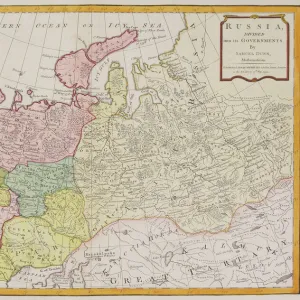
Map of the Russian Empire in Europe and Asia 1780

![]()
Wall Art and Photo Gifts from Fine Art Storehouse
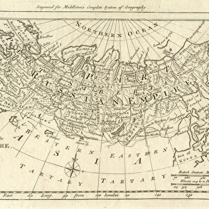
Map of the Russian Empire in Europe and Asia 1780
This is a map of the Russian Empire, a copperplate engraving from the Atlas de Toutes les Parties Connues du Globe Terrestre, Dresse Pour l Histoire Philosophique et Politique des Etablissemens et du Commerce des Europeens dans les deux Indes by Raynal and Bonne, published in Paris in 1780. Captions: Carte de l Empire de Russie en Europe et en Asia (Map of the Russian Empire in Europe and in Asia). Liv. V. No. 24. Long, du Meri, de Paris. Separate map scales are provided for Poland; the French community; marine; Dutch or German; Chinese, and Turkey
Whiteway
Media ID 15387387
© Whiteway
Copper Engraving Copperplate Engraving French Culture Image Created 18th Century Russia
FEATURES IN THESE COLLECTIONS
> Map
> Historical Maps
> Map
MADE IN THE UK
Safe Shipping with 30 Day Money Back Guarantee
FREE PERSONALISATION*
We are proud to offer a range of customisation features including Personalised Captions, Color Filters and Picture Zoom Tools
SECURE PAYMENTS
We happily accept a wide range of payment options so you can pay for the things you need in the way that is most convenient for you
* Options may vary by product and licensing agreement. Zoomed Pictures can be adjusted in the Basket.