
Home > Map > Historical Maps

nobody, antique, vintage, archival, cartography, geography, map, history, historical

nobody, antique, vintage, archival, cartography, geography, map, history, historical


Photo Prints
Jigsaw Puzzles
Poster Prints
Cards
Home Decor
Mounted Prints
Canvas Prints
Fine Art Prints
Metal Prints


We accept all major credit cards

Wall Art and Photo Gifts from Fine Art Storehouse

nobody, antique, vintage, archival, cartography, geography, map, history, historical

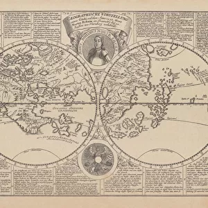
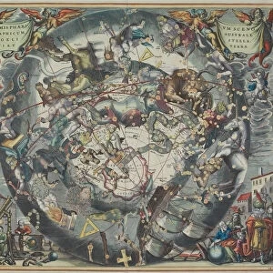
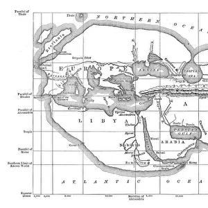
nobody, antique, vintage, archival, cartography, geography, map, history, historical, north pole, south pole, continents, world, earth, north america, south america, europe, africa, asia, australia, northern, southern, hemisphere, latitude, longitude, chart, 18th century, circles, intersecting, words, text, numbers, labels, Antique Maps, 87644530

Hemera Technologies

Media ID 14761282

© Getty Images

18th Century Australia Chart Circles Continents Earth Geography Hemisphere Labels Latitude Longitude North America North Pole Northern Numbers South America South Pole Southern Text Words World


FEATURES IN THESE COLLECTIONS

> Map > Historical Maps

> Map


MADE IN THE UK
Safe Shipping with 30 Day Money Back Guarantee

FREE PERSONALISATION*
We are proud to offer a range of customisation features including Personalised Captions, Color Filters and Picture Zoom Tools

SECURE PAYMENTS
We happily accept a wide range of payment options so you can pay for the things you need in the way that is most convenient for you

* Options may vary by product and licensing agreement. Zoomed Pictures can be adjusted in the Basket.


redeem
Beautiful Photo Prints and Gifts
image
Professionally Printed
inventory
Photo Prints are in stock
thumb_up
Professional quality finish
diamond
Made with high-grade materials
inventory_2
Carefully packed to aid safe arrival


Related Images


Map of the world, 1720
World map by Martin Behaim, 1492, wood engraving, published 1884
World map of 1869
World map of 1869
antiquity, archival, cartography, continents, geographical, geography, historic, map
abstract, ancient, antique, directions, geography, historic, map, myth, mythical
World map 1898
World map 1898
Historic Map of the Arctic, wood engraving, published in 1882
Paolo dal Pozzo Toscanelli map of earth from 15th century
Germany Vector Map
Germany Vector Map
World map according to Eratosthenes
Antique map of old world depicting voyages of Captain Cook
Map of the world
Map of the world

+

Shipping

+

Choices

+

Guaranteed