Home > History > Battles & Wars > Historcal Battle Maps and Plans
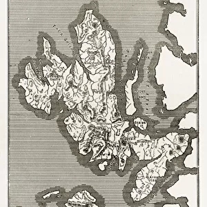
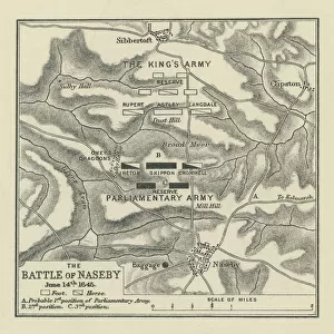
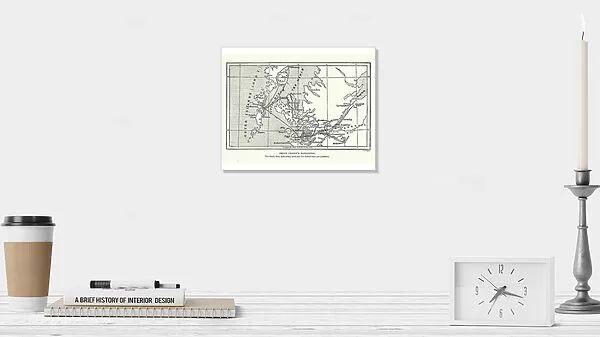
Photographic Print : Map of Bonnie Prince Charlies Wanderings

![]()
Photo Prints from Fine Art Storehouse
Map of Bonnie Prince Charlies Wanderings
Vintage caricature of Map of Bonnie Prince Charlies Wanderings after his defeat at the Battle of Culloden in 1746
duncan1890
Media ID 13667047
© duncan1890
18th Century 18th Century Style 78272 Equipment Hebrides Highland Image Created 18th Century Inner Hebrides Navigational Equipment Northern Europe Outer Hebrides Scotland Scottish Culture Scottish Highlands Styles
10"x8" (25x20cm) Photo Print
Printed on archival quality paper for unrivalled stable artwork permanence and brilliant colour reproduction with accurate colour rendition and smooth tones. Printed on professional 234gsm Fujifilm Crystal Archive DP II paper. 10x8 for landscape images, 8x10 for portrait images.
Our Photo Prints are in a large range of sizes and are printed on Archival Quality Paper for excellent colour reproduction and longevity. They are ideal for framing (our Framed Prints use these) at a reasonable cost. Alternatives include cheaper Poster Prints and higher quality Fine Art Paper, the choice of which is largely dependant on your budget.
Estimated Image Size (if not cropped) is 25.4cm x 18cm (10" x 7.1")
Estimated Product Size is 25.4cm x 20.3cm (10" x 8")
These are individually made so all sizes are approximate
Artwork printed orientated as per the preview above, with landscape (horizontal) orientation to match the source image.
FEATURES IN THESE COLLECTIONS
> History
> Battles & Wars
> Historcal Battle Maps and Plans
> Map
> Historical Maps
> Map
MADE IN THE UK
Safe Shipping with 30 Day Money Back Guarantee
FREE PERSONALISATION*
We are proud to offer a range of customisation features including Personalised Captions, Color Filters and Picture Zoom Tools
SECURE PAYMENTS
We happily accept a wide range of payment options so you can pay for the things you need in the way that is most convenient for you
* Options may vary by product and licensing agreement. Zoomed Pictures can be adjusted in the Cart.