Home > Map > USA Maps
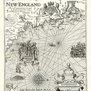
Map of New England by Explorer John Smith, Circa 1624

![]()
Wall Art and Photo Gifts from Fine Art Storehouse
Map of New England by Explorer John Smith, Circa 1624
Beautifully Illustrated Antique Engraved Victorian Illustration of Historical Map of New England from Explorer Captain John Smith, Circa 1624. Source: Original edition from my own archives. Copyright has expired on this artwork. Digitally restored
bauhaus1000
Media ID 13667109
© bauhaus1000
17th Century 17th Century Style 78271 Admiral American Culture Bay Of Water Boat Captain Chart Crossing Direction Discovery Explorer Fine Art Portrait Graph Image Created 17th Century Journey Knight Person Maine Massachusetts Navigational Equipment New England Usa Passenger Ship Period Costume Pilgrim Sailing Sailing Ship Sailor Ship The Americas Virginia Virginia Us State
FEATURES IN THESE COLLECTIONS
> Map
> Historical Maps
> Map
MADE IN THE UK
Safe Shipping with 30 Day Money Back Guarantee
FREE PERSONALISATION*
We are proud to offer a range of customisation features including Personalised Captions, Color Filters and Picture Zoom Tools
SECURE PAYMENTS
We happily accept a wide range of payment options so you can pay for the things you need in the way that is most convenient for you
* Options may vary by product and licensing agreement. Zoomed Pictures can be adjusted in the Basket.