Home > Map > Historical Maps
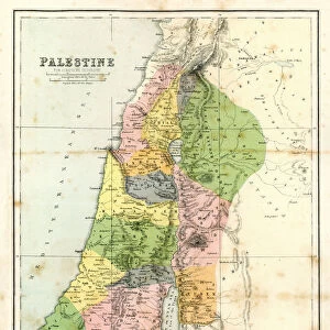
Map of Palestine, steel engraving, published in1861

![]()
Wall Art and Photo Gifts from Fine Art Storehouse
Map of Palestine, steel engraving, published in1861
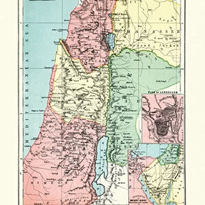
Ancient topographic map of Palestine and seperate map of Jerusalem in three eras: 1) Judges 2) Juda and Israel, 3) Maccabees to Titus (70 AD). A further separate card shows the largest expansion of the Jewish kingdom under David and Solomon (top left). Legend in Latin language. Steel engraving with hand colored borderlines, published in 1861
Media ID 13666857
© ZU_09
Antiquities Bible Canaan Valley Country And Western Music Historical Palestine Israel Israelite Jerusalem Jewish Ethnicity Judaism Judge Judge Law Land Latin Script Nation National Palestine Palestinian Past Social History State Steel Engraving Topography
FEATURES IN THESE COLLECTIONS
> Map
> Historical Maps
> Map
MADE IN THE UK
Safe Shipping with 30 Day Money Back Guarantee
FREE PERSONALISATION*
We are proud to offer a range of customisation features including Personalised Captions, Color Filters and Picture Zoom Tools
SECURE PAYMENTS
We happily accept a wide range of payment options so you can pay for the things you need in the way that is most convenient for you
* Options may vary by product and licensing agreement. Zoomed Pictures can be adjusted in the Basket.