Home > Map > Denmark Maps
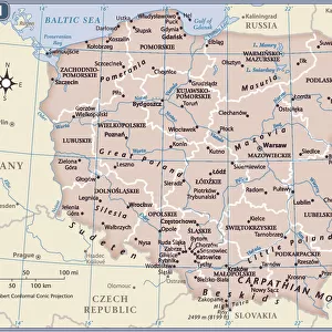
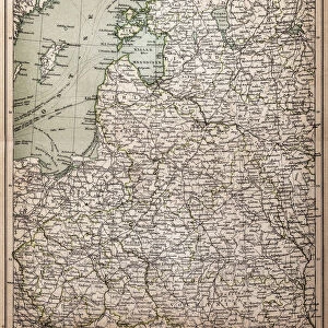
North German lowland map, 19th century view, lithograph, published 1884

![]()
Wall Art and Photo Gifts from Fine Art Storehouse
North German lowland map, 19th century view, lithograph, published 1884
Old Topographic map of the North German lowland in German language. Lithograph, published in 1884
Media ID 14756494
© This content is subject to copyright
Baltic Sea Berlin Bohemia Cologne Colorful Copenhagen Czech Republic Danzig Denmark Elbe River European Culture Gdansk German Culture Hamburg Kaliningrad Krakow Lowland North German North Sea Poland Prague Prussia Rhine Scandinavia Stuttgart Topographic Map Warsaw Wroclaw
FEATURES IN THESE COLLECTIONS
> Map
> Denmark Maps
> Map
> Historical Maps
> Map
MADE IN THE UK
Safe Shipping with 30 Day Money Back Guarantee
FREE PERSONALISATION*
We are proud to offer a range of customisation features including Personalised Captions, Color Filters and Picture Zoom Tools
SECURE PAYMENTS
We happily accept a wide range of payment options so you can pay for the things you need in the way that is most convenient for you
* Options may vary by product and licensing agreement. Zoomed Pictures can be adjusted in the Basket.