mail_outline sales@mediastorehouse.com
Northern Lights: A Dance of Colours Collection315 items
Ronny Behnert Collection85 items
Agua Volcano Collection22 items
SS United States Collection5 items
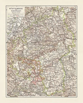
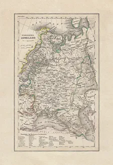
Historical map of Wurttemberg and Hohenzollern, Germany, lithograph, published 1897Historical map of Wurttemberg and the former Prussian Province of Hohenzollern (today Baden-Wurttemberg) in the German Empire. Lithograph, published in 1897
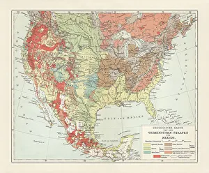
Geological map of USA and Mexico, lithograph, published in 1897Geological map of the United States of America and Mexico. Lithograph, published in 1897
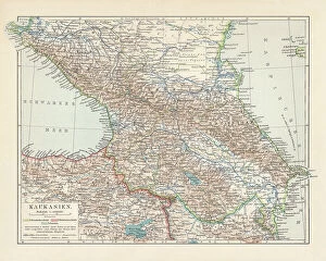
Topographic map of the Caucasus Region, lithograph, published in 1898Historical topographic map of the Caucasus Region. Lithograph, published in 1898
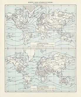
World map of the thermal extremes from 1892, lithograph, 1898World map of the thermal extremes (annual minima and annual maxima) from the year 1892. The red numbers indicate the absolute Minima (top) and Maxima (bottom). Values in degrees Celsius
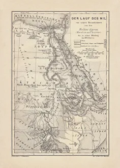
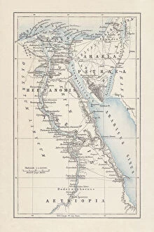
Historical map of the Nile river, wood engraving, published 1879Historical map of the course of the Nile river from the source areal to the mouth. Wood engraving, published in 1879
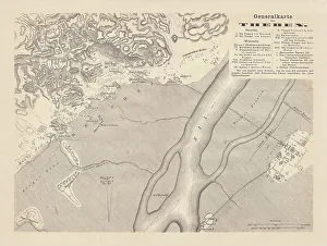
Historical map of Thebes, Egypt, wood engraving, published in 1879Historical map of Thebes, Egypt. Wood engraving, published in 1879
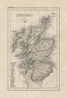
Old map of Scotland, steel engraving, published 1857Old map of Scotland. Steel engraving with hand coloured borderlines, published in 1857
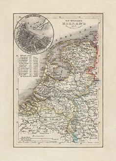
Old map of the Netherlands, steel engraving, published 1857Old map of the Netherlands and Amsterdam. Steel engraving with hand coloured borderlines, published in 1857
Old map of the European Russia, steel engraving, publishedOld map of the European Russia. Steel engraving with hand coloured borderlines, published in 1857
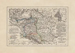
Old map of Poland, steel engraving, published in 1857Old map of the Republic and the Kingdom of Poland in 1772 with the cities of Warsaw and Vilnius. Steel engraving with hand coloured borderlines, published in 1857
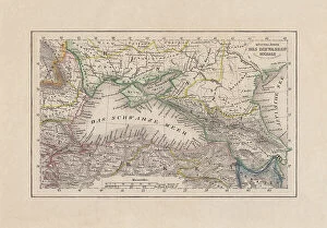
Coastal countries of the Black Sea, steel engraving, published 1857Old map of the coastal countries of the Black Sea. Steel engraving with hand coloured borderlines, published in 1857
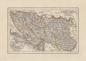
Old map of Serbia and Bosnia, steel engraving, published 1857Old map of Serbia and Bosnia. Steel engraving with hand coloured borderlines, published in 1857
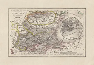
Old map of Romania and Bulgaria, steel engraving, published 1857Old map of Romania and Bulgaria. Steel engraving with hand coloured borderline, published in 1857
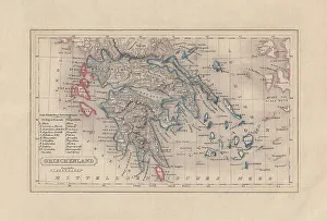
Old map of Greece, steel engraving, published 1857Old map of Greece. Steel engraving with hand coloured borderlines, published in 1857
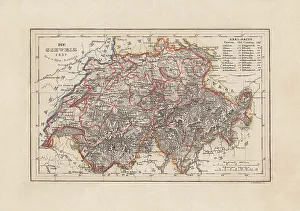
Old map of Switzerland, steel engraving, published in 1857Old map of Switzerland. Steel engraving with hand coloured borderlines, published in 1857
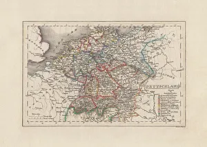
Old map of Germany, steel engraving, published in 1857Old map of Germany. Steel engraving with hand coloured borderlines, published in 1857
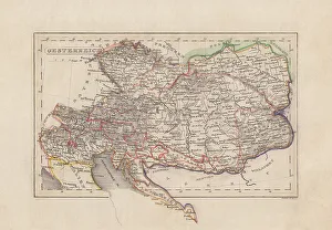
Old map of Austria (Danube monarchy), steel engraving, published 1857Old map of Austria (Danube monarchy). Steel engraving with hand coloured borderlines, published in 1857
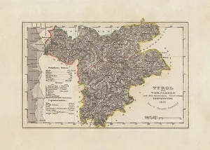
Old map of Tyrol (Austria), steel engraving, published in 1858Old map of Tyrol (Austria). Steel engraving with hand coloured borderlines, published in 1858
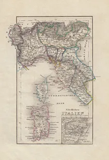
Old map of Northern Italy, steel engraving, published in 1857Old map of Northern Italy with city map of Venice. Steel engraving with hand coloured borderlines, published in 1857
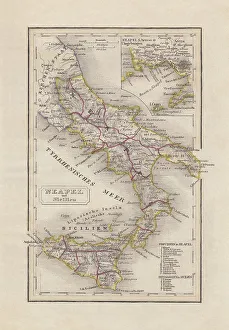
Old map of Southern Italy, steel engraving, published in 1857Old map of Southern Italy (Naples and Sicily). Steel engraving with hand coloured borderlines, published in 1857
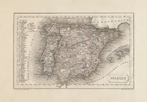
Old map of Spain and Portugal, steel engraving, published 1857Old map of Spain and Portugal. Steel engraving with hand coloured borderlines, published in 1857
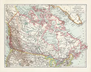
Historical map of the British North America, chromolithograph, published 1899Historical map of the British North America. It refers to the former territories of the British Empire in North America, not including the Caribbean
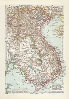
Historical map of French Indochina, chromolithograph, published in 1899Historical map of French Indochina - a grouping of French colonial territories in Southeast Asia. Chromolithograph, published in 1899
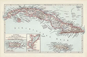
Map of Cuba, Jamaica, and Puerto Rico, chromolithograph, published 1899Historical map of the caribbean islands Cuba, Jamaica, and Puerto Rico. Chromolithograph, published in 1899
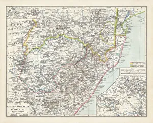
Map of South Africa during the Second Boer War, 1899-1902Topographic map of South Africa during the Second Anglo Boer War (11 October 1899 - 31 May 1902). Lithograph, published in 1900
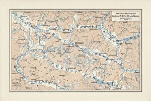
River system of Brandenburg and Saxony Anhalt, Germany, lithograph, 1900Old map of the river system of areas in Brandenburg and Saxony Anhalt, Germany. Lithograph, published in 1900
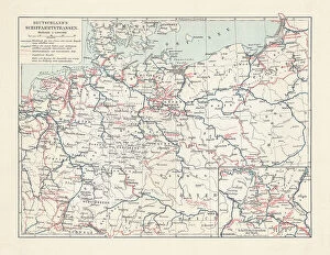
Inland waterway map of the German Empire, lithograph, published 1900Historical inland waterway map of the German Empire. Lithograph, published in 1900
Map of Egypt during the Roman Empire, lithograph, published 1893Map of ancient Egypt during the Roman Empire. Lithograph, published in 1893
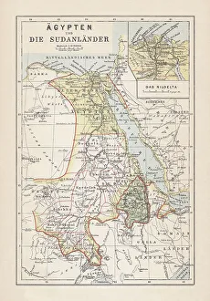
Map of Egypt, Nile Delta and Sudan, lithograph, published 1893Historical map of Egypt, Nile Delta and Sudan. Description in German. Lithograph, published in 1893
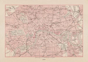
Historical city map of London, England, lithograph, published 1893Historical city map of London - capital and largest city of England and the United Kingdom. Lithograph, published in 1893
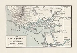
Historical map of Cameroon, lithograph, published in 1893Historical map of Cameroon during the German colonization in the late 19th century. Lithograph, published in 1893
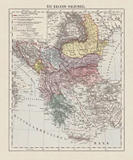
Map of the Balkan Peninsula, late 19th century, lithograph, 1893Historical map of the Balkan Peninsula, late 19th century. Explanations in German. Lithograph, published in 1893
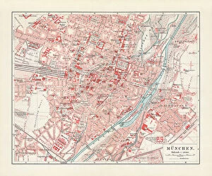
Historical city map of Munich, Bavaria, Germany, lithograph published 1897Historical city map of Munich, Bavaria, Germany. Lithograph, published in 1897
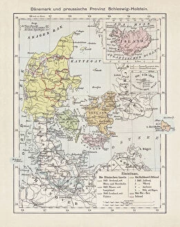
Map of Denmark, Iceland, Faroe Islands and Schleswig-Holstein. lithograph, 1893Historical map of Denmark with Iceland, the Faroe Islands and the Prussian province of Schleswig-Holstein. Lithograph, published in 1893
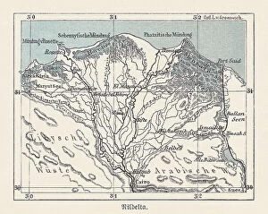
Historical map of the Nile Delta, Egypt, lithograph, published 1893Historical map of the Nile Delta in Egypt - one of the world's largest river deltas - from Alexandria in the west to Port Said in the east, it covers 240 km (150 mi) of Mediterranean coastline
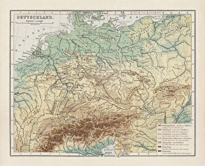
Topographic map of Germany, lithograph, published in 1893Topographic map of Germany and former territories. Lithograph, published in 1893
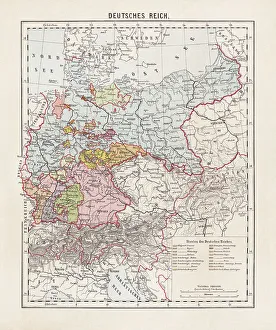
States of the German Empire, lithograph, published in 1893Map of the states of the German Empire at the end of the 19th century. Lithograph, published in 1893
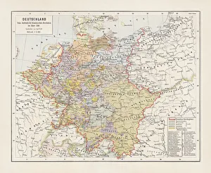
Map of Germany in 1789, lithograph, published in 1893Map of Germany with the individual states at the outbreak of the French Revolution in 1789. Lithograph, published in 1893
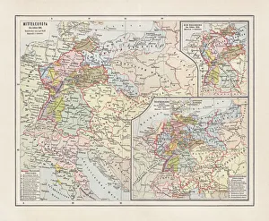
Map of Central Europe in 1811, lithograph, published in 1893Map of Central Europe in 1811. Lithograph, published in 1893
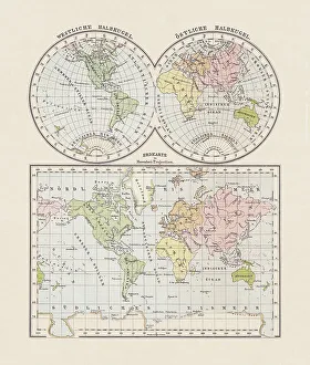
World map. Western and Eastern hemispheres, lithograph, published in 1893World map. Western and Eastern hemispheres. Descriptions in German. Lithograph, published in 1893
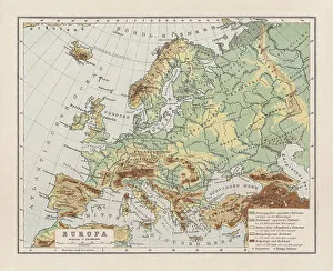
Physical map ofl Europe, lithograph, published in 1893Physical map of Europe. Descriptions in German. Lithograph, published in 1893
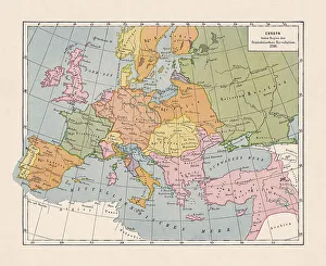
Map of Europe in 1789 (French Revolution), chromolithograph, published 1900Historical map of Europe in 1789, beginning of the French Revolution. Designations in German. Chromolithograph, published in 1900
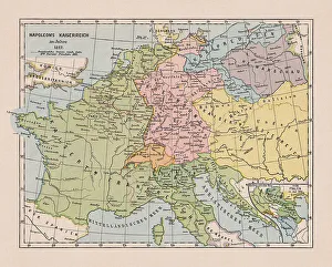
Map of the Napoleonic Empire in 1812, chromolithograph, published 1900Historical map of the Napoleonic Empire in 1812. map of the Napoleonic Empire in 1812. Chromolithograph, published in 1900
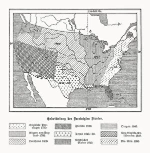
Historical development of the USA, wood engraving, published in 1899Map of the historical development of the United States of America during the 18th and 19th centuries (explanations in German). Left: English provinces 1750; Dismissed by England 1783; Louisiana 1803