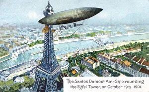
Postcard of Brazilian aviator Alberto Santos-Dumont's airship and Eiffel Tower
Alberto Santos-Dumont, 1873-1932, aviation, aviator, Brazilian, airship, dirigible, Eiffel Tower, Paris, France, October 1901, 1900s, postcards, chromolithograph, vintage, archival, midair
Aerial View, Brown, Color Image, Day, Dirt, Dirt Road, Dust, Field, Horizontal, Jeep
Aerial View, Brown, Color Image, Day, Dirt, Dirt Road, Dust, Field, Hori, Gallo Landscapes, 79436628
Govedari, Landscape, Nature, adriatic sea, aerial view, croatia, drone point of view, hdr, holiday, lifestyle, mljet, mljet national park, scenic, snorkelling, summer, swimming, tranquil scene