
Pacific Ocean Collection

Background imagePacific Ocean Collection: Halong Bay, Vietnam

Halong Bay, Vietnam
Ha Long Bay is UNESCO World Heritage Site and one of more popular travel destination in Vietnam

Background imagePacific Ocean Collection: The Scenic of Halong Bay

The Scenic of Halong Bay
Halong bay and its scenic is a UNESCO World Heritage Site, and has become a popular tourist destination located in Quang Ninh province, Vietnam

Background imagePacific Ocean Collection: Philippines map 1885

Philippines map 1885
Encyclopedia Britannica 9th Edition New York Charles Scribners and Sons 1885 Vol XVIII

Background imagePacific Ocean Collection: Costa Rica Vector Map

Costa Rica Vector Map
+++

Background imagePacific Ocean Collection: antarctica, azimuthal equal area projection, cartography, indian ocean, map, no people

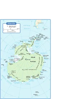
antarctica, azimuthal equal area projection, cartography, indian ocean, map, no people, pacific ocean, political map, south pole, antarctic circle, Reference Maps, 102270271

Background imagePacific Ocean Collection: Santa Monica beach, Los Angeles, California, USA

Santa Monica beach, Los Angeles, California, USA
People on the Santa Monica Beach

Background imagePacific Ocean Collection: Map of Hawaiian islands 1883

Map of Hawaiian islands 1883
Encyclopedia Britannica 9th Edition New York Samuel L. Hall 1883 Vol XI

Background imagePacific Ocean Collection: Chief Kiawanda Rock at Pacific City during Sunset

Chief Kiawanda Rock at Pacific City during Sunset
Low Tide at Cape Kiwanda with Chief Kiawanda Rock in Pacific City in Oregon Coast

Background imagePacific Ocean Collection: Panama Canal Project, lithograph, published in 1880

Panama Canal Project, lithograph, published in 1880
Ancient map of the Panama Canal Project. Lithograph, published in 1880

Background imagePacific Ocean Collection: Map of Australia 1883

Map of Australia 1883
Map of Australia

Background imagePacific Ocean Collection: Waianapanapa Sunrise

Waianapanapa Sunrise
The Road to Hana is an amazing and probably Mauis most popular drive. One of the must stops on the way is the black sand beach. The water is cold, treacherous and shark infested

Background imagePacific Ocean Collection: South America 1852 Map

South America 1852 Map

Background imagePacific Ocean Collection: Vintage Map of the World

Vintage Map of the World
Vintage map of the world from 1837

Background imagePacific Ocean Collection: Blue-ringed Octopus (Hapalochlaena sp. )

Blue-ringed Octopus (Hapalochlaena sp. )
Blue-ringed Octopus (Hapalochlaena sp.)

Background imagePacific Ocean Collection: Reflections On Chestermans Beach Of Frank Island Near Tofino

Reflections On Chestermans Beach Of Frank Island Near Tofino
British Columbia, Canada

Background imagePacific Ocean Collection: Overwater bungalows, Bora Bora, French Polynesia

Overwater bungalows, Bora Bora, French Polynesia

Background imagePacific Ocean Collection: Victoria Australia map 1885

Victoria Australia map 1885
Encyclopedia Britannica 9th Edition New York Charles Scribners and Sons 1885 Vol XXIV

Background imagePacific Ocean Collection: cartography, compass rose, indian ocean, map, melanesia, mercator projection

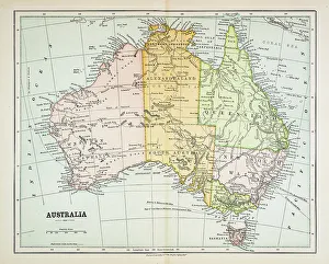
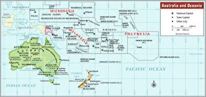
cartography, compass rose, indian ocean, map, melanesia, mercator projection, micronesia, new zealand, no people, oceania, pacific ocean, political map, polynesia, tropic of capricorn, australia

Background imagePacific Ocean Collection: Cannon Beach at Sunset

Cannon Beach at Sunset
Colorful Sunset at Cannon Beach by Haystack Rock at the Oregon Coast during Low Tide

Background imagePacific Ocean Collection: Lake Matheson with Mount Cook mirrored

Lake Matheson with Mount Cook mirrored
Matheson mirror Lake with Mount Cook at Fox Glacier. New Zealand, Westlands, South Island

Background imagePacific Ocean Collection: Holiday resort with overwater bungalows, Bora Bora, French Polynesia

Holiday resort with overwater bungalows, Bora Bora, French Polynesia

Background imagePacific Ocean Collection: Mexico map 1897

Mexico map 1897
The World-Wide Atlas of Modern Geography, Political and Physical W. & A.K. Johnston - London 1897

Background imagePacific Ocean Collection: Chart of ocean currents 1889

Chart of ocean currents 1889
Indiana Educational Series The Complete Geography - Indianapolis 1889

Background imagePacific Ocean Collection: Ocean currents map 1875

Ocean currents map 1875
The Independent Course Comprehensive Geography by James Monteith, A.S. Barnes & Co, New York & Chicago 1875

Background imagePacific Ocean Collection: View of Ha Long Bay, Quang Ninh Province, Vietnam

View of Ha Long Bay, Quang Ninh Province, Vietnam
Ha Long Bay is a UNESCO World Heritage Site and popular travel destination in Quang Ninh Province, Vietnam. Administratively, the bay belongs to H Long City, Cam Pha town

Background imagePacific Ocean Collection: Iconic view on Ha Long Bay from Hang Sung Sot (

Iconic view on Ha Long Bay from Hang Sung Sot (
Ha Long Bay has an area of around 1, 553 km2, including 1, 960 - 2, 000 islets, most of which are limestone. The core of the bay has an area of 334 km2 with a high density of 775 islets

Background imagePacific Ocean Collection: Halong Bay, Vietnam

Halong Bay, Vietnam
Morning in Ha Long Bay, UNESCO World Heritage Site

Background imagePacific Ocean Collection: Beach at sunset, The Coral Coast, Viti Levu Island, Fiji

Beach at sunset, The Coral Coast, Viti Levu Island, Fiji

Background imagePacific Ocean Collection: Karst topography of Halong Bay

Karst topography of Halong Bay
Tall isolated high limestone karst tower in UNESCO World Heritage Site Halong Bay, Vietnam

Background imagePacific Ocean Collection: Palau rock islands and tropical water from above

Palau rock islands and tropical water from above
Aerial view of lush green rock islands and clear blue tropical water of a coral reef lagoon

Background imagePacific Ocean Collection: Oakland California US City Street Map

Oakland California US City Street Map
Vector Illustration of a City Street Map of Oakland, California, USA. Scale 1:60, 000. All source data is in the public domain. U.S

Background imagePacific Ocean Collection: Engraving of Van Noort Landing in Manila Bay, Philippines, 1600

Engraving of Van Noort Landing in Manila Bay, Philippines, 1600
Very Rare, Beautifully Illustrated Antique Engraved Victorian Illustration of Historical Engraving of Van Noort Landing in Manila Bay, Philippines, 1600. Copyright has expired on this artwork

Background imagePacific Ocean Collection: Historical Map of Dutch Navigators Island of Bali Illustration

Historical Map of Dutch Navigators Island of Bali Illustration
Very Rare, Beautifully Illustrated Antique Engraved Victorian Illustration of Historical Map of Dutch Navigators on the Island of Bali. Copyright has expired on this artwork. Digitally restored

Background imagePacific Ocean Collection: Western Hemisphere map 1856

Western Hemisphere map 1856
Colton and Fitchs Modern School Geography by George W. Fitch - New York 1856

Background imagePacific Ocean Collection: American ethnographic map

American ethnographic map
Illutration of American ethnographic map

Background imagePacific Ocean Collection: Sunset at Ha Long Bay, Quang Ninh Province, Vietnam

Sunset at Ha Long Bay, Quang Ninh Province, Vietnam
Ha Long Bay is a UNESCO World Heritage Site and popular travel destination in Quang Ninh Province, Vietnam. Administratively, the bay belongs to Ha Long City, Cam Pha town

Background imagePacific Ocean Collection: Young Galapagos Sea Lions (Zalophus californianus wollebaeki)

Young Galapagos Sea Lions (Zalophus californianus wollebaeki)

Background imagePacific Ocean Collection: Halong Bay scenery

Halong Bay scenery
Large karst peaks rising high from the sea provide the striking scenery ofHalong Bay

Background imagePacific Ocean Collection: Colourful sunset behind Kicker Rock, Galapagos

Colourful sunset behind Kicker Rock, Galapagos
Kicker Rock at sunset with bird in the sky, Galapagos, Ecuador

Background imagePacific Ocean Collection: Ripples Form In The Sand At Chestermans Beach And Frank Island Near Tofino; British Columbia Canada

Ripples Form In The Sand At Chestermans Beach And Frank Island Near Tofino; British Columbia Canada

Background imagePacific Ocean Collection: Fishermans Wharf

Fishermans Wharf
Tofino, British Columbia, Canada

Background imagePacific Ocean Collection: Boats in Ha Long Bay, Quang Ninh, Vietnam

Boats in Ha Long Bay, Quang Ninh, Vietnam
A group of 4 small boats in the Halong Bay, setting not far from the limestone islands. Halong Bay is one of the most popular travel destinations in Vietnam

Background imagePacific Ocean Collection: Ha Long Bay scenery

Ha Long Bay scenery
Impressive karst rock and island formations of Ha Long Bay, Vietnam

Background imagePacific Ocean Collection: Cliffs near Vung Vieng floating fishing village, Ha Long Bay

Cliffs near Vung Vieng floating fishing village, Ha Long Bay
Karst formation cliffs tower over the calm waters of Halong Bay, Vietnam

Background imagePacific Ocean Collection: Page from the Illustrated London News with map

Page from the Illustrated London News with map

Background imagePacific Ocean Collection: Overwater bungalows, Moorea, French Polynesia

Overwater bungalows, Moorea, French Polynesia

Background imagePacific Ocean Collection: Map of Australia 1874

Map of Australia 1874
Map of Australia

Background imagePacific Ocean Collection: Inflated guineafowl puffer (Arothron meleagris)

Inflated guineafowl puffer (Arothron meleagris)
Cocos Island, Costa Rica, Pacific Ocean, Jeff Rotman Underwater Photography, 10195798


All Professionally Made to Order for Quick Shipping