Photographic Print > Map > Historical Maps
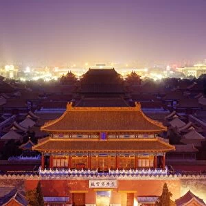
Photographic Print : Map of the world, 1720

![]()
Photo Prints from Fine Art Storehouse
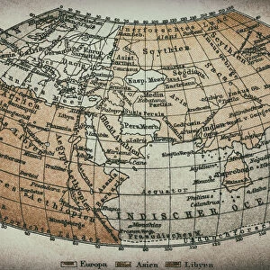
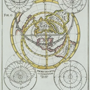
Map of the world, 1720
(Original Caption) 18th century map of the world. Published in Paris in 1720, this French map shows the known world, including the new lands that had been discovered in the preceding centuries by Europeans exploring across the Atlantic and far to the East around Africa. It divides the Earth into a western and eastern hemisphere, and uses colour to mark different areas of land. The map is by Guillaume de l Isle (1675-1726), the leading French cartographer of the eighteenth century. He was appointed Premier Geographe du Roi to King Louis XV in 1718. This edition of his world map includes the western and northern coastlines of Australia, mapped by the Dutch. Australias eastern coastline would not be mapped until 1770
Library of Congress, Geography and Map Division
Media ID 13431689
© This content is subject to copyright
18th Century 18th Century Style Americas Asian Colonialism Colony Continent Dutch Empire Eurasia Eurasian Exploration French Geographic Geographical Geography Medieval New World North America North American Old World South American Spanish The Americas World
11"x8.5" Photo Print
Photo prints are produced on Kodak professional photo paper resulting in timeless and breath-taking prints which are also ideal for framing. The colors produced are rich and vivid, with accurate blacks and pristine whites, resulting in prints that are truly timeless and magnificent. Whether you're looking to display your prints in your home, office, or gallery, our range of photographic prints are sure to impress. Dimensions refers to the size of the paper in inches.
Our Photo Prints are in a large range of sizes and are printed on Archival Quality Paper for excellent colour reproduction and longevity. They are ideal for framing (our Framed Prints use these) at a reasonable cost. Alternatives include cheaper Poster Prints and higher quality Fine Art Paper, the choice of which is largely dependant on your budget.
Estimated Image Size (if not cropped) is 27.9cm x 18.8cm (11" x 7.4")
Estimated Product Size is 27.9cm x 21.6cm (11" x 8.5")
These are individually made so all sizes are approximate
Artwork printed orientated as per the preview above, with landscape (horizontal) orientation to match the source image.
FEATURES IN THESE COLLECTIONS
> Map
> Historical Maps
> Map
MADE IN THE USA
Safe Shipping with 30 Day Money Back Guarantee
FREE PERSONALISATION*
We are proud to offer a range of customisation features including Personalised Captions, Color Filters and Picture Zoom Tools
SECURE PAYMENTS
We happily accept a wide range of payment options so you can pay for the things you need in the way that is most convenient for you
* Options may vary by product and licensing agreement. Zoomed Pictures can be adjusted in the Cart.