
East Coast Collection

Background imageEast Coast Collection: Map of Northeast United States, published in 1882

Map of Northeast United States, published in 1882
Map of the Northeast United States of America. Wood engraving, published in 1882

Background imageEast Coast Collection: The Capitol Washington

The Capitol Washington

Background imageEast Coast Collection: Zone painting, South Africa, Kafferland, East Coast of South Africa

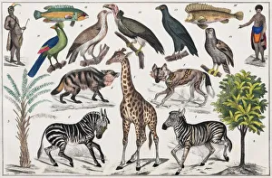
Zone painting, South Africa, Kafferland, East Coast of South Africa, from natural history and ethnology
african, coast, colorized, culture, drawing, drawn, east coast, hand-colored, historic, illustrations, natural history, ocean, regional, resident, south african, traditional, traditions

Background imageEast Coast Collection: Poolside dining

Poolside dining
UNITED STATES - CIRCA 1930s: Group of five men and women on vacation, dining poolside at hotel, Miami, Florida. (Photo by H. Armstrong Roberts/Retrofile/Getty Images)

Background imageEast Coast Collection: USA, New York, Exterior

USA, New York, Exterior
USA, New York, Adirondack Mountains, Saranac Lake, main street

Background imageEast Coast Collection: Chicago before the Great City Fire in 1871, published 1872

Chicago before the Great City Fire in 1871, published 1872
Birds eye view of Chicago before the Great City Fire in 1871. Legend: 1) West-side, 2) Union-park, 3) Gasworks, 4) Lincoln-park, 5) Washington-place, 6) Promenade, 7) North-side, 8) Waterworks

Background imageEast Coast Collection: USA, Northern States of America, map with illustrations showing distinguishing features

USA, Northern States of America, map with illustrations showing distinguishing features

Background imageEast Coast Collection: Full moon, plane wing, sunrise

Full moon, plane wing, sunrise
Full moon, blue sky, and wing of flying plane above low golden clouds at sunrise, spring, East Coast, USA

Background imageEast Coast Collection: New England 1852 Map

New England 1852 Map

Background imageEast Coast Collection: Middle States 1852 Map

Middle States 1852 Map

Background imageEast Coast Collection: United States of America, Atlantic coast, lithograph, published in 1878

United States of America, Atlantic coast, lithograph, published in 1878
United States of America, Atlantic coast. Lithograph, published in 1878

Background imageEast Coast Collection: Digital illustration of map showing 15th century European colonization of the Americas

Digital illustration of map showing 15th century European colonization of the Americas

Background imageEast Coast Collection: Moeraki Boulders, spherical rocks, East Coast, Otago, South Island, New Zealand, Oceania

Moeraki Boulders, spherical rocks, East Coast, Otago, South Island, New Zealand, Oceania


All Professionally Made to Order for Quick Shipping