mail_outline sales@mediastorehouse.com
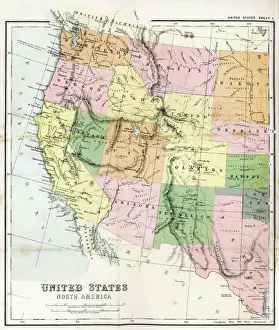
Antique Map of Western USAAntique Map from 1867 of Western United States of America
Retro Style Desert Scene with Old Gas Station and Saguaro Cactus on a sunny day
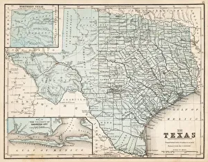
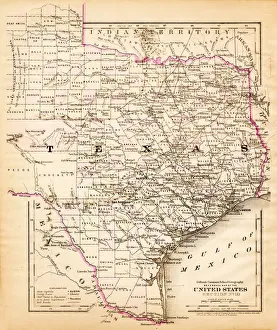
Map of Texas 1867Mitchells Modern Atlas - Published by E.H. Buttler & Co - Philadelphia 1867
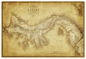
Map of Panama 1864Map of Panama - combined with 2 different texture overlays
Cape Romano sunken domessunrise over the sunken domes of Cape Romano. Once a vacation residence but two Hurricanes destroyed the island and so these abandoned buildings slowly wandered into the Gulf of Mexico
Miami Beach. Ocean Drive at nightArt Deco hotels and palm of Lummus Park in Ocean Drive, in the Art Deco district of South Beach
Public Statue of a Sailor Kissing a NursePublic Statue of a sailor kissing a nurse, Sarasota, Florida, black and white
Map of Texas 1856Colton and Fitchs Modern School Geography by George W. Fitch - New York 1856
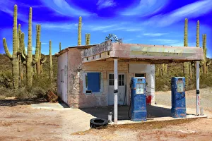
Retro Style Scene of old gas station in Arizona DesertOld gas station with prickly pear cactus in vast desert landscape
Pink lifeguard tower at South Beach, Miami, Florida, USA
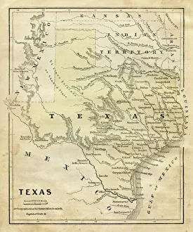
Map of Texas 1855System of Geography for the use of schools by Sidney E. Morse - Published by Harper & Brothers - New York 1855
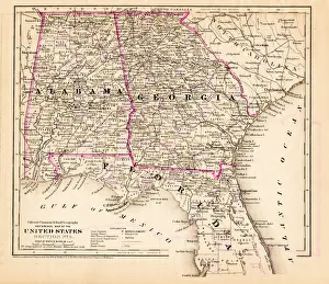
Alabama Florida Georgia map 1881Coltons Common School Geography 1881 New York Sheldon and Co
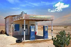
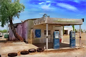
Old abandoned gas station in Arizona desertOld abandoned gas station building in Quartzsite, Arizona desert with two blue retro gas pumps. Bright sunny day. Salt Cedar tree and cactus in background
Lifeguard tower on a sunny day in South Beach, Miami, Florida, USA
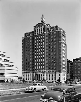
University HospitalThe University Hospital and Hillman Clinic, Birmingham, Alabama, circa 1955. (Photo by Bill Wilson Studio/Archive Photos/Getty Images)
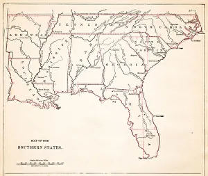
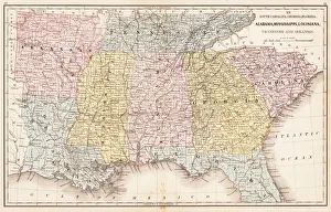
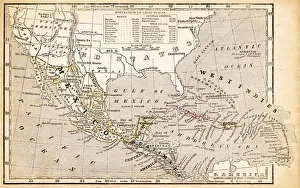
Map of Southern states USA 1883Warrens Common School Geography
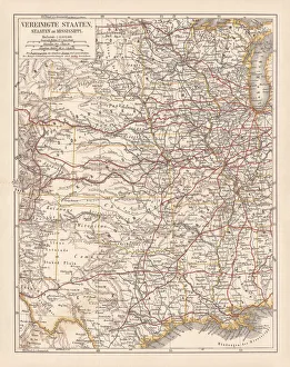
Map of USA Southern states 1869Cornells Grammars-School Geography - S.S. Cornell - New York D. Appleton and Company 1869
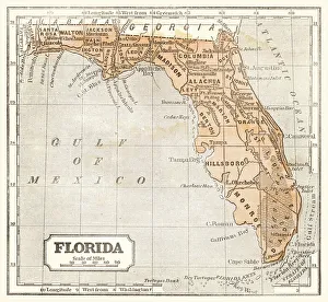
Map of Florida 1855System of Geography for the use of schools by Sidney E. Morse - Published by Harper & Brothers - New York 1855
Crested CaracaraA Crested Caracara in flight pose
Barred Owl on Perch in EvergladesAn attractive owl, with soulful brown eyes and brown-and-white-striped plumage. Originally a bird of the east, during the twentieth century it spread through the Pacific Northwest
Perched Barred OwlAn attractive owl, with soulful brown eyes and brown-and-white-striped plumage. Originally a bird of the east, during the twentieth century it spread through the Pacific Northwest
Drawing Map of Southern states USA 1883Warrens Common School Geography
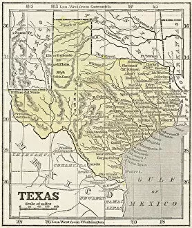
Texas map 1881Coltons Common School Geography 1881 New York Sheldon and Co
Antquie Map of the United StatesVintage map of the United States of America from 1837
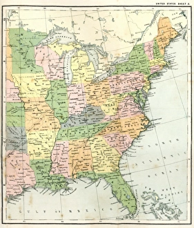
Antique Map of Eastern USAAntique Map from 1867 of Eastern United States of America
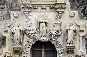
The Baroque Architecture of San Jose MissionThe facade of Mission San Jose is considered to be the best examples of Spanish Baroque in North America.This facade include Saint Joseph holding the infant Jesus, Saint Francis and Saint Dominic
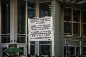
Actual entrance to the American sector in BerlinThis is the entry point to the american sector, today is a mayor tourist atraction and is on the border to the american sector of Berlin
Sunken domes of cape romanosunrise over the sunken domes of Cape Romano. Once a vacation residence but two Hurricanes destroyed the island and so these abandoned buildings slowly wandered into the Gulf of Mexico
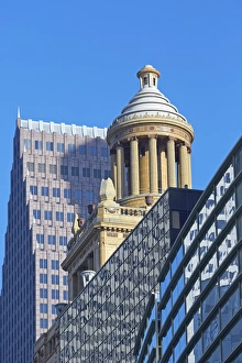
Art deco roof of the Esperson BuildingThe Art Deco roof of the Esperson Building amongst a Variety of styles of architecture in Downtown Houston. Architect Harry Stewart
Art Deco hotels on Ocean Drive at dusk
Red and white striped lifeguard hut stylized as lighthouse in South Beach, Miami, Florida, USA
Perching Barred OwlAn attractive owl, with soulful brown eyes and brown-and-white-striped plumage. Originally a bird of the east, during the twentieth century it spread through the Pacific Northwest
Souther States USA map 1881Coltons Common School Geography 1881 New York Sheldon and Co
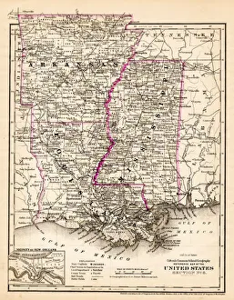
Arkansas Louisiana Pississippi map 1881Coltons Common School Geography 1881 New York Sheldon and Co
USA Southern States 1867Mitchells Modern Atlas - Published by E.H. Buttler & Co - Philadelphia 1867
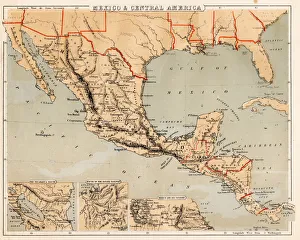
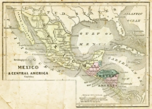
Mexico and Central America map 1869Cornells Grammars-School Geography - S.S. Cornell - New York D. Appleton and Company 1869
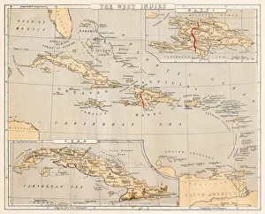
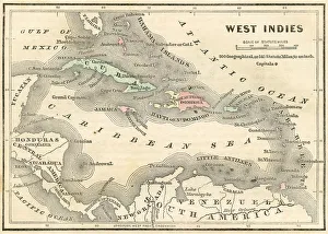
West Indies map 1869Cornells Grammars-School Geography - S.S. Cornell - New York D. Appleton and Company 1869
West Indies map 1855System of Geography for the use of schools by Sidney E. Morse - Published by Harper & Brothers - New York 1855
Mexico and Central America map 1856Colton and Fitchs Modern School Geography by George W. Fitch - New York 1856
West Indies map 1856Colton and Fitchs Modern School Geography by George W. Fitch - New York 1856
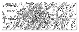
Vicinity of Chattanooga - 1886 scanned engraving
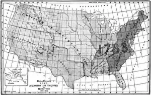
United States area: Acquisition and transfer of territory 1780 to 1870United States area: Acquisition and transfer of territory 1780 to1870
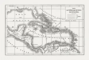
Voyages of Christopher Columbus, wood engraving, published c. 1882Map with the routes of the four voyages of Christopher Columbus in the Caribbean Sea. Wood engraving, published c. 1882
Southern States 1852 Map
United States 1852 Map
United States of America, States on Mississippi river, lithograph published 1878United States of America, States on the Mississippi river. Lithograph, published in 1878
United States of America, Atlantic coast, lithograph, published in 1878United States of America, Atlantic coast. Lithograph, published in 1878
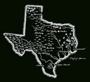
Antique Texas MapTexas Map, - Antique style. Includes mountains and water bodies. High detail - vector illustration