mail_outline sales@mediastorehouse.com
Pyramid and Great Sphinx in Giza, Egypt
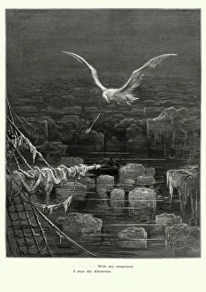
Rime of the Ancient Mariner - I shot AlbatrossVintage engraving by Gustave Dore of a scene from the Rime of the Ancient Mariner, With my crossbow I shot the Albatross. The Rime of the Ancient Mariner is the longest major poem by the English poet
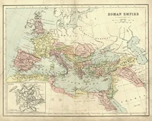
Antique map of the Roman Empire, with a detail on Rome
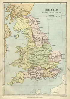
Antique map of Britain under the Anglo Saxons
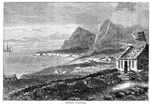
Tristan da CunhaVintage engraving from 1878 showing a view of Tristan da Cunha a remote volcanic group of islands in the south Atlantic Ocean and the main island of that group
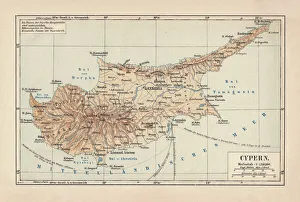
Map of Cyprus, published in 1880Ancient map of Cyprus. Lithograph, published in 1880
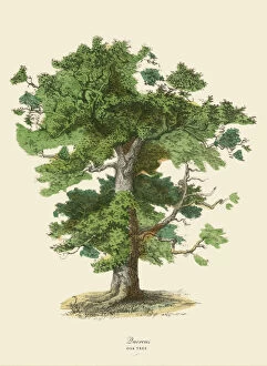
Oak Tree or Quercus, Victorian Botanical IllustrationVery Rare, Beautifully Illustrated Antique Engraved Victorian Botanical Illustration of Oak Tree or Quercus: Plate 43, from The Book of Practical Botany in Word and Image
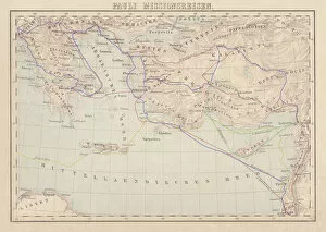
Apostle Pauls Missionary Journeys, lithograph, published in 1886Apostle Pauls Missionary Journeys: 1st (green); 2nd (red); 3rd (blue); last to Rome (yellow). Lithograph, published in 1886. Paul travelled over 10, 000 miles proclaiming the gospel of Jesus Christ
Agua Volcano and Arco de Santa Catalina (Santa Catalina Arch) in Antigua GuatemalaSanta Catalins Arch or Arco de Santa Catalina is probably the most iconic place in Antigua Guatemala, it was was built in 1693 - 1694 to allow nuns to cross the street without being seen
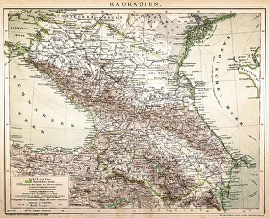
Old Caucasus mapAntique map of Caucasus
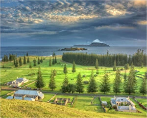
A Kingston Norfolk Island view, part of the restored British penal colony buildings and now a world heritage listed area
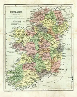
Antique map of Ireland, 1864
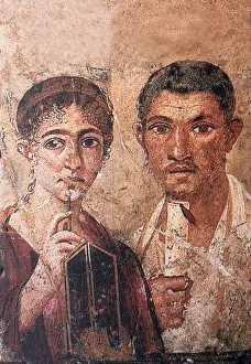
Fresco portraying Terentius Neo and his wifehistory, past, archeology, discovery, , Fresco Wall Paintings, Buena Vista Images, 170425218
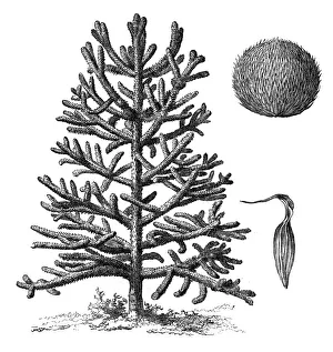
Monkey puzzle tree (araucaria imbricata)Illustration of a monkey puzzle tree (araucaria imbricata)
Bruges SunsetSunset over the central area of the historic quarter of Bruges. The belfry of Bruges and the Church of Our Lady Bruges are two prominant towers in the image
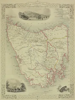
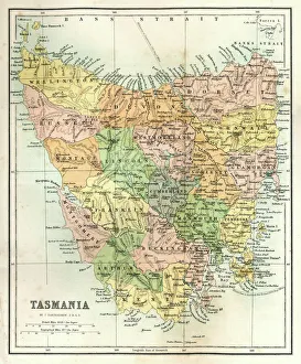
Antique map of Tasmania
Jesus Healing The SickColorized print shows Jesus as he heals a sick child held in the arms of a woman as others, in varying degrees of distress, await their turn
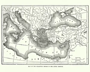
Map of the Byzantine Empire in the 9th CenturyVintage engraving of a Map of the Byzantine Empire in the 9th Century
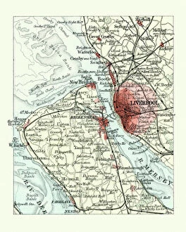
Antique map, Liverpool and Birkenhead, England, 19th CenturyVintage engraving of a Antique map, Liverpool and Birkenhead, England, 19th Century
Thylacinus cynocephalus (Tasmanian Tiger, Tasmanian Wolf, Thylacine)Illustration of a Thylacinus cynocephalus (Tasmanian Tiger, Tasmanian Wolf, Thylacine)
Sunrise with Angkor Wat, Siem Reap, Cambodia
Human Anatomy - Backbone including Ribs and PelvisVintage engraving of the human Backbone including Ribs and Pelvis. 19th Century
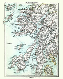
Antique map, Scotland, Jura, Mull, Argyll, Islay 19th CenturyVintage engraving of a Antique map, Scotland, Jura, Mull, Argyll, Islay 19th Century
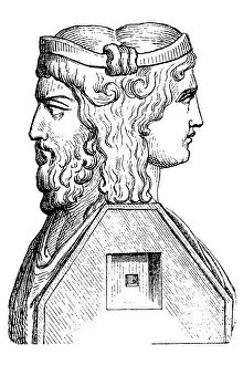
Roman God JanusIllustration of a Roman God Janus
Salisbury cathedral, Wiltshire, EnglandSalisbury cathedral in Salisbury, Wiltshire. The cathedral is one of the best examples of Early English architecture. Due to the short period of time that it was in
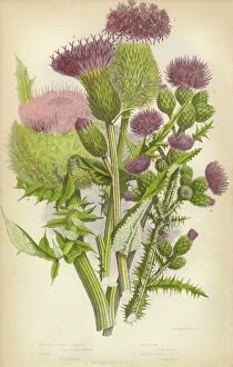
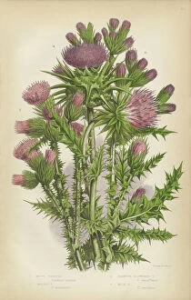
Thistle, Milk Thistle, Musk Thistle, Scotland, Victorian Botanical IllustrationVery Rare, Beautifully Illustrated Antique Engraved Thistle, Milk Thistle, Musk Thistle, Victorian Botanical Illustration Victorian Botanical Illustration
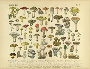
Poisonous Mushrooms, Victorian Botanical IllustrationVery Rare, Beautifully Illustrated Antique Engraved Victorian Botanical Illustration of Poisonous Mushrooms: Plate 9, from The Book of Practical Botany in Word and Image
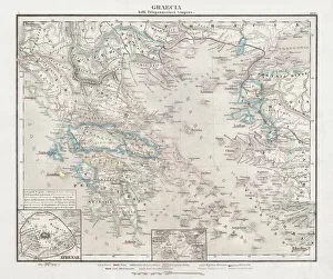
Greece at the beginning of the Peloponnesian War (431-404 BC)Antique Map of Greece at the beginning of the Peloponnesian War (431 - 404 BC) with the different tribal groups. Steel engraving with hand colored borderlines, published in 1861
Antique Map of TasmaniaAntique map of Tasmania from 1867
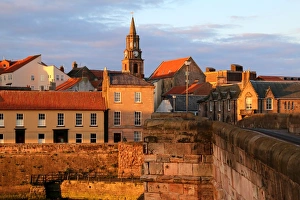
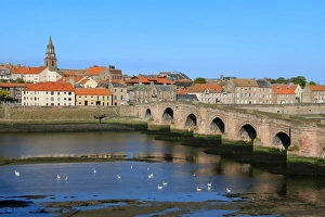
Berwick-upon-Tweed (England) in the evening sunBerwick-upon-Tweed is a town in the county of Northumberland. It is the northernmost town in England. It is located 2 1aua2 miles (4 km) south of the Scottish border
View of Berwick-upon-Tweed, EnglandBerwick-upon-Tweed is a town in the county of Northumberland. It is the northernmost town in England. It is located 2 1aua2 miles (4 km) south of the Scottish border
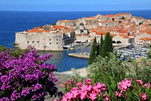
View of Old Town City of DubrovnikDubrovnik is one of the most prominent tourist destinations in the Mediterranean Sea, a seaport on the Dalmation coast. In 1979, the city of Dubrovnik joined the UNESCO list of World Heritage Sites
Viking ship, sunset, silhouette, 3D graphics
Angkor Wat Sunrise CambodiaMonumental Angkor Wat Temple in early morning light after sunrise under beautiful cloudy sky. Angkor Wat, Siem Reap, Cambodia, Asia
Cigar-Smoking ChildThree year-old Robert Quigley smoking a cigar, Washington DC, 30th August 1928. Quigley apparently started smoking when, as a one year-old on his fathers knee
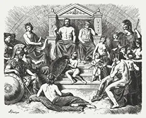
Greek gods in the Olymp, Greek mythology, published in 1880The Greek gods in the Olymp. Greek mythology. Wood engraving, published in 1880
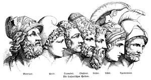
Heroes Of The Trojan WarIllustration of a Heroes Of The Trojan War
Cardiff City HallExterior image of the Cardiff City Hall lit up against a twilight sky. The city hall is an important early example of the Edwardian Baroque style
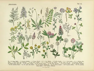
Herbs anb Spice, Victorian Botanical IllustrationVery Rare, Beautifully Illustrated Antique Engraved Victorian Botanical Illustration of Forage Herbs anb Spice: Plate 11, from The Book of Practical Botany in Word and Image
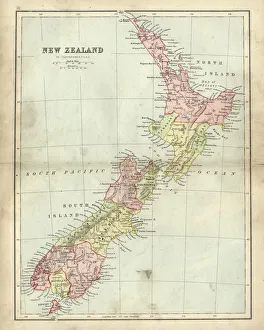
Antique map of New Zealand in the 19th Century, 1873Vintage engraving of a Antique map of New Zealand in the 19th Century, 1873
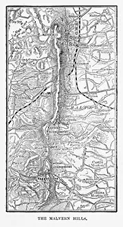
Map of Malvern Hills in Worcestershire, England Victorian Engraving, 1840Very Rare, Beautifully Illustrated Antique Engraving of Map of Malvern Hills in Worcestershire, England Victorian Engraving, 1840. Source: Original edition from my own archives
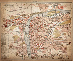
PragueAntique map of Prague from 1898
Vegetables, Fruit and Berries of the Garden, Victorian Botanical IllustrationVery Rare, Beautifully Illustrated Antique Engraved Victorian Botanical Illustration of Vegetables, Fruit and Berries of the Garden: Plate 50
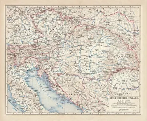
Austro-Hungarian Empire, Habsburg Monarchy, lithograph, published in 1877Ancient map of Austro-Hungarian Empire. Habsburg Monarchy. Lithograph, published in 1877
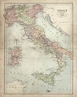
Antique Damaged Map of Italy 19th CenturyAntique damaged map of Italy 19th Century
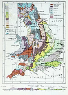
Antique colored illustrations: Geological map of England and Wales
Statue of Giordano Bruno, Campo de Fiori, at night, Rome, Lazio, Italy