
Oceania Collection

Background imageOceania Collection: Landscape: Moeraki boulders at sunset, Otago peninsula, New Zealand

Landscape: Moeraki boulders at sunset, Otago peninsula, New Zealand
Moeraki boulders at sunset, Otago peninsula, New Zealand

Background imageOceania Collection: Antique Map of Tasmania

Antique Map of Tasmania
Antique map of Tasmania from 1867

Background imageOceania Collection: Antique map of New Zealand in the 19th Century, 1873

Antique map of New Zealand in the 19th Century, 1873
Vintage engraving of a Antique map of New Zealand in the 19th Century, 1873

Background imageOceania Collection: Antique Map of New Zealand

Antique Map of New Zealand
Vintage map of New Zealand, from 1894

Background imageOceania Collection: Map of the world 1800

Map of the world 1800

Background imageOceania Collection: Milford Sound, Fiordland National Park

Milford Sound, Fiordland National Park
Milford Sound, South Island, New Zealand. Milford Sound is a fjord in the south west of New Zealands South Island, within Fiordland National Park

Background imageOceania Collection: Mt Cook at sunset reflected in lake, New Zealand

Mt Cook at sunset reflected in lake, New Zealand
Snowcapped peak of mount Cook reflecting in still lake with iceberg at sunset, Aoraki mount Cook National park, Canterbury region, South Island, New Zealand

Background imageOceania Collection: Map of the world 1869

Map of the world 1869
Cornells Grammars-School Geography - S.S. Cornell - New York D. Appleton and Company 1869

Background imageOceania Collection: Panoramic elevated view of Queenstown at dusk, New Zealand

Panoramic elevated view of Queenstown at dusk, New Zealand
Queenstown, Otago, New Zealand

Background imageOceania Collection: Antique Map of Australia

Antique Map of Australia
Vintage map of Australia, from 1894

Background imageOceania Collection: Map of Australia 1883

Map of Australia 1883
Map of Australia

Background imageOceania Collection: Vintage Map of the World

Vintage Map of the World
Vintage map of the world from 1837

Background imageOceania Collection: cartography, compass rose, indian ocean, map, melanesia, mercator projection

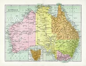
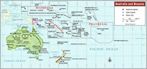
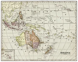
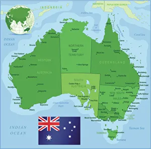
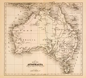
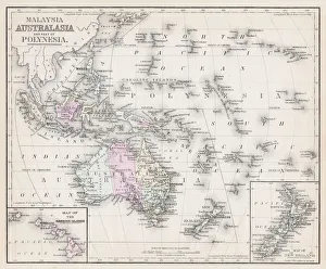
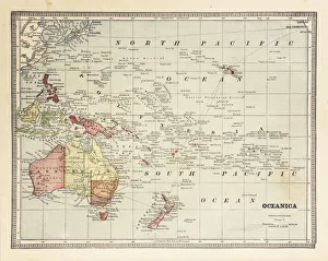
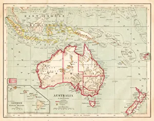
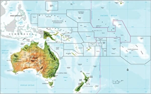
cartography, compass rose, indian ocean, map, melanesia, mercator projection, micronesia, new zealand, no people, oceania, pacific ocean, political map, polynesia, tropic of capricorn, australia

Background imageOceania Collection: World map by Mathieu Albert Lotter, Augsburg, 1778

World map by Mathieu Albert Lotter, Augsburg, 1778
World map from 1778. Original hand-colored copper engraving by Matthieu Albert Lotter (1741 - 1810, Augsburg) with route of James Cooks First Circumnavigation (1770), through Tahiti

Background imageOceania Collection: Lake Matheson with Mount Cook mirrored

Lake Matheson with Mount Cook mirrored
Matheson mirror Lake with Mount Cook at Fox Glacier. New Zealand, Westlands, South Island

Background imageOceania Collection: Map of Oceania 1877

Map of Oceania 1877
Warrens Common School Geography 1877

Background imageOceania Collection: Oceania map 1889

Oceania map 1889
Indiana Educational Series The Complete Geography - Indianapolis 1889

Background imageOceania Collection: Map of Fiji Sumatra Borneo 1897

Map of Fiji Sumatra Borneo 1897
Map of Fiji, Borneo, Sumatra, java

Background imageOceania Collection: Western Hemisphere map 1856

Western Hemisphere map 1856
Colton and Fitchs Modern School Geography by George W. Fitch - New York 1856

Background imageOceania Collection: Famous Milford Sound in a sunny day with blue sky, New Zealand

Famous Milford Sound in a sunny day with blue sky, New Zealand
Milford Sound, Fiordland National Park, New Zealand

Background imageOceania Collection: Franz Josef Glacier - Panorama View at Sunset

Franz Josef Glacier - Panorama View at Sunset

Background imageOceania Collection: Map of Australia with states, cities and flag

Map of Australia with states, cities and flag
Highly detailed vector map of Australia with states, capitals and big cities

Background imageOceania Collection: Map of Australia 1874

Map of Australia 1874
Map of Australia

Background imageOceania Collection: Map of Australia 1895

Map of Australia 1895
The Rand-McNally Grammar School Geography 1895 - Chicago & New York

Background imageOceania Collection: Antique Map of Oceania 1897

Antique Map of Oceania 1897
Antique Map of the Oceania from 1897

Background imageOceania Collection: Old map showing Rome arround 1st century BC

Old map showing Rome arround 1st century BC
Old map showing Rome circa 1st century bc Original edition from my own archives Source : Illustriertes Konversations Lexikon 1878

Background imageOceania Collection: Antique map of East Indian Archipelago

Antique map of East Indian Archipelago, including, the Phillippines, Papua New Guinea, Borneo and Java from 1891. With Detail of Batavia (Jakarta)

Background imageOceania Collection: Map of Australia and Polynesia 1877

Map of Australia and Polynesia 1877
Warrens Common School Geography 1877

Background imageOceania Collection: Australia map 1875

Australia map 1875
The Independent Course Comprehensive Geography by James Monteith, A.S. Barnes & Co, New York & Chicago 1875

Background imageOceania Collection: Winds - Map of the world 1861

Winds - Map of the world 1861
Map of the world - Winds over the globe - storms and hurricanes

Background imageOceania Collection: the world 1877

the world 1877
antique map of the world - 1877

Background imageOceania Collection: map of the world 1814

map of the world 1814
antique map showing the world with all the latest discovery of 1814

Background imageOceania Collection: Map of New Zealand 1897

Map of New Zealand 1897
Map of the city of Vienna

Background imageOceania Collection: Map of Oceania 1884

Map of Oceania 1884

Background imageOceania Collection: map of australia, malaysia and polynesia

map of australia, malaysia and polynesia
old map of australia, malaysia and polynesia - 1883

Background imageOceania Collection: map of the world 1867

map of the world 1867
meteorological map of the world 1867 - showing isothermal lines

Background imageOceania Collection: Map of the world 1861

Map of the world 1861
Map of the world - The distribution of Earthquakes and Volcanoes over the globe

Background imageOceania Collection: Animals - Map of the world 1861

Animals - Map of the world 1861
Map of the world - The distributions of animals

Background imageOceania Collection: map of the world 1873

map of the world 1873
antique map of the world - from a french atlas - 1872

Background imageOceania Collection: Climate map of the world 1861

Climate map of the world 1861
Map of the world - Climatological Chart

Background imageOceania Collection: map of the world 1855

map of the world 1855
map of the world illustrating the principal features of the land and the co-tidal lines - 1855

Background imageOceania Collection: Agricultural Map of the world 1861

Agricultural Map of the world 1861
map of the world showing the distribution of the most important Tress, Shrubs, Grains and Fruits according to zones of climate and moisture plants

Background imageOceania Collection: Oceania Australia Culture 1896

Oceania Australia Culture 1896
Oceania Australia Traditional Culture Chromolithograph

Background imageOceania Collection: Map of Australia 1877

Map of Australia 1877
The Eclectic Elementary Geography by Wilson & Hinkle / Cincinnati -New York 1881

Background imageOceania Collection: 19th Century, Aboriginal, Aborigine, Antique, Armaments, Armed, Australasia, Australasian Tribe

19th Century, Aboriginal, Aborigine, Antique, Armaments, Armed, Australasia, Australasian Tribe
Vintage engraving of a man throwing a boomerang, 19th Century

Background imageOceania Collection: North Island Of New Zealand Vector Road Map

North Island Of New Zealand Vector Road Map
Detailed vector map of North Island Of New Zealand, including main cities, roads, rivers and lakes. The colors in the.eps-file are ready for print (CMYK)

Background imageOceania Collection: compass rose, equator, indian ocean, international dateline, map, melanesia

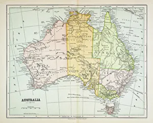
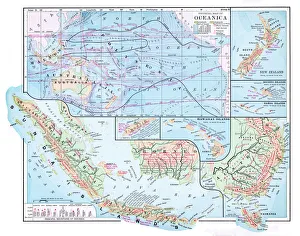
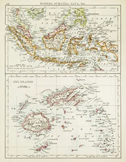
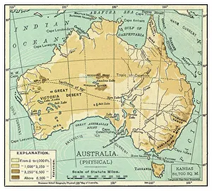
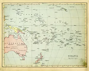
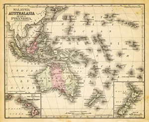
compass rose, equator, indian ocean, international dateline, map, melanesia, micronesia, new zealand, no people, oceania, pacific ocean, polynesia, relief map, topography, tropic of capricorn

Background imageOceania Collection: Oceanic People Chromolithograph 1896

Oceanic People Chromolithograph 1896
Ozeanische Volker (Oceanic People) Chromolithograph 1896


All Professionally Made to Order for Quick Shipping