mail_outline sales@mediastorehouse.com
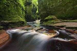
River flowing through the deep and green gorge of Finnich Glen - ScotlandRiver flowing through the deep and green gorge of Finnich Glen
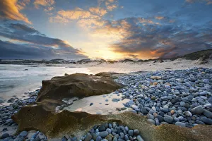
Clouds at sunset over a sand and pebble beach - Arniston South AfricaClouds at sunset over a sand and pebble beach
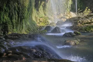
Kursunlu Waterfalls and Aksu River, Antalya, Antalya Province, Turkey
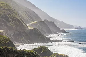
Highway 1 on California coast, Big Sur, California, USABig Sur is a lightly populated, unincorporated region on Californias Central Coast where the Santa Lucia Mountains rise abruptly from the Pacific Ocean
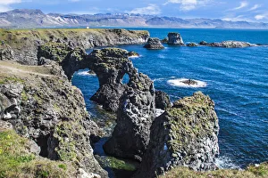
Rock formations of west coast, Arnarstapi, Snaefellsjokull, Snaefellsnes Peninsula, IcelandSnaefellsnes is a peninsula situated to the west of Borgarfjorour, in western Iceland. It has been named Iceland in Miniature, because many national sights can be found in the area
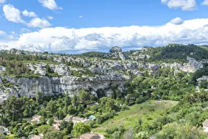
Aerial view of valley on sunny day, Les Baux de Provence, Provence, FranceLes Baux de Provence is a French commune in the Bouches-du-Rhne department of the province of Provence in the Provence-Alpes-Cote d Azur region of southern France
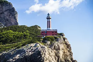
Punta Carena Lighthouse on cliff, Island of Capri, Campania, ItalyPunta Carena Lighthouse (Italian: Faro di Punta Carena) is an active lighthouse, located on the island of Capri on the head of the same name, about 3 kilometres (1.9 mi) southwest of Anacapri
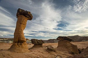
Hoodoo sandstone landscape, Grand Staircase-Escalante, Utah, USAThe Grand Staircase-Escalante National Monument (GSENM) is a United States national monument that originally designated 1, 880, 461 acres of protected land in southern Utah in 1996
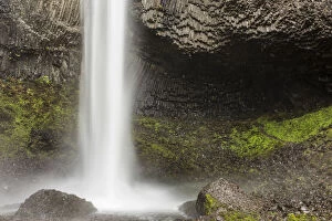
Landscape with Latourell Falls, Columbia River Gorge area, Oregon, USAA waterfall is a place where water flows over a vertical drop or a series of steep drops in the course of a stream or river
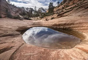
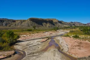
Sandstone rocks and pool, Zion National Park, Utah, USAZion National Park is a United States National Park located in southwestern Utah, near the city of Springdale. Located at the junction of the Colorado Plateau, Great Basin, and Mojave Desert regions
Saguaro (Carnegiea gigantea) in foreground of Lost Dutchman Mine State Park, Superstition Mountains, Arizona, USAThe saguaro (Carnegiea gigantea) is an arborescent (tree-like) cactus species in the monotypic genus Carnegiea, which can grow to be over 12 m tall
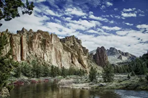
Crooked River and volcanic tuff formations, Smith Rock State Park, Oregon, USASmith Rock State Park is an American state park located in central Oregons High Desert near the communities of Redmond and Terrebonne
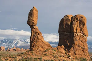
Balanced Rock in Arches National Park, with snow-covered La Sal mountains in background, Utah, USABalanced Rock is one of the most popular features of Arches National Park, situated in Grand County, Utah, United States. Balanced Rock is located next to the parks main road
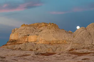
Moon and clouds at sunrise, Vermillion Cliffs, White Pocket wilderness, Arizona, USAVermilion Cliffs National Monument is located in Arizona, immediately south of the Utah state line. The Vermilion Cliffs are steep eroded escarpments consisting primarily of sandstone, siltstone
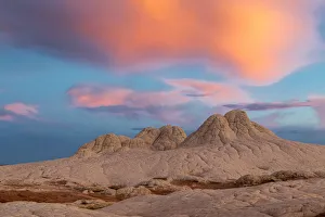
Stunning clouds at sunrise, Vermillion Cliffs, White Pocket wilderness, Arizona, USAVermilion Cliffs National Monument is located in Arizona, immediately south of the Utah state line. The Vermilion Cliffs are steep eroded escarpments consisting primarily of sandstone, siltstone
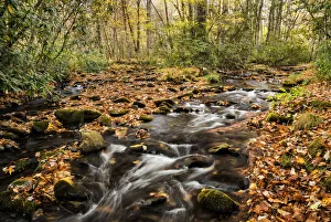
Landscape with Cataloochee Creek in Cataloochee Cove, Appalachian Mountains, Great Smoky Mountains National ParkGreat Smoky Mountains National Park is a United States National Park and UNESCO World Heritage Site that straddles the ridgeline of the Great Smoky Mountains, part of the Blue Ridge Mountains
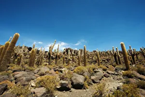
Cactus on Incahuasi island, Salar de Uyuni, BoliviaIsla Incahuasi, Inkawasi or Inka Wasi is a hilly and rocky outcrop of land and former island in Bolivia situated in the middle of Salar de Uyuni, the worlds largest salt flat, at an elevation of 3
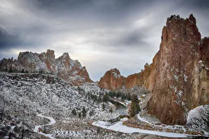
Crooked River and volcanic tuff formations in winter, Smith Rock State Park, Oregon, USASmith Rock State Park is an American state park located in central Oregons High Desert near the communities of Redmond and Terrebonne
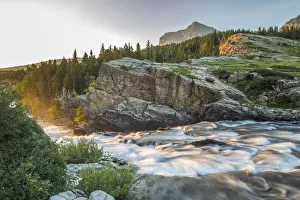
Swiftcurrent Falls stream at sunrise, Glacier National Park, Montana, USAGlacier National Park is a national park located in the U.S. state of Montana, on the Canada-United States border with the Canadian provinces of Alberta and British Columbia
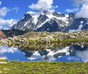
View of Mount Shuksan from Artist Point, Mount Baker Highway. Washington State, USAMount Shuksan is a glaciated massif in the North Cascades National Park. Shuksan rises in Whatcom County, Washington immediately to the east of Mount Baker
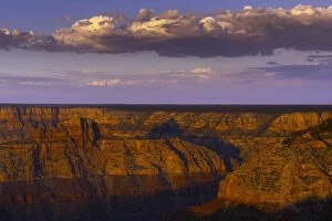
Sunrise on park formations, Grand Canyon National Park, Arizona, USAGrand Canyon National Park is the 15th site in the United States to have been named a national park. Named a UNESCO World Heritage Site in 1979, the park is located in northwestern Arizona
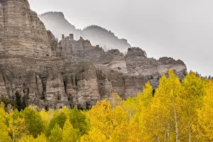
Mountain forests and formations in autumn, Gunnison National Forest, Colorado, USAThe Gunnison National Forest is a U.S. National Forest covering 6, 766.89 km2 in Mesa, Gunnison, Hinsdale and Saguache Counties in Western part of the U.S. state of Colorado
Rancheria Falls, Rancheria River, Yukon, CanadaYukon is the smallest and westernmost of Canadas three federal territories (the other two are the Northwest Territories and Nunavut)
Path leading to Professor Valley Moab, Utah, USAProfessor Valley (Highway 128) is a popular excursion out of Moab. Its also a more scenic route to Moab from Colorado if traveling on I-70
Fisher Towers, Moab, Utah, USAFisher Towers are a series of towers made of Cutler sandstone capped with Moenkopi sandstone and caked with a stucco of red mud located near Moab, Utah
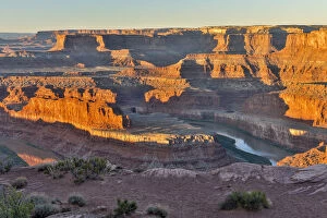
Dead Horse Point in early morning, Dead Horse State Park, Moab, Utah, USADead Horse Point State Park is a state park of Utah in the United States, featuring a dramatic overlook of the Colorado River and Canyonlands National Park
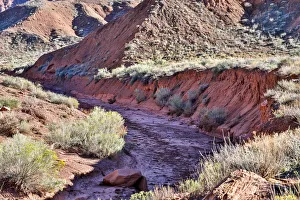
Streambed near Fisher Towers, Moab, Utah, USAA stream is a body of water with surface water flowing within the bed and banks of a channel. The stream encompasses surface and groundwater fluxes that respond to geological, geomorphological
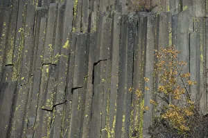
Devils Postpile National Monument, Mammoth Mountain, Mammoth Lakes, California, USADevils Postpile National Monument is a National Monument located near Mammoth Mountain in eastern California. The monument protects Devils Postpile, an unusual rock formation of columnar basalt
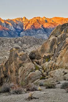
Sunrise at Eye of Alabama, Alabama Hills, Lone Pine, California, USAThe Alabama Hills are a range of hills and rock formations near the eastern slope of the Sierra Nevada in the Owens Valley, west of Lone Pine in Inyo County, California, United States
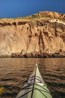
Ocean kayaking and rock formation, Isla San Jose, Baja California Sur, MexicoIsla San Jose is the second largest island in the Pearl Islands, and has an area of 44 km. At the 2000/ census, it had a population of 10
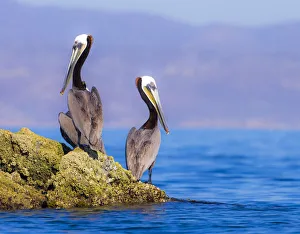
Pair of Brown Pelicans (Pelecanus occidentalis) perching on rock, Baja Peninsula, Sea of Cortez, Gulf of CaliforniaThe brown pelican (Pelecanus occidentalis) is a North American bird of the pelican family, Pelecanidae. It is one of three pelican species found in the Americas
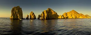
Rock formations at Sunrise, Lands End, Cabo San Lucas, Baja California, Sea of Cortez, MexicoCabo San Lucas, a resort city on the southern tip of Mexicoas Baja California peninsula, is known for its beaches, water-based activities and nightlife
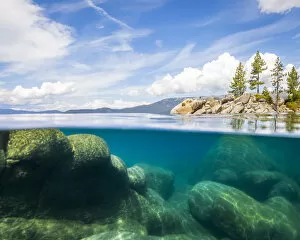
Water level view of Lake Tahoe from Sand Harbor, Nevada, USALake Tahoe is a large freshwater lake in the Sierra Nevada Mountains, straddling the border of California and Nevada. Itas known for its beaches and ski resorts
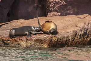
California sea lions lying on rock, Isla San Jose, Baja California Sur, MexicoThe California sea lion is a coastal eared seal native to western North America. It is one of six species of sea lion. Its natural habitat ranges from southeast Alaska to central Mexico
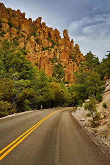
Organ Pipe Formation along highway, Chiricahua National Monument, Arizona, USAChiricahua National Monument is a unit of the National Park System located in the Chiricahua Mountains of south-eastern Arizona
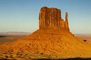
Landscape with West Mitten, Monument Valley, Arizona, USAMonument Valley, a red-sand desert region on the Arizona-Utah border, is known for the towering sandstone buttes of Monument Valley Navajo Tribal Park
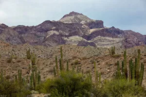
Landscape with mountain and cactus, Angel de la Guarda Island, Baja California, Sea of Cortez, MexicoIsla Angel de la Guarda, (Guardian Angel Island) also called Archangel Island, is a large island in the Gulf of California (Sea of Cortez) east of BahAia de los Angeles in north-western Mexico
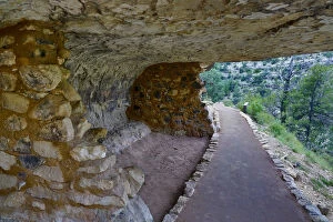
Ancient cliff dwellings, Walnut Canyon National Monument, Arizona, USAWalnut Canyon National Monument is a United States National Monument located about 10 mi (16 km) southeast of downtown Flagstaff, Arizona, near Interstate 40. The canyon rim elevation is 6, 690 ft
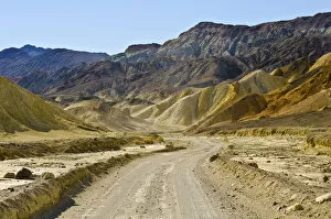
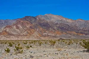
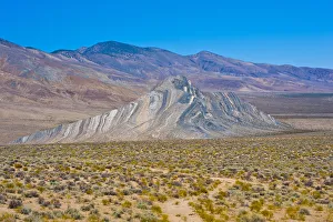
Landscape with Twenty Mule Team Canyon, Death Valley National Park, California, USADeath Valley National Park straddles eastern California and Nevada. Itas known for Titus Canyon, with a ghost town and colorful rocks, and Badwater Basinas salt flats, North Americas lowest point
Landscape with West Side Road, Death Valley National Park, California, USADeath Valley National Park straddles eastern California and Nevada. Itas known for Titus Canyon, with a ghost town and colorful rocks, and Badwater Basinas salt flats, North Americas lowest point
Landscape with Striped Butte, Butte Valley Road, Death Valley National Park, California, USADeath Valley National Park straddles eastern California and Nevada. Itas known for Titus Canyon, with a ghost town and colorful rocks, and Badwater Basinas salt flats, North Americas lowest point
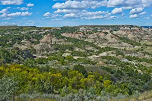
Painted Canyon Overlook, South Unit, Theodore Roosevelt National Park, Medora, North Dakota, USAPainted Canyon is a valley in Billings County, North Dakota, in the United States. It was so named on account of its colorful rocks
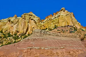
Stud Horse Point, Burr Trail Road, Boulder, Grand Staircase-Escalante National Monument, Utah, USAThe western shore of Lake Powell is bordered by sandy flats, crossed by highway US 89, but the land rises a little further west by about 600 feet to a broad mesa
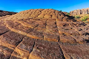
Petrified sand dunes at Snow Canyon State Park, St. George, Utah, USAThe Petrified Dunes are a series of rock formations located in Arches National Park in south-eastern Utah, United States. The dunes can be found just off of the park road between the Courthouse
View along trail to ghost town, Paria, Grand Staircase-Escalante National Monument, Utah, USAThe Grand Staircase-Escalante National Monument (GSENM) is a United States national monument that originally designated 1, 880, 461 acres of protected land in southern Utah in 1996
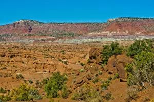
Spectacular views from Cottonwood Canyon Road, Big Water, Utah, USARoad 400 (Cottonwood Canyon Road) is a scenic 47-mile (76 km) dirt road in Kane County, Utah, United States that connects U.S. Route 89 (US-89) with South Kodachrome Road
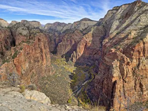
View from Angels Landing, Zion Canyon, Zion National Park, Utah, USAZion National Park is an American national park located in Southwestern Utah near the city of Springdale. A prominent feature of the 229-square-mile (590 km2) park is Zion Canyon