mail_outline sales@mediastorehouse.com
3,749 Photographic Prints
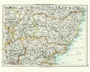
Antique map, Cambridge, Hertford, Essex, Suffolk, England 19th CenturyVintage engraving of a Antique map, Cambridge, Hertford, Essex, Suffolk, England 19th Century
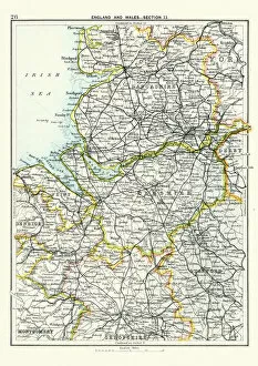
Antique map, Lancashire, Cheshire, Stafford, Liverpool, 19th CenturyVintage engraving of a Antique map, Lancashire, Cheshire, Stafford, Liverpool, Shropshire, Derby, England 19th Century
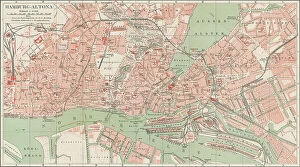
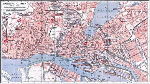
Old chromolithograph map of Altona or Hamburg-Altona, the westernmost urban borough of the German city state of HamburgAntique Illustration, Copyright has expired on this artwork. From my own archives, digitally restored
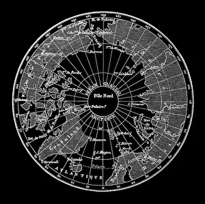
Old engraved map of North Polar RegionsAntique Illustration. Copyright has expired on this artwork. From my own archives, digitally restored
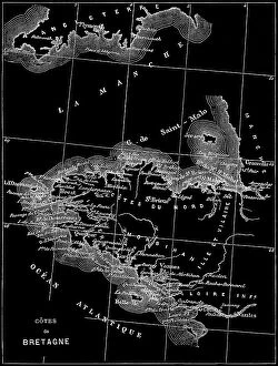
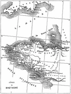
Old engraved map of Brittany, the westernmost region of Metropolitan FranceAntique Illustration, Copyright has expired on this artwork. From my own archives, digitally restored
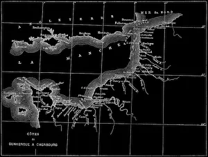
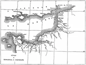
Old engraved map of the English Channel or La Manche, an arm of the Atlantic Ocean that separates Southern EnglandCopyright has expired on this artwork. From my own archives, digitally restored
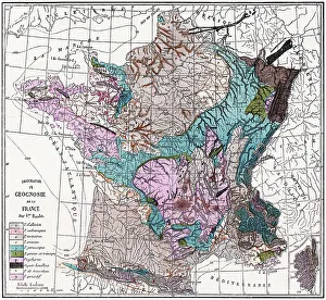
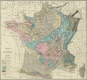
Old engraved illustration of France geological mapCopyright has expired on this artwork. From my own archives, digitally restored
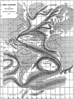
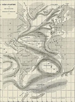
Old engraved map of Atlantic Ocean and its currentsAntique Illustration, Copyright has expired on this artwork. From my own archives, digitally restored
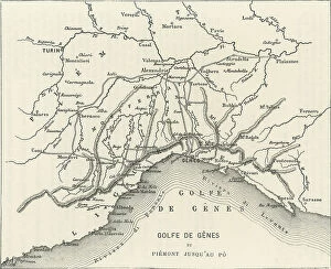
Old engraved map of the Gulf of Genoa, the northernmost part of the Ligurian Sea (largest city on its coast is Genoa)Copyright has expired on this artwork. From my own archives, digitally restored
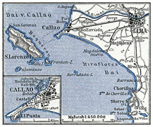
Old engraved map of Lima, the capital and largest city of Peru, located in the valleys of the ChillonCopyright has expired on this artwork. From my own archives, digitally restored
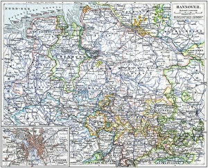
Old chromolithograph map of Hanover, capital and largest city of the German state of Lower SaxonyAntique Illustration, Copyright has expired on this artwork. From my own archives, digitally restored
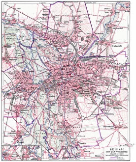
Old chromolithograph map of Leipzig (most populous city in the German state of Saxony) with its suburbsAntique Illustration, Copyright has expired on this artwork. From my own archives, digitally restored
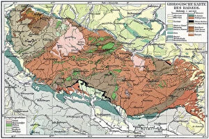
Old chromolithograph geological map of the Harz, a highland area in northern GermanyAntique Illustration, Copyright has expired on this artwork. From my own archives, digitally restored
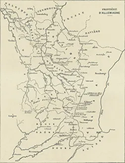
Old engraved illustration of France and Germany border mapAntique Illustration, Copyright has expired on this artwork. From my own archives, digitally restored
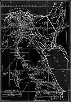
Old chromolithograph map of ancient EgyptCopyright has expired on this artwork. From my own archives, digitally restored
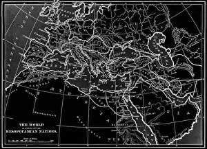
Old chromolithograph map of the World as know to the Mesopotamian NationsAntique Illustration. Copyright has expired on this artwork. From my own archives, digitally restored
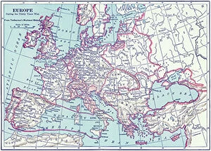
Old chromolithograph map of the Europe during the Thirty Years WarAntique Illustration. Copyright has expired on this artwork. From my own archives, digitally restored
Old chromolithograph map of the Barbarian EuropeAntique Illustration. Copyright has expired on this artwork. From my own archives, digitally restored
Old chromolithograph map of geographical knowledge at about 1800 A.DAntique Illustration. Copyright has expired on this artwork. From my own archives, digitally restored
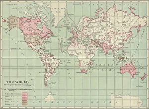
Old chromolithograph map of the World, showing the Colonial PossessionsAntique Illustration. Copyright has expired on this artwork. From my own archives, digitally restored
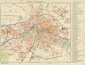
Map of Berlin and environs - The Encyclopedia Britannica -1896
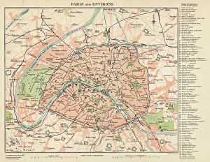
Map of Paris and environs - The Encyclopedia Britannica -1896
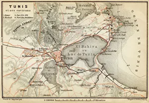
Tunisia - Lithograph Map Published 1890, Leipzig for "Italie. Manuel du Voyageur" by Karl Baedeker
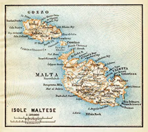
Malta island map - Lithograph Map Published 1890, Leipzig for "Italie. Manuel du Voyageur" by Karl Baedeker
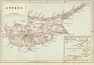
Cyprus map - Published 1884 by William Mackenzie, London for "The National Encyclopedia"
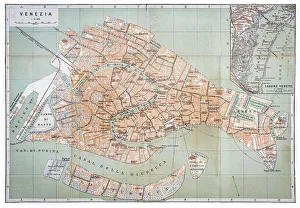
Antique map of Venice, Italy 1886
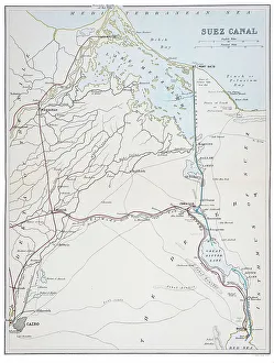
Suez Canal Map 1898Suez Canal Map 1860 - Encyclopedia Britannica 1898
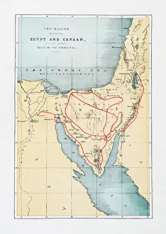
The regions between Map of Egypt and Canaan (Route of the Israelites) Holy Land Maps 1860 "The Life of our Savior Jesus Christ..." by The Rev. John Fleetwood
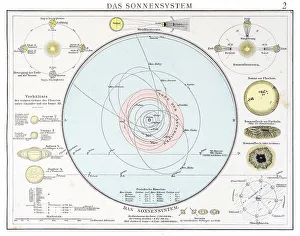
Lunar Map engraving 1896The Solar System engraving 1896
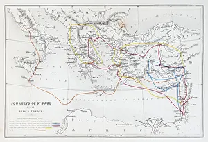
Steel Engraved Map "Journeys of St. Paul" Between Asia and Europe - Holy Land Maps 1860 "The Life of our Savior Jesus Christ..." by The Rev. John Fleetwood
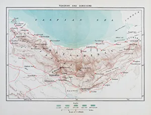
Teheran and Demavend Map 1898 - Encyclopedia Britannica 1898
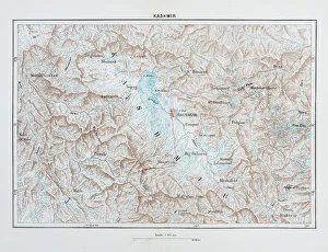
Kashmir Map 1898
Old chromolithograph map of South America continentAntique Illustration. Copyright has expired on this artwork. From my own archives, digitally restored
Old Antique map of Berlin, Germany, 19th Century, 1874
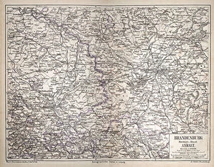
Vintage antique map of Brandenburg, Mittelmark u. Altmark, Anhalt, Germany, Berlin, Potsdam, 1870s 19th CenturyVintage antique map of Brandenburg, Mittelmark u. Altmark, Anhalt, Germany, Berlin, Ptsdam, 1870s 19th Century
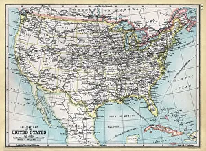
Old antique railway map of the United States of America, USA, 1890s, 19th CenturyVintage illustration Old antique railway map of the United States of America, USA, 1890s, 19th Century
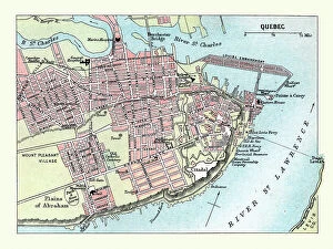
Vintage illustration Old Map of the City of Quebec, Canada, 1890s, 19th Century
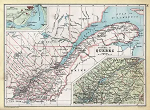
Old Map of Province of Quebec, Canada, details of Montreal area and St Lawrence river, 1890s, 19th CenturyVintage illustration Old Map of Province of Quebec, Canada, details of Montreal area and St Lawrence river, 1890s, 19th Century
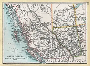
Old Map of British Columbia and part of the North West Territory, Canada, 1890s, 19th CenturyVintage illustration Old Map of British Columbia and part of the North West Territory, Canada, 1890s, 19th Century
Old Map of Manitoba and part of the North West Territory, Canada, 1890s, 19th CenturyVintage illustration Old Map of Manitoba and part of the North West Territory, Canada, 1890s, 19th Century
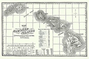
Vintage illustration Map of the Hawaiian Islands, Kauai, Oahum Molokai, Maui, Hawaii, Victorian 19th Century
Old chromolithograph map of Persian EmpireAntique Illustration, Copyright has expired on this artwork. From my own archives, digitally restored