mail_outline sales@mediastorehouse.com
799 Poster Prints
Map of USA 1898Map from the Complete Handy Atlas of the World - 1898
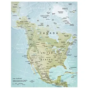
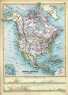
North America mapVector illustration of a detailed map of North America. Reference map was created by the US Central Intelligence Agency and is available as a public domain map at the University of Texas Libraries
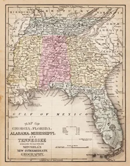
Map of USA Southern states 1881A System of Modern Geography designed for the use of schools and academies by Augustus Mitchell - Published by T. H. Butler / Philadelphia 1881
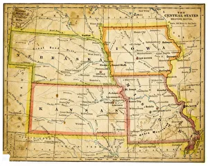
Map of USA Central states 1883The Eclectic Elementary Geography by Van Antwerp, Bragg & C0 / Cincinnati -New York 1883
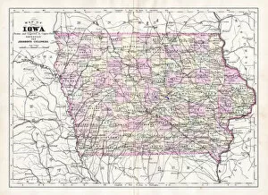
Map of Iowa USA 1894Johnsons Universal Cyclopedia - Volume IV New York - A. J. Johnson Company 1894
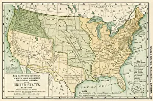
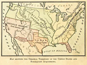
Map of the original USA territory 1881Appletons American Standard Geographies - New York 1881 - d. Appleton and Company
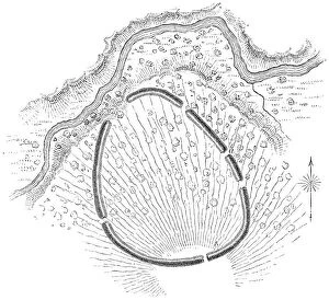
Squire Map of the Bone Fort near Oakfield in Genesee County, New York, USAThe Bone Fort near Oakfield in Genesee County, New York, United States of America. Map by Ephraim George Squier (circa mid 19th century). Vintage etching circa mid 19th century
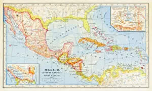
1883 Map Of Central America
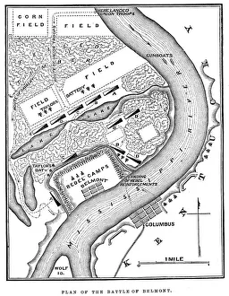
Battle of BelmontVintage engraving from 1863 of a map of the Battle of Belmont which was fought on November 7, 1861, in Mississippi County, Missouri. It was the first combat test in the American Civil War for Brig
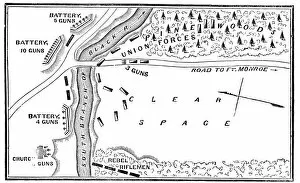
Battle of Big BethelVintage engraving from 1863 of a map of the Battle of Big Bethel also known as the Battle of Bethel Church or Great Bethel was an American Civil War battle that took place on June 10, 1861
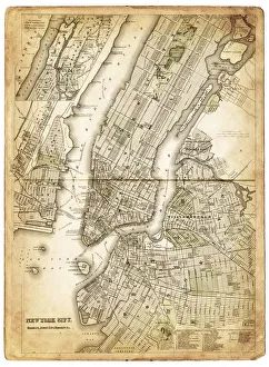
map of new york city 1874very old map showing new york city, new jersey, and hoboken) 1874 - composite with grunge sepia paper
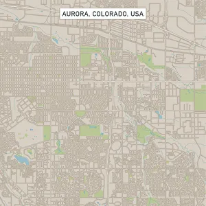
Aurora Colorado US City Street MapVector Illustration of a City Street Map of Aurora, Colorado, USA. Scale 1:60, 000. All source data is in the public domain. U.S
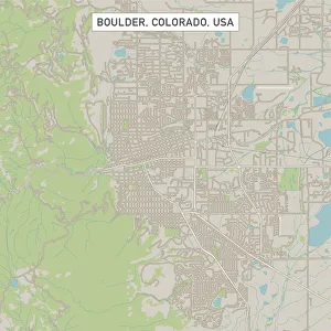
Boulder Colorado US City Street MapVector Illustration of a City Street Map of Boulder, Colorado, USA. Scale 1:60, 000. All source data is in the public domain. U.S
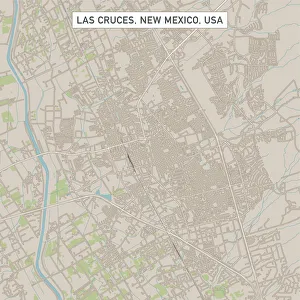
Las Cruces New Mexico US City Street MapVector Illustration of a City Street Map of Las Cruces, New Mexico, USA. Scale 1:60, 000. All source data is in the public domain. U.S
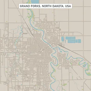
Grand Forks North Dakota US City Street MapVector Illustration of a City Street Map of Grand Forks, North Dakota, USA. Scale 1:60, 000. All source data is in the public domain. U.S
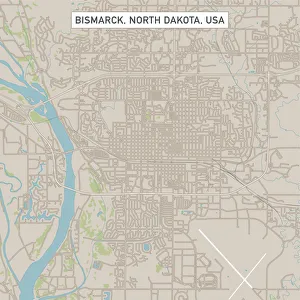
Bismarck North Dakota US City Street MapVector Illustration of a City Street Map of Bismarck, North Dakota, USA. Scale 1:60, 000. All source data is in the public domain. U.S
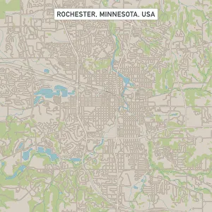
Rochester Minnesota US City Street MapVector Illustration of a City Street Map of Rochester, Minnesota, USA. Scale 1:60, 000. All source data is in the public domain. U.S
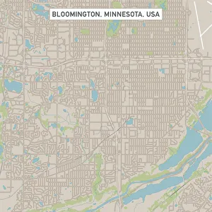
Bloomington Minnesota US City Street MapVector Illustration of a City Street Map of Bloomington, Minnesota, USA. Scale 1:60, 000. All source data is in the public domain. U.S
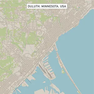
Duluth Minnesota US City Street MapVector Illustration of a City Street Map of Duluth, Minnesota, USA. Scale 1:60, 000. All source data is in the public domain. U.S
Rapid City South Dakota US City Street MapVector Illustration of a City Street Map of Rapid City, South Dakota, USA. Scale 1:60, 000. All source data is in the public domain. U.S
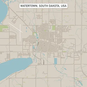
Watertown South Dakota US City Street MapVector Illustration of a City Street Map of Watertown, South Dakota, USA. Scale 1:60, 000. All source data is in the public domain. U.S
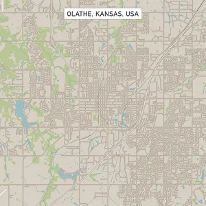
Olathe Kansas US City Street MapVector Illustration of a City Street Map of Olathe, Kansas, USA. Scale 1:60, 000. All source data is in the public domain. U.S
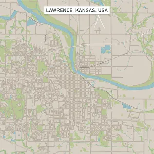
Lawrence Kansas US City Street MapVector Illustration of a City Street Map of Lawrence, Kansas, USA. Scale 1:60, 000. All source data is in the public domain. U.S
Independence Missouri US City Street MapVector Illustration of a City Street Map of Independence, Missouri, USA. Scale 1:60, 000. All source data is in the public domain. U.S
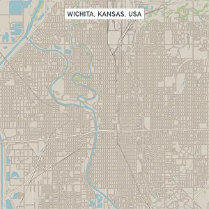
Wichita Kansas US City Street MapVector Illustration of a City Street Map of Wichita, Kansas, USA. Scale 1:60, 000. All source data is in the public domain. U.S
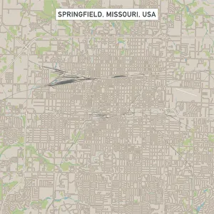
Springfield Missouri US City Street MapVector Illustration of a City Street Map of Springfield, Missouri, USA. Scale 1:60, 000. All source data is in the public domain. U.S
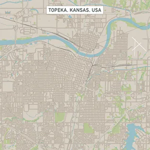
Topeka Kansas US City Street MapVector Illustration of a City Street Map of Topeka, Kansas, USA. Scale 1:60, 000. All source data is in the public domain. U.S
Broken Arrow Oklahoma US City Street MapVector Illustration of a City Street Map of Broken Arrow, Oklahoma, USA. Scale 1:60, 000. All source data is in the public domain. U.S
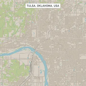
Tulsa Oklahoma US City Street MapVector Illustration of a City Street Map of Tulsa, Oklahoma, USA. Scale 1:60, 000. All source data is in the public domain. U.S
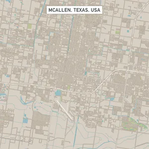
McAllen Texas US City Street MapVector Illustration of a City Street Map of McAllen, Texas, USA. Scale 1:60, 000. All source data is in the public domain. U.S
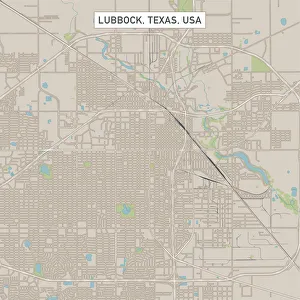
Lubbock Texas US City Street MapVector Illustration of a City Street Map of Lubbock, Texas, USA. Scale 1:60, 000. All source data is in the public domain. U.S
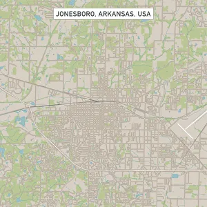
Jonesboro Arkansas US City Street MapVector Illustration of a City Street Map of Jonesboro, Arkansas, USA. Scale 1:60, 000. All source data is in the public domain. U.S
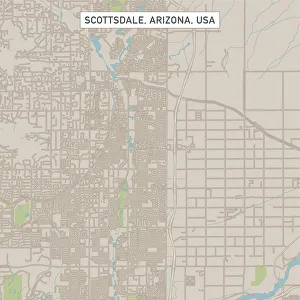
Scottsdale Arizona US City Street MapVector Illustration of a City Street Map of Scottsdale, Arizona, USA. Scale 1:60, 000. All source data is in the public domain. U.S
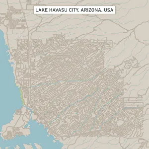
Lake Havasu City Arizona US City Street MapVector Illustration of a City Street Map of Lake Havasu City, Arizona, USA. Scale 1:60, 000. All source data is in the public domain. U.S
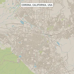
Corona California US City Street MapVector Illustration of a City Street Map of Corona, California, USA. Scale 1:60, 000. All source data is in the public domain. U.S
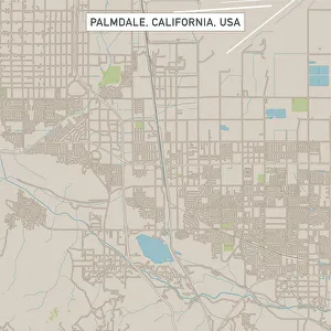
Palmdale California US City Street MapVector Illustration of a City Street Map of Palmdale, California, USA. Scale 1:60, 000. All source data is in the public domain. U.S
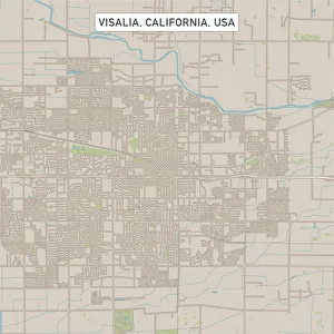
Visalia California US City Street MapVector Illustration of a City Street Map of Visalia, California, USA. Scale 1:60, 000. All source data is in the public domain. U.S
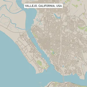
Vallejo California US City Street MapVector Illustration of a City Street Map of Vallejo, California, USA. Scale 1:60, 000. All source data is in the public domain. U.S
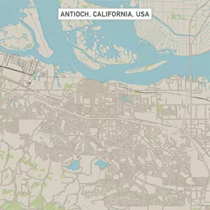
Antioch California US City Street MapVector Illustration of a City Street Map of Antioch, California, USA. Scale 1:60, 000. All source data is in the public domain. U.S
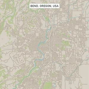
Bend Oregon US City Street MapVector Illustration of a City Street Map of Bend, Oregon, USA. Scale 1:60, 000. All source data is in the public domain. U.S
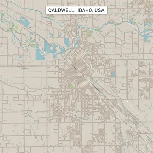
Caldwell Idaho US City Street MapVector Illustration of a City Street Map of Caldwell, Idaho, USA. Scale 1:60, 000. All source data is in the public domain. U.S
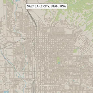
Salt Lake City Utah US City Street MapVector Illustration of a City Street Map of Salt Lake City, Utah, USA. Scale 1:60, 000. All source data is in the public domain. U.S
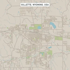
Gillette Wyoming US City Street MapVector Illustration of a City Street Map of Gillette, Wyoming, USA. Scale 1:60, 000. All source data is in the public domain. U.S
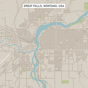
Great Falls Montana US City Street MapVector Illustration of a City Street Map of Great Falls, Montana, USA. Scale 1:60, 000. All source data is in the public domain. U.S
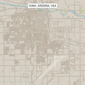
Yuma Arizona US City Street MapVector Illustration of a City Street Map of Yuma, Arizona, USA. Scale 1:60, 000. All source data is in the public domain. U.S
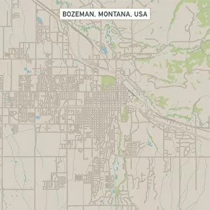
Bozeman Montana US City Street MapVector Illustration of a City Street Map of Bozeman, Montana, USA. Scale 1:60, 000. All source data is in the public domain. U.S
Old Map of North America, Cross section of Canada and USA, 1890s, 19th CenturyVintage illustration Old Map of North America, Cross section of Canada and USA, 1890s, 19th Century
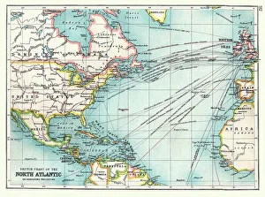
Old Sketch chart of the North Atlantic on Mercator projection, Shipping routes, Europe, North and South America, 1890sVintage illustration Old Sketch chart of the North Atlantic on Mercator projection, Shipping routes, Europe, North and South America, 1890s, 19th Century