Home > Map
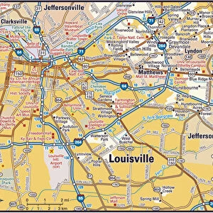
Course of the Great Storm of 1890 in the USA

![]()
Wall Art and Photo Gifts from Fine Art Storehouse
Course of the Great Storm of 1890 in the USA
A map showing the course of the Great Storm in late March 1890 in the United States of America, during which the city of Louisville, Kentucky, was partially destroyed: it was known as the Louisville Cyclone. From " Harpers Weekly - A Journal of Civilization" Volume XXXIV No. 1737 of Saturday 5th April 1890. Published by Harper & Brothers and costing 10 cents including supplement
whitemay
Media ID 19802699
© Digitally restored by Linda Steward
Climate Destruction Natu Storm Weather Wind
FEATURES IN THESE COLLECTIONS
> Map
MADE IN THE UK
Safe Shipping with 30 Day Money Back Guarantee
FREE PERSONALISATION*
We are proud to offer a range of customisation features including Personalised Captions, Color Filters and Picture Zoom Tools
SECURE PAYMENTS
We happily accept a wide range of payment options so you can pay for the things you need in the way that is most convenient for you
* Options may vary by product and licensing agreement. Zoomed Pictures can be adjusted in the Basket.