mail_outline sales@mediastorehouse.com
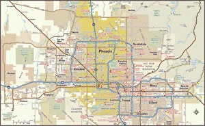
Phoenix, Arizona area map2011 edition
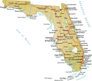
Map of FloridaVector illustratio of map of Florida with major roads, rivers and lakes
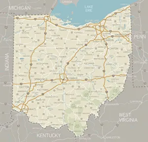
Ohio MapA detailed map of Ohio state with cities, roads, major rivers, and lakes plus National Forests. Includes neighboring states and surrounding water
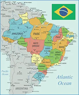
Brazil Map with Rivers and National FlagVintage Map of Brazil. Vector Illustration with Rivers and National Flag
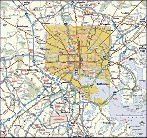
Baltimore, Maryland area2011 edition
Jesus Reaching for a Lost Sheep
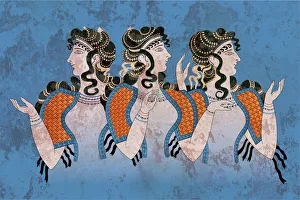
Fresco Three Minoan Women KnossosMinoan Fresco of the Ladies in Blue depicts the women in the open blouse that was typical in the later Minoan Culture. The fresco fragments were discovered during the excavation of a Minoan site in
Pink Floyds Inflatable Pig Battersea Power StationA 40-foot long inflatable pig suspended between two of the chimneys at Battersea Power Station, London, during a photoshoot for the cover of Pink Floyds album Animals, 6th November 1976
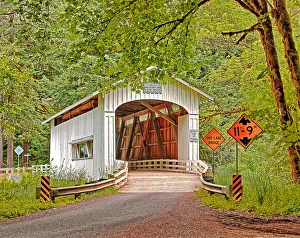
Wildcat Creek Covered BridgeA color HDR photograph of Wildcat Creek Covered Bridge in rural Lane County, Oregon. The bridge was built in 1925 to carry Austa Road over Wildcat Creek
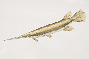
Longnose Gar (Lepisosteus osseus), long fish with a long horn like mouth and golden skin with brown blotches
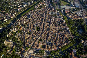
City centre, Montelimar, Rhone-Alpes, France
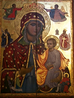
Israel, Jerusalem, Church of the Holy SepulchreJerusalem, Church of the Holy Sepulchre, Greek Golden Icon (Orthodox Church), Virgin Mary with Jesus
Taxi CabA taxi cab in the streets of New York City in the 1950 s. (Photo by Archive Photos/Getty Images)
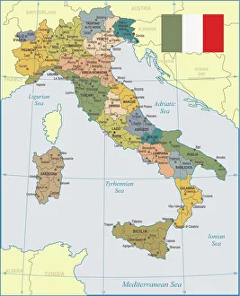
Italy Map - illustrationColored Map of Italy The urls of the reference files are (country, continent, world map and globe). http://www.lib.utexas.edu/maps/europe/italy_admin_06.jpg http
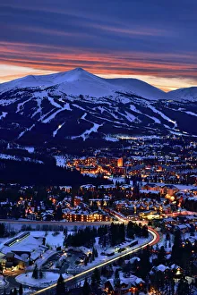
Breckenridge Ski Resort at DuskThis image was taken in Breckenridge, Colorado after sunset. The town is at the base of the Rocky Mountains Tenmile Range
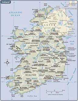
Ireland country map2011 edition
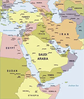
Map of Middle East - illustrationColored Map of Middle East Asia with Country Names and Capital Cities
Praying Hands by Albrecht DurerPraying hands by the German artist Albrecht Durer (1471 - 1528), circa 1500. (Photo by Hulton Archive/Getty Images) Praying hands, also known as Study of the Hands of an Apostle
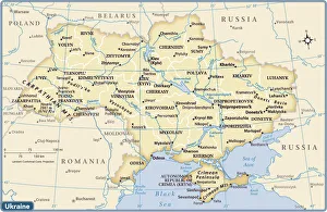
Ukraine country map2011 edition
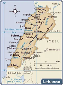
Lebanon country map2011 edition
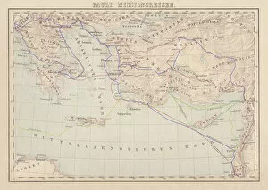
Apostle Pauls Missionary Journeys, lithograph, published in 1886Apostle Pauls Missionary Journeys: 1st (green); 2nd (red); 3rd (blue); last to Rome (yellow). Lithograph, published in 1886. Paul travelled over 10, 000 miles proclaiming the gospel of Jesus Christ
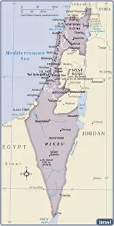
Israel Country Map 2011 EditionIsrael is a country in the Middle East, located at the eastern end of the Mediterranean Sea. It is bounded to the north by Lebanon, to the northeast by Syria, to the east and southeast by Jordan
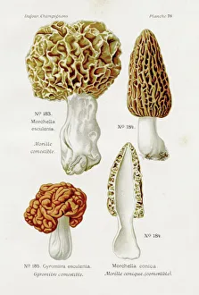
Morel mushroom 1891Atlas des Champignons, L. Dufour 1891
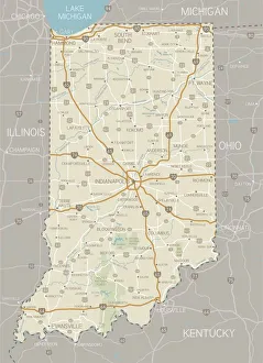
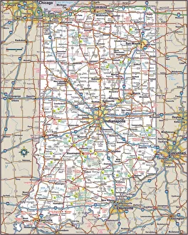
Indiana MapA detailed map of Indiana state with cities, roads, major rivers, and lakes plus National Forests. Includes neighboring states and surrounding water
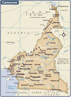
Cameroon country map2011 edition
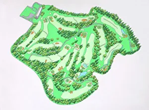
Illustrated map of Augusta National Golf Course, Augusta, Georgia, USA
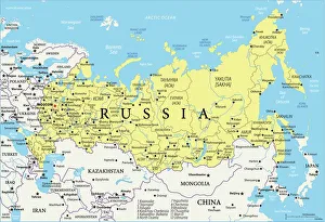
Map of RussiaReference Map of Russia
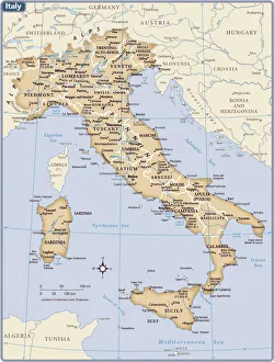
Italy country map2011 edition
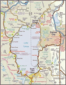
Lake Tahoe Area Map2010 edition. South Lake Tahoe and North Lake Tahoe are comprised of small cities and towns located in California and Nevada
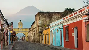
Agua Volcano and Arco de Santa Catalina (Santa Catalina Arch) in Antigua GuatemalaSanta Catalins Arch or Arco de Santa Catalina is probably the most iconic place in Antigua Guatemala, it was was built in 1693 - 1694 to allow nuns to cross the street without being seen
Woman Holding a Huge Cup of CoffeeThe photograph showcases a woman, her face radiating contentment, as she cradles an enormous cup filled to the brim with steaming hot chocolate or coffee
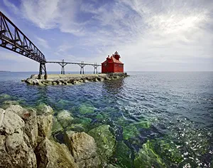
Sturgeon Bay Lighthouse Door County WisconsinUSA Wisconsin Door County Sturgeon Bay North Pierhead Ship Canal Lighthouse. Door County, Wisconsin
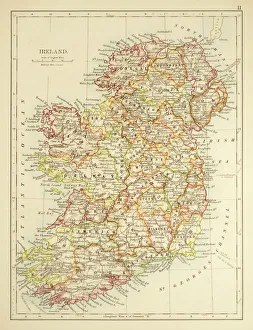
Map of Ireland 1897Map of Ireland
Search And DestroyThe second wave of combat helicopters of the 1st Air Cavalry Division fly over an RTO and his commander on an isolated landing zone during Operation Pershing
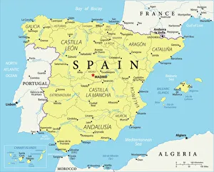
Reference Map of SpainThe Spain Map shows that Spain is situated in south-western Europe. Spain is bordered by Mediterranean Sea, Gibraltar, France, Andorra, Bay of Biscay, Atlantic Ocean and Portugal
coronavirus, 3d render
Woman Waterskiinghttp://csaimages.com/images/istockprofile/csa_vector_dsp.jpg
Arrowhead Golf Course, Autumn ViewArrowhead Golf Course, nestled in the foothills of the Rockies, Denver, CO with the towering red sandstone rock formations
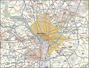
Washington, DC area map2011 edition
Indiana Highway MapReference Maps, Top Sellers Art Prints, 103312674
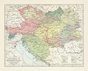
Ethnological map of the Austro-Hungarian Empire, lithograph, published in 1897Ethnological map of the Austro-Hungarian Empire. Lithograph, published in 1897
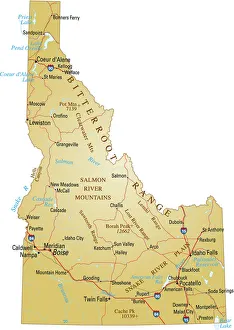
Map of IdahoVector illustration of map of Idaho with major roads, rivers and lakes
Basset Hound with Outstretched EarsThe large, floppy ears of the Basset Hound have a job to do. As a they trot across the ground, their ears help bring smells directly to their face
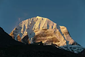
Tibetan Buddhism, snow-capped sacred Mount Kailash, or Gang Rinpoche, pilgrims trail, Kora, Ngari, Gang-Tise Mountains, Transhimalaja, Himalaja, Western Tibet, Tibet Autonomous Region
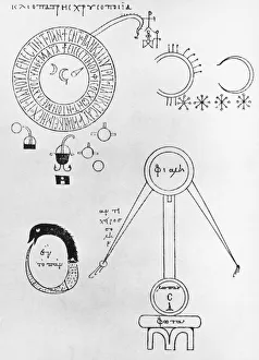
Chrysopoeia Of CleopatraAlchemical symbols from the Chrysopoeia of Cleopatra, an early Greek manuscript, circa 100 AD. On the lower left is an Ouroboros, a serpent eating its own tail
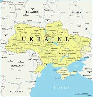
Map of UkraineReference Maps of Ukraine
Close up portrait of Blue-footed booby in the GalapagosOutdoors, Day, Bird, Standing, Photography, Side View, Looking Away, Ec, Blue footed booby (Sula nebouxii) Prints, 685037051
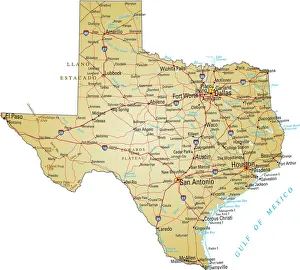
Map of TexasVector illustration of map of Texas with major roads, rivers and lakes