mail_outline sales@mediastorehouse.com
Choose a picture from our Map Illustrations Collection for your Wall Art and Photo Gifts
149 items
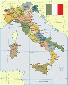
Italy Map - illustrationColored Map of Italy The urls of the reference files are (country, continent, world map and globe). - The illustration was completed January 09
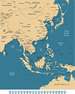
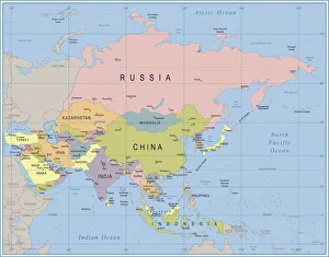
East Asia MapBeige Sea Blue Map of East Asia - illustration
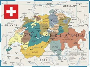
Map of Switzerland - Vector illustration
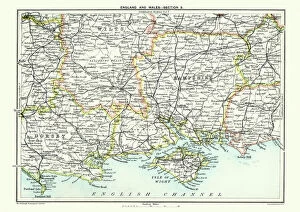
Map of South East England, Hampshire, Dorset, Wiltshire 1891Antique Map of Map of South East England, showing Hampshire, Dorset, Wiltshire, and the Isle of Wight 1891
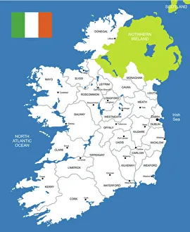
Map of IrelandDetailed map of Ireland
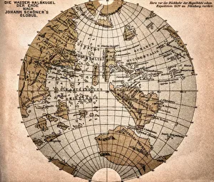
World map from 1520Western hemisphere of the Johannes SchAoner globe from 1520. expedition
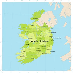
Ireland Vector MapHighly detailed vector map of the Republic of Ireland. File was created on June 24, 2011. The colors in the.eps-file are ready for print (CMYK). Included files: EPS (v8) and Hi-Res JPG
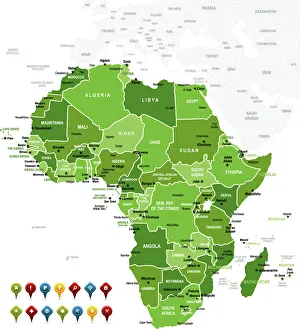
Africa MapAfrica Green High detailed map with navigation icons
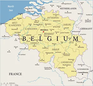
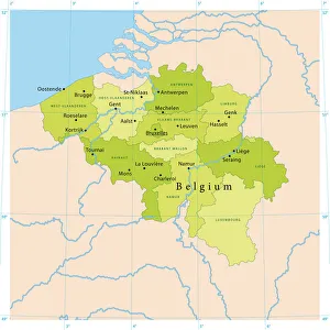
Map of Belgium - Vector illustration
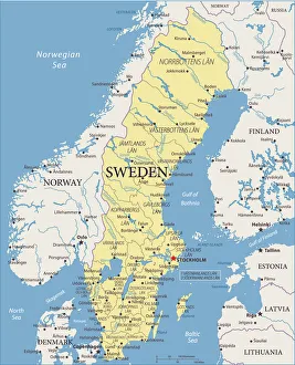
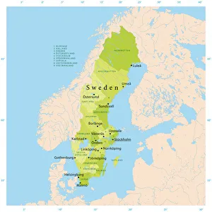
Map of Sweden - Vector illustration
Asia Map - illustrationColored Map of Asia with Country Names and Capital Cities The url of the reference to map is: http:/lib.utexas.edu/maps/world_maps/time_zones_ref_2011.pdf
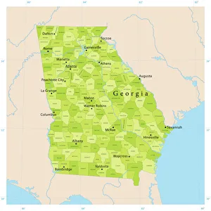
Georgia State Vector MapHighly detailed vector map of Georgia, United States. File was created on April 17, 2012. The colors in the.eps-file are ready for print (CMYK). Included files: EPS (v8) and Hi-Res JPG
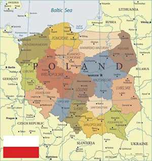
28 - Poland - Color2 10Map of Poland - Vector illustration
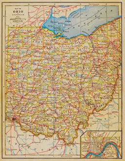
1883 Ohio State Map
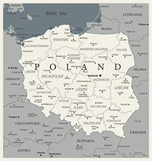
24 - Poland - Vintage Murena Isolated 10Map of Poland - Vintage Vector illustration
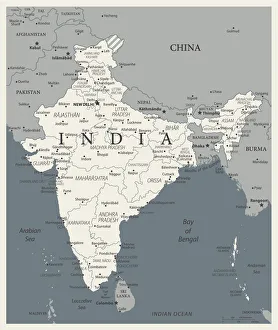
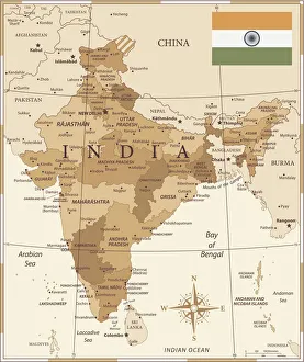
24 - India - Vintage Murena Isolated 10Map of India - Vintage Vector illustration
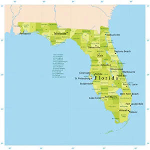
Florida Vector MapHighly detailed vector map of Florida, United States. File was created on January 23, 2012. The colors in the.eps-file are ready for print (CMYK). Included files: EPS (v8) and Hi-Res JPG
25 - India - Vintage Golden 10Map of India - Vintage Vector illustration
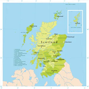
Scotland Vector MapHighly detailed vector map of Scotland. File was created on July 20, 2011. The colors in the.eps-file are ready for print (CMYK). Included files: EPS (v8) and Hi-Res JPG
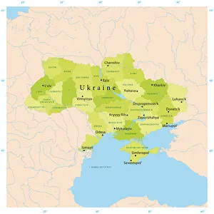
Ukraine Vector MapHighly detailed vector map of Ukraine. File was created on December 16, 2011. The colors in the.eps-file are ready for print (CMYK). Included files: EPS (v8) and Hi-Res JPG
Belgium Vector MapHighly detailed vector map of Belgium. File was created on July 14, 2011. The colors in the.eps-file are ready for print (CMYK). Included files: EPS (v8) and Hi-Res JPG
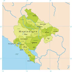
Montenegro Vector MapHighly detailed vector map of Montenegro. File was created on October 25, 2011. The colors in the.eps-file are ready for print (CMYK). Included files: EPS (v8) and Hi-Res JPG
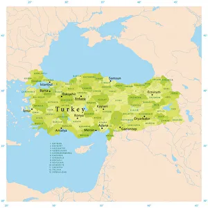
Turkey Vector MapHighly detailed vector map of Turkey. File was created on January 10, 2012. The colors in the.eps-file are ready for print (CMYK). Included files: EPS (v8) and Hi-Res JPG
Sweden Vector MapHighly detailed vector map of Sweden. File was created on November 14, 2011. The colors in the.eps-file are ready for print (CMYK). Included files: EPS (v8) and Hi-Res JPG
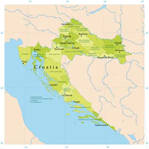
Croatia Vector MapHighly detailed vector map of Croatia. File was created on September 14, 2011. The colors in the.eps-file are ready for print (CMYK). Included files: EPS (v8) and Hi-Res JPG
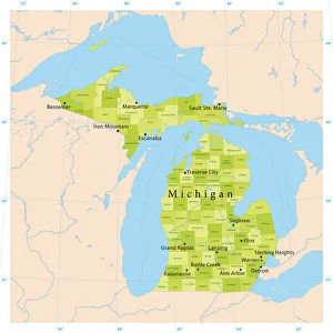
Michigan Vector MapHighly detailed vector map of Michigan, United States. File was created on November 14, 2012. The colors in the.eps-file are ready for print (CMYK)
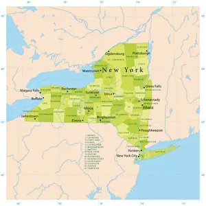
New York State Vector MapHighly detailed vector map of New York State, United States. File was created on January 24, 2012. The colors in the.eps-file are ready for print (CMYK). Included files: EPS (v8) and Hi-Res JPG
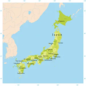
Japan Vector MapHighly detailed vector map of Japan. File was created on August 23, 2012. The colors in the.eps-file are ready for print (CMYK). Included files: EPS (v8) and Hi-Res JPG (5600 x 5600 px)
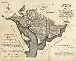
Early Map of the City and Capitol of Washington, D. C. United States, Antique American Illustration, 1900Antique American Photograph: Early Map of the City and Capitol of Washington, D.C. United States, Antique American Illustration, 1900: Original edition from my own archives
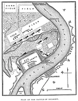
Battle of BelmontVintage engraving from 1863 of a map of the Battle of Belmont which was fought on November 7, 1861, in Mississippi County, Missouri. It was the first combat test in the American Civil War for Brig
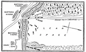
Battle of Big BethelVintage engraving from 1863 of a map of the Battle of Big Bethel also known as the Battle of Bethel Church or Great Bethel was an American Civil War battle that took place on June 10, 1861
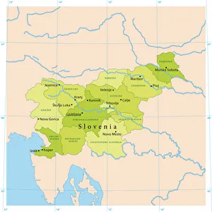
Slovenia Vector MapHighly detailed vector map of Slovenia. File was created on September 23, 2011. The colors in the.eps-file are ready for print (CMYK). Included files: EPS (v8) and Hi-Res JPG
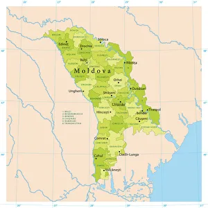
Moldova Vector MapHighly detailed vector map of Moldova. File was created on October 18, 2011. The colors in the.eps-file are ready for print (CMYK). Included files: EPS (v8) and Hi-Res JPG
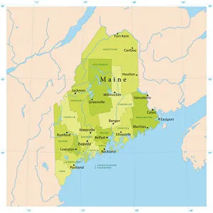
Maine Vector MapHighly detailed vector map of Maine, United States. File was created on January 27, 2012. The colors in the.eps-file are ready for print (CMYK). Included files: EPS (v8) and Hi-Res JPG
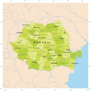
Romania Vector MapHighly detailed vector map of Romania. File was created on October 12, 2011. The colors in the.eps-file are ready for print (CMYK). Included files: EPS (v8) and Hi-Res JPG
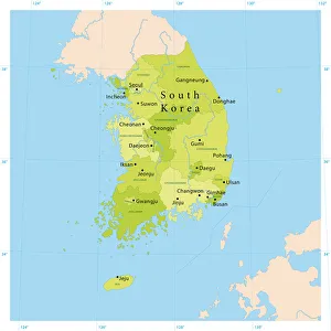
South Korea Vector MapHighly detailed vector map of South Korea. File was created on August 29, 2012. The colors in the.eps-file are ready for print (CMYK). Included files: EPS (v8) and Hi-Res JPG (5600 x 5600 px)
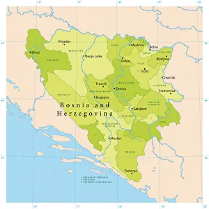
Bosnia Herzegovina Vector MapHighly detailed vector map of Bosnia and Herzegovina. File was created on October 11, 2011. The colors in the.eps-file are ready for print (CMYK). Included files: EPS (v8) and Hi-Res JPG
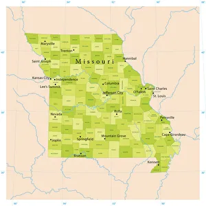
Missouri Vector MapHighly detailed vector map of Missouri, United States. File was created on April 19, 2012. The colors in the.eps-file are ready for print (CMYK). Included files: EPS (v8) and Hi-Res JPG
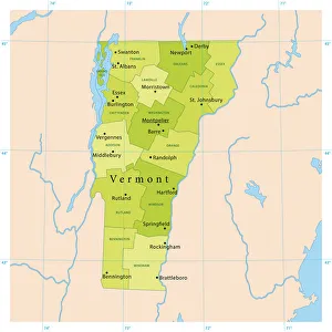
Vermont Vector MapHighly detailed vector map of Vermont, United States. Source data courtesy of NGDC (database: World Data Bank II), NASA (reference images: Blue Marble) and National Atlas (database)
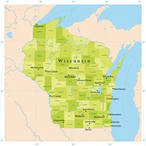
Wisconsin Vector MapHighly detailed vector map of Wisconsin, United States. Source data courtesy of NGDC (database: World Data Bank II), NASA (reference images: Blue Marble) and National Atlas (database)
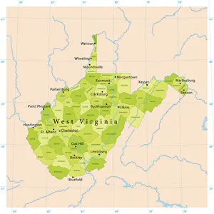
West Virginia Vector MapHighly detailed vector map of West Virginia, United States. Source data courtesy of NGDC (database: World Data Bank II), NASA (reference images: Blue Marble) and National Atlas (database)
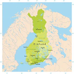
Finland Vector MapHighly detailed vector map of Finland. File was created on November 24, 2011. The colors in the.eps-file are ready for print (CMYK). Included files: EPS (v8) and Hi-Res JPG
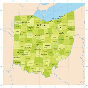
Ohio Vector MapHighly detailed vector map of Ohio, United States. File was created on November 16, 2012. The colors in the.eps-file are ready for print (CMYK)
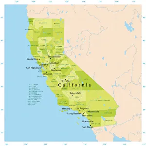
California Vector MapHighly detailed vector map of California, United States. File was created on January 18, 2012. The colors in the.eps-file are ready for print (CMYK). Included files: EPS (v8) and Hi-Res JPG
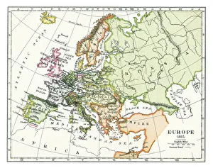
Old map of Europe in 1815Antique Illustration. Copyright has expired on this artwork. From my own archives, digitally restored
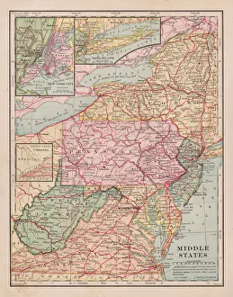
Middle states map 1898
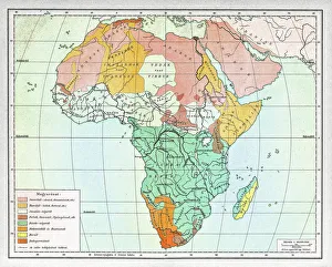
Ethnographic map of Africa from 1898Illustration of a Ethnographic map of Africa
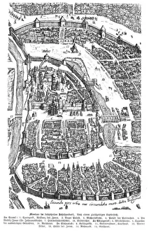
City of Moscow Russia 17th century map illustrationMoscow Russia 17th century Original edition from my own archives Source : Illustrierte Geschichte 1883