mail_outline sales@mediastorehouse.com
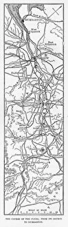
Map of the Course of the River Clyde, England Victorian Engraving, 1840Very Rare, Beautifully Illustrated Antique Engraving of Map of the Course of the River Clyde, England Victorian Engraving, 1840 from Our Own Country, Great Britain, Descriptive, Historical
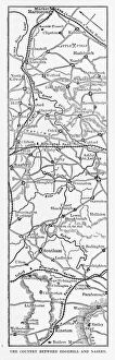
Map of Edgehill and Naseby, England Victorian Engraving, 1840Very Rare, Beautifully Illustrated Antique Engraving of Map of Edgehill and Naseby, England Victorian Engraving, 1840 from Our Own Country, Great Britain, Descriptive, Historical, Pictorial
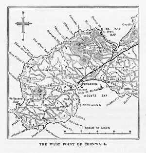
Map of Cornwall and Lands End, England Victorian Engraving, 1840Very Rare, Beautifully Illustrated Antique Engraving of Map of Cornwall and Lands End, England Victorian Engraving, Circa 1840 from Our Own Country, Great Britain, Descriptive, Historical, Pictorial
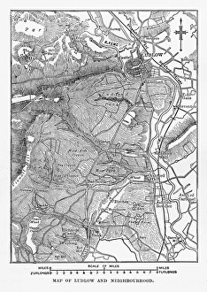
Map of Ludlow, England Victorian Engraving, Circa 1840Very Rare, Beautifully Illustrated Antique Engraving of Map of Ludlow, England Victorian Engraving, Circa 1840 from Our Own Country, Great Britain, Descriptive, Historical, Pictorial
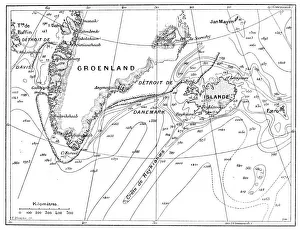
Antique illustration of Greenland and Iceland bathymetry map
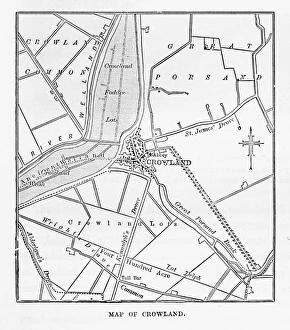
Map of Crowland, England Victorian Engraving, Circa 1840Very Rare, Beautifully Illustrated Antique Engraving of Crowland, The Cut at Peakirk Victorian Engraving from Our Own Country, Great Britain, Descriptive, Historical, Pictorial. Published in 1880
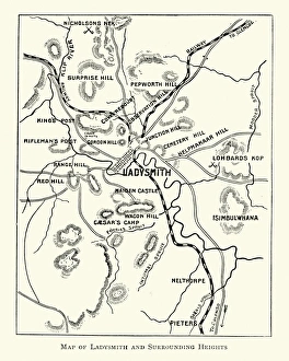
Second Boer War - Plan Ladysmith and surrounding heightsVintage engraving of a Plan Ladysmith and surrounding heights. 1899
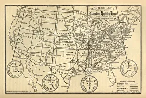
Engraved Chart of United States Time Zones, Circa 1883Beautifully Illustrated Antique Engraved Victorian Illustration of an Engraved Chart of United States Time Zones and Standard Railway Time, Circa 1883. Original edition from my own archives
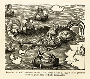
St. Brandans Celebration of the Holy Mass Engraving, Circa 1550Beautifully Illustrated Antique Engraved Victorian Illustration of St. Brandans Celebration of the Holy Mass on the Back of a Whale Engraving, Circa 1550
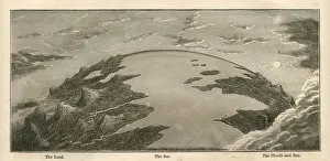
Topographical Land Sea Sky Earth Globe, Antique 1871 IllustrationColor stock photo of an antique illustration of a topographical earth globe showing land, sea and sky examples. Salvaged from an 1871 geography book
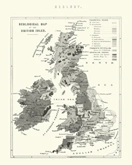
Victorian Geological Map of the British IslesVintage engraving of a Victorian Geological Map of the British Isles
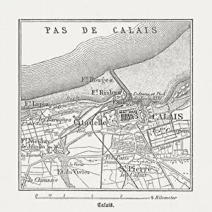
Calais, France, wood engraving, published in 1882City map of Calais, France. Wood engraving, published in 1882
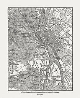
Budapest, wood engraving, published in 1882City map Budapest, capital of Hungary. Wood engraving, published in 1882
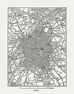
Brussels, Belgium, wood engraving, published in 1882Brussels, capital of Belgium. Wood engraving, published in 1882
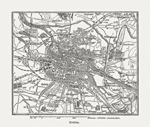
Breslau (Wrocaw, Poland), wood engraving, published in 1882Breslau (formerly German Empire), today Wrocaw, Poland. Wood engraving, published in 1882
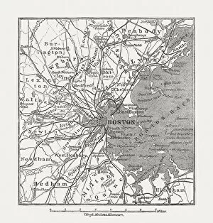
Boston, Massachusetts, USA, wood engraving, published in 1882Map of Boston, Massachusetts, USA. Wood engraving, published in 1882
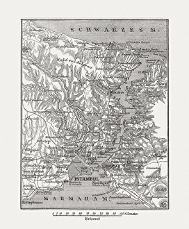
Map of Bosphorus, Turkey, wood engraving, published in 1882Map of Bosphorus and Istanbul, Turkey. Wood engraving, published in 1882
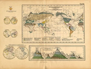
Map of Global Distribution of Plants, Victorian Botanical IllustrationVery Rare, Beautifully Illustrated Antique Engraved Victorian Botanical Illustration of Map of Global Distribution of Plants: Plate 60
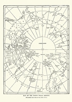
Victorian map of the North Polar RegionsVintage engraving showing a Victorian map of the North Polar Regions
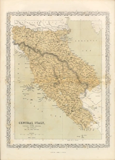
Victorian Map of Central Italy, Circa 1865Extremely Rare, Beautifully Illustrated Antique Victorian Engraved Illustration of the map of Central Italy including Tuscany, Parma and Modena from Liberators of Italy
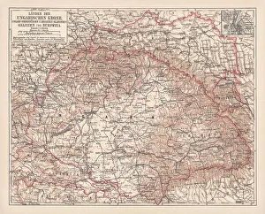
Hungary, lithograph, published in 1878Ancient map of Hungarian Monarchy, Galicia and Bukovina. Lithograph, published in 1878
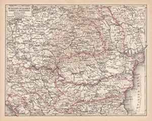
Balkan States, lithograph, published in 1878Ancient map of the Balkan States: Romania, Bulgaria, Serbia and Montenegro. Lithograph, published in 1878
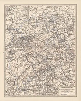
Prussian provinces, lithograph, published in 1878Prussian provinces: Rhineland, Westphalia, and Hesse-Nassau. Lithograph, published in 1878
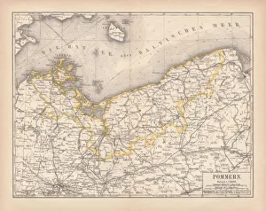
Pomerania, lithograph, lithograph, published in 1878Pomerania, former territory of the German Empire. Lithograph, published in 1878
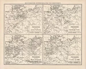
Historical development of Prussia, lithograph, published in 1878Ancient maps of the historical development of Prussia, 17th - 19th century. Lithograph, published in 1878
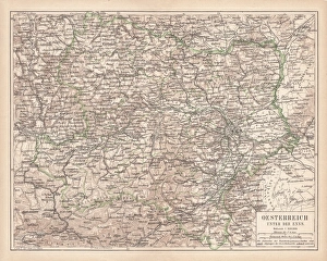
Lower Austria, lithograph, published in 1877Lower Austria (Austria below the Enns, A-sterreich unter der Enns). Lithograph, published in 1877
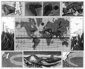
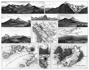
Volcanic and Hurricane Charts; Craters; and Antarctica EngravingEngraved Illustrations of Volcanic and Hurricane Charts; Craters; and Antarctica from Iconographic Encyclopedia of Science, Literature and Art, Published in 1851
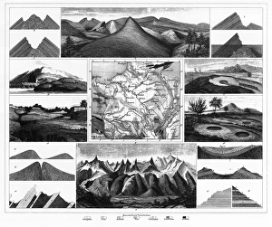
Stratification in Mountains and Basins; Fissures and Craters EngravingEngraved Illustrations of Stratification in Mountains and Basins; Fissures and Craters from Iconographic Encyclopedia of Science, Literature and Art, Published in 1851
Volcanoes and Volcanic Formations and Stratification EngravingEngraved Illustrations of Volcanoes and Volcanic Formations and Stratification from Iconographic Encyclopedia of Science, Literature and Art, Published in 1851. Copyright has expired on this artwork
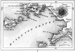
Map of Bay of Naples and Naples EngravingEngraved Illustrations of Volcanoes and Volcanic Formations and Stratification and the Map of Bay of Naples and Naples, Italy from Iconographic Encyclopedia of Science, Literature and Art
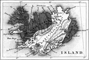
Map of Volcanic Chart of Iceland EngravingEngraved Illustrations of Volcanoes and Volcanic Formations and Stratification and the Map of Volcanic Chart of Iceland from Iconographic Encyclopedia of Science, Literature and Art
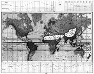
Historical Rainfall and Temperature Charts EngravingEngraved Illustrations of Historical Rainfall and Temperature Map; Temperature Charts of the World from Iconographic Encyclopedia of Science, Literature and Art, Published in 1851
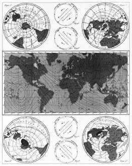
Climate and Weather Charts EngravingEngraved Illustrations of Climate and Weather Charts of the World from Iconographic Encyclopedia of Science, Literature and Art, Published in 1851. Copyright has expired on this artwork
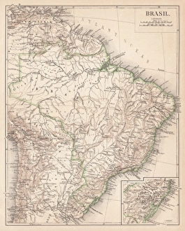
Map of Brazil. Lithograph, lithograph, published in 1874Antique map of Brazil. Lithograph, published in 1874
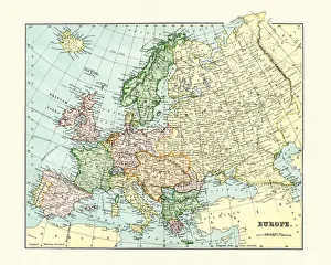
Antique Map of Europe 1880s
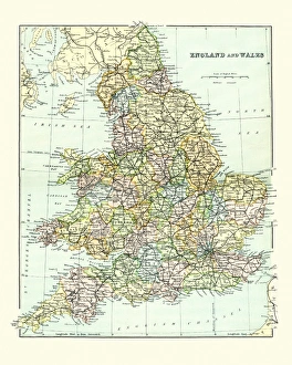
Antique Map of England and Wales 1880sVintage 19th Century map of England and Wales
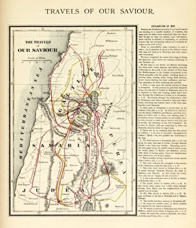
Travels of Our Savior Map EngravingEngraved illustration of the Travels of Our Savior Map Engraving from The Popular Pictorial Bible, Containing the Old and New Testaments, Published in 1862. Copyright has expired on this artwork
Alternating current generatorantique illustration of alternating generator, Electric rotary machine
Antique illustration of cartridge gun mechanism
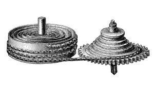
Antique illustration of clock gears
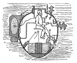
Antique illustration of Submarine section
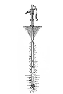
Antique illustration of water pump
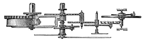
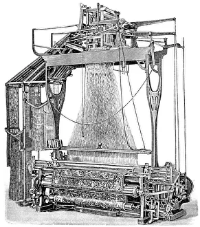
Textile / tapestry machineAntique illustration of machinery used in textile/tapestry industry isolated on white
Antique illustration of watch gears
Figs | Antique Design Illustrations19th-century engraving of figs (isolated on white)
Antique illustration of CannabisAntique engraving illustration of Cannabis
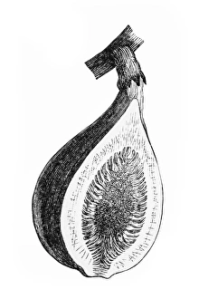
Antique illustration of fig section
Our Lady of Victory church in ViennaAntique illustration of Our Lady of Victory church which is one of the most impressive churches in Vienna