mail_outline sales@mediastorehouse.com
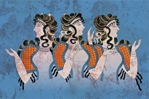
Fresco Three Minoan Women KnossosMinoan Fresco of the Ladies in Blue depicts the women in the open blouse that was typical in the later Minoan Culture. The fresco fragments were discovered during the excavation of a Minoan site in
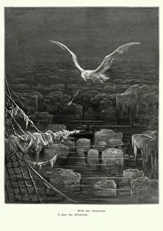
Rime of the Ancient Mariner - I shot AlbatrossVintage engraving by Gustave Dore of a scene from the Rime of the Ancient Mariner, With my crossbow I shot the Albatross. The Rime of the Ancient Mariner is the longest major poem by the English poet
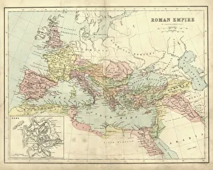
Antique map of the Roman Empire, with a detail on Rome
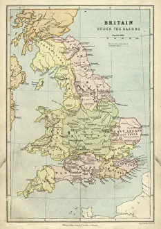
Antique map of Britain under the Anglo Saxons
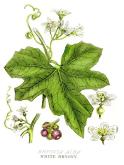
White bryony poison plant engraving 1857A History of the Vegetable Kingdom by Wlliiam Rhind 1855
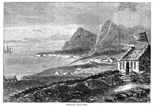
Tristan da CunhaVintage engraving from 1878 showing a view of Tristan da Cunha a remote volcanic group of islands in the south Atlantic Ocean and the main island of that group
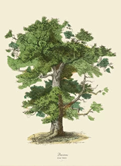
Oak Tree or Quercus, Victorian Botanical IllustrationVery Rare, Beautifully Illustrated Antique Engraved Victorian Botanical Illustration of Oak Tree or Quercus: Plate 43, from The Book of Practical Botany in Word and Image
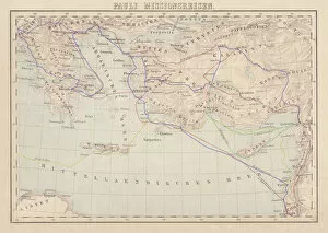
Apostle Pauls Missionary Journeys, lithograph, published in 1886Apostle Pauls Missionary Journeys: 1st (green); 2nd (red); 3rd (blue); last to Rome (yellow). Lithograph, published in 1886. Paul travelled over 10, 000 miles proclaiming the gospel of Jesus Christ
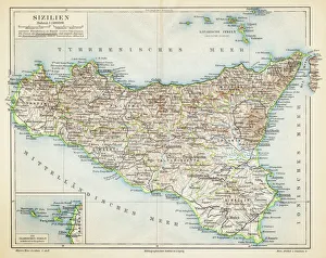
Sicily map 1895Meyers Konversations-Lexikon. Ein Nachschlagewerk des allgemeinen Wissens, 5th edition 17 volumes Bibliographisches Institut - Leipzig 1895-1897
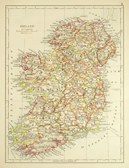
Map of Ireland 1897Map of Ireland
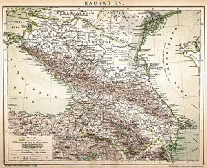
Old Caucasus mapAntique map of Caucasus
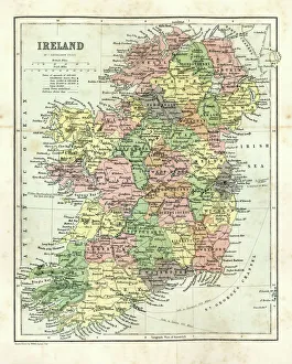
Antique map of Ireland, 1864
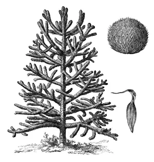
Monkey puzzle tree (araucaria imbricata)Illustration of a monkey puzzle tree (araucaria imbricata)
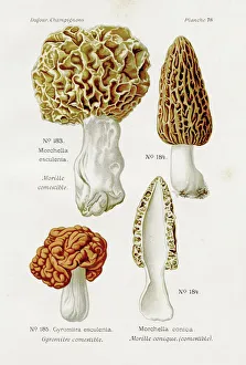
Morel mushroom 1891Atlas des Champignons, L. Dufour 1891
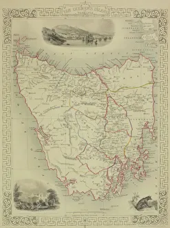
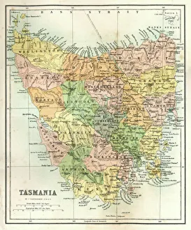
Antique map of Tasmania
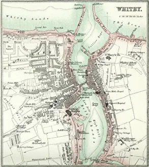
Map of WhitbyVintage map from 1880 of Whitby a town in North Yorkshire, England.++Inspector: Info about source material uploaded as property release++
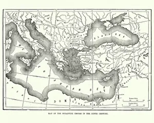
Map of the Byzantine Empire in the 9th CenturyVintage engraving of a Map of the Byzantine Empire in the 9th Century
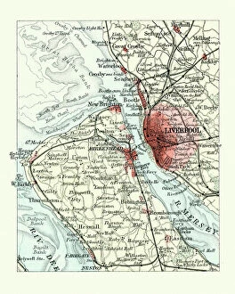
Antique map, Liverpool and Birkenhead, England, 19th CenturyVintage engraving of a Antique map, Liverpool and Birkenhead, England, 19th Century
Thylacinus cynocephalus (Tasmanian Tiger, Tasmanian Wolf, Thylacine)Illustration of a Thylacinus cynocephalus (Tasmanian Tiger, Tasmanian Wolf, Thylacine)
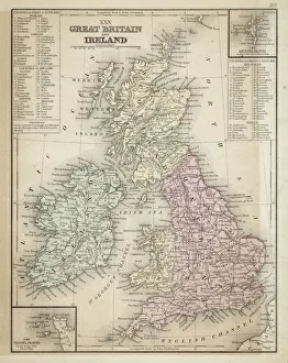
Great Britain and Ireland map 1867Mitchell's Modern Atlas - Published by E.H. Butler and Co - Philadelphia 1867
Human Anatomy - Backbone including Ribs and PelvisVintage engraving of the human Backbone including Ribs and Pelvis. 19th Century
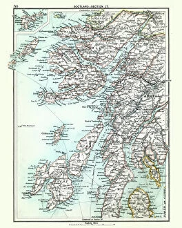
Antique map, Scotland, Jura, Mull, Argyll, Islay 19th CenturyVintage engraving of a Antique map, Scotland, Jura, Mull, Argyll, Islay 19th Century
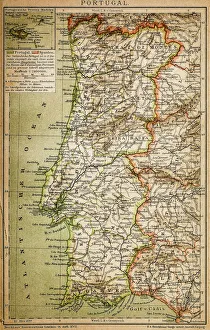
Map of PortugalAntique illustration engraving map og Portugal
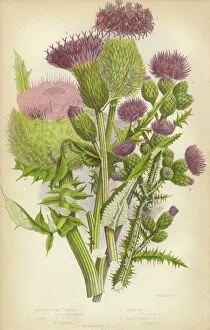
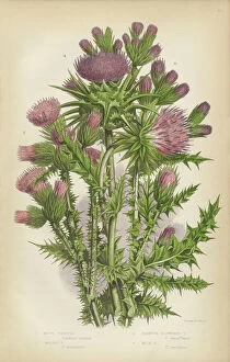
Thistle, Milk Thistle, Musk Thistle, Scotland, Victorian Botanical IllustrationVery Rare, Beautifully Illustrated Antique Engraved Thistle, Milk Thistle, Musk Thistle, Victorian Botanical Illustration Victorian Botanical Illustration
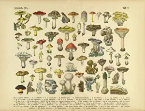
Poisonous Mushrooms, Victorian Botanical IllustrationVery Rare, Beautifully Illustrated Antique Engraved Victorian Botanical Illustration of Poisonous Mushrooms: Plate 9, from The Book of Practical Botany in Word and Image
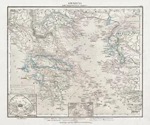
Greece at the beginning of the Peloponnesian War (431-404 BC)Antique Map of Greece at the beginning of the Peloponnesian War (431 - 404 BC) with the different tribal groups. Steel engraving with hand colored borderlines, published in 1861
Antique Map of TasmaniaAntique map of Tasmania from 1867
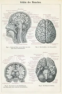
Brain anatomy engraving 1895Encyclopedia Britannica 9th Edition Vol I New York, Samuel Hall 1878
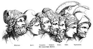
Heroes Of The Trojan WarIllustration of a Heroes Of The Trojan War
Roman Republic and Carthage during the Second Punic War (218-201-BC)Ancient map of the Roman Republic and Carthage during the Second Punic War (218 to 201 BC). Legend in Latin language. Steel engraving with hand colored borderlines, published in 1861
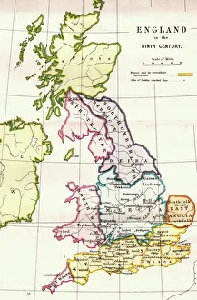
England in the Ninth CenturyAn antique map from 1875 showing the different kingdoms of England in the 9th century
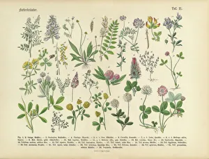
Herbs anb Spice, Victorian Botanical IllustrationVery Rare, Beautifully Illustrated Antique Engraved Victorian Botanical Illustration of Forage Herbs anb Spice: Plate 11, from The Book of Practical Botany in Word and Image
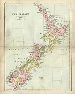
Antique map of New Zealand in the 19th Century, 1873Vintage engraving of a Antique map of New Zealand in the 19th Century, 1873
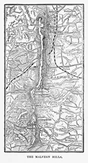
Map of Malvern Hills in Worcestershire, England Victorian Engraving, 1840Very Rare, Beautifully Illustrated Antique Engraving of Map of Malvern Hills in Worcestershire, England Victorian Engraving, 1840. Source: Original edition from my own archives
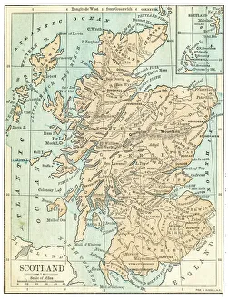
Scotland map 1875The Independent Course Comprehensive Geography by James Monteith, A.S. Barnes & Co, New York & Chicago 1875
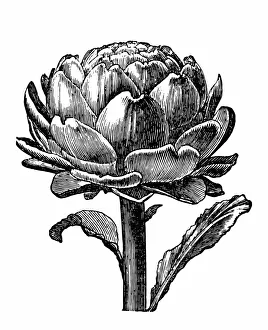
ArtichokeAntique engraving of an artichoke, isolated on white
Traditional Kuniyoshi Japanese Woodblock print of Actor" Utagawa Kuniyoshi 1797-1862 was one of the last great masters of the Japanese ukiyo-e style of woodblock prints he is associated with the Utagawa school
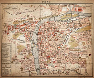
PragueAntique map of Prague from 1898
Vegetables, Fruit and Berries of the Garden, Victorian Botanical IllustrationVery Rare, Beautifully Illustrated Antique Engraved Victorian Botanical Illustration of Vegetables, Fruit and Berries of the Garden: Plate 50
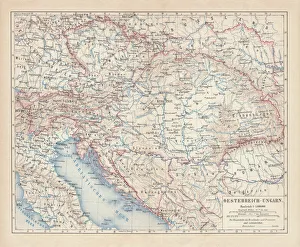
Austro-Hungarian Empire, Habsburg Monarchy, lithograph, published in 1877Ancient map of Austro-Hungarian Empire. Habsburg Monarchy. Lithograph, published in 1877
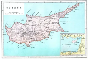
Map of CyprusVintage 19th Century map of Cyprus in the eastern Mediterranean Sea
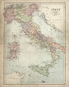
Antique Damaged Map of Italy 19th CenturyAntique damaged map of Italy 19th Century
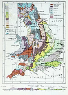
Antique colored illustrations: Geological map of England and Wales
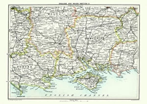
Map of South East England, Hampshire, Dorset, Wiltshire 1891Antique Map of Map of South East England, showing Hampshire, Dorset, Wiltshire, and the Isle of Wight 1891
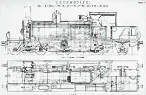
Old fashioned steam train locomotiveVintage engraving the plasn and diagram of an old fashioned steam train locomotive, the Bogie and radial tank engine by Neilson and Company of Gaslgow
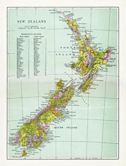
Antique Map of New ZealandVintage map of New Zealand, from 1894
Human Heart Anatomy 1888Illustrated Natural History of the Three Kingdoms Illustrierte Naturgeschichte der drei Reiche Franz StrAÔé¼ssles - Wilhelm Nitzschke, Stuttgart 1888