mail_outline sales@mediastorehouse.com
Musk Beetle -Aromia moschata-, Tyrol, Austria
Garden Loosestrife -Lysimachia vulgaris-, Tyrol, Austria
Little Grebe -Tachybaptus ruficollis-, juvenile, Tyrol, Austria
Praying Mantis -Mantis religiosa-, laying eggs in an ootheca, Burgenland, Austria
Eurasian Bittern or Great Bittern -Botaurus stellaris-, Burgenland, Austria
Pheasant -Phasianus colchicus-, cock displaying, Lower Austria, Austria
Marmot -Marmota marmota- nibbling on a peanut, Salzburger Land, Austria
Watercress -Nasturtium officinale-, Eggendorf, Lower Austria, Austria
Tulip Tree -Liriodendron tulipifera-, blossom, Salzburg, Salzburg State, Austria
Lake Leopoldsteinersee, Eisenerz, Styria, Austria
Alpine Anemone or Sulphur Anemone -Pulsatilla alpina ssp. Alpiifolia-, Kaunertal valley, Tyrol, Austria
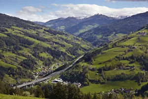
A10 Tauern Autobahn motorway, Liesertal valley, at Eisentratten, Carinthia, Austria
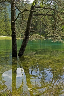
Gruner See or Green Lake, Tragoss, Styria, Austria
Battle Of LepantoThe allied Papal, Spanish, Venetian and Genoese fleets, under Don John of Austria, stand victorious over the Turks at the Battle of Lepanto (Navpaktos) on the 7th October, 1571
Hallstatt central plazaIn the centre of the square stands the mighty Holy Trinity statue, which after 6 years after erection experienced one of the Hallstatts greatest disasters
Hallstatt VillageHallstatt in Upper Austria, is a village in the Salzkammergut, a region in Austria. It is located near the HallstAÔé¼tter See
Doomed B-24circa 1944: A US Airforce B-24 Liberator bomber goes down in flames in a raid over Austria, during World War II. The American Airforce photographer who took the picture was quoted as saying I felt
antiquity, archival, austria, cartography, europe, france, french, geographical, geography, historical, landscape, lyons, map, nobody, old-fashioned, river, roads, scenic, vienna, vienne, vintage
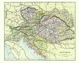
Antique Map of Austria Empire Late 19th CenturyAntique Map of Austria Empire in the Late 19th Century
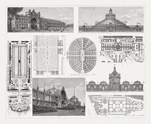
Exhibition buildings to world exhibitions in the 19th centuryExhibition buildings and floor plans of world exhibitions in the 19th century: 1) Paris 1855, Industry building; 2) Paris 1855, detail from the floor plan; 3) Paris 1867, floor plan; 4) Vienna 1873
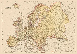
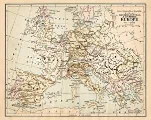
Map of Europe 1881Encyclopedia Britannica 9th Edition Vol XII Philadelphia j.M. Stoddart & Co 1881
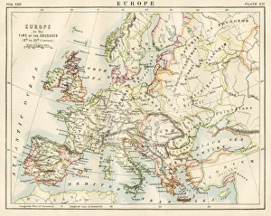
Europe time of the crusadesEncyclopedia Britannica 9th Edition Vol XII Philadelphia j.M. Stoddart & Co 1881
Europe map 1881Harpers School Geography, New York, Harpers and Brothers, 1881
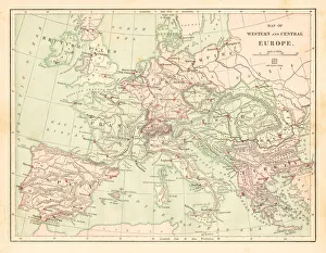
Western and Central Europe map 1881Harpers School Geography, New York, Harpers and Brothers, 1881
architecture, austria, bannister, building, central europe, color image, croppedWien, Bankgasse, Concordia-Haus
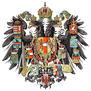
Empire of AustriaIllustration of a Empire of Austria
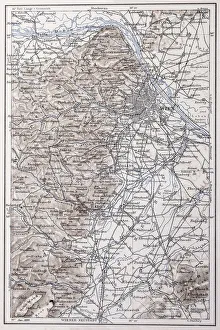
Vienna and surroundingsIllustration of a Vienna and surroundings
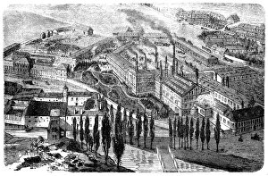
The beer brewery in Klein-Schwechat near Vienna from 1866illustration of a The beer brewery in Kleinschwechat near Vienna
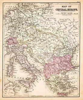
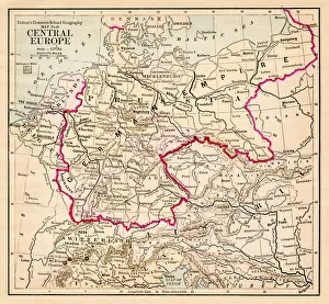
Map of Central Europe 1883Warrens Common School Geography
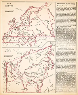
Map of Europe and asia 1883Warrens Common School Geography
Map of Europe 1883Warrens Common School Geography
Central Europe map 1881Coltons Common School Geography 1881 New York Sheldon and Co
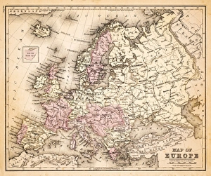
Europe map 1881Coltons Common School Geography 1881 New York Sheldon and Co
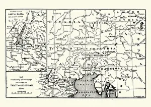
Map of the Campaign preceding the Treaty of Camp-formioVintage engraving of a Map of the Campaign preceding the Treaty of Camp-formio, 1797
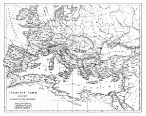
Victorian Map of The Roman EmpireEngraved illustrations of the Roman Empire Under Constantine the Great from Iconographic Encyclopedia of Science, Literature and Art, Published in 1851. Copyright has expired on this artwork
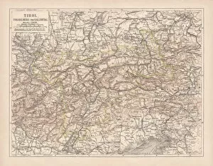
Tirol, Vorarlberg and Salzburg in Austria, lithograph, published in 1878Ancient map of Tirol, Vorarlberg and Salzburg in Austria. Lithograph, published in 1878
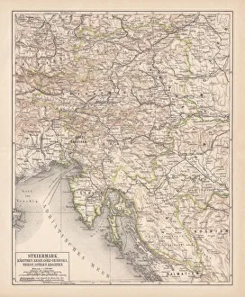
Styria, lithograph, published in 1878Ancient map of Styria: Carinthia, Carniola, GradiAaka, Croatia, Istria, Triest. Lithograph, published in 1878
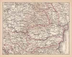
Balkan States, lithograph, published in 1878Ancient map of the Balkan States: Romania, Bulgaria, Serbia and Montenegro. Lithograph, published in 1878
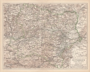
Upper Austria, lithograph, published in 1877Upper Austria (Austria above the Enns, A-sterreich ob der Enns). Lithograph, published in 1877
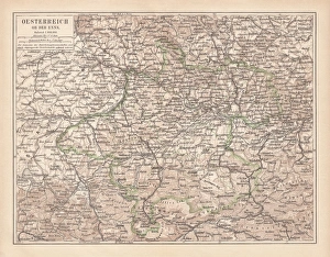
Lower Austria, lithograph, published in 1877Lower Austria (Austria below the Enns, A-sterreich unter der Enns). Lithograph, published in 1877
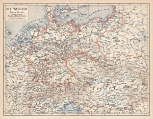
German Empire of 1871-1918, lithograph, published in 1875German Empire within the borders of 1871 - 1918. Lithograph, published in 1875
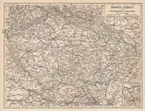
Bohemia, Moravia, Austria and Silesia, lithograph, published in 1874Bohemia, Moravia, Austria and Silesia. Lithograph, published in 1874
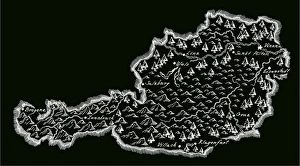
Antique AustriaAustria Map, - Antique style. Includes mountains and water bodies. High detail - vector illustration
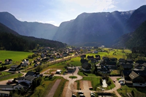
Obertraun Village, AustriaThe aerial view of Obertraun village
Panorana of Lake HallstAÔé¼tterseeThe aerial view of Lake HallstAÔé¼ttersee
Lake HallstatterseeThe aerial view of Lake Hallstattersee
Hallstatt in morning time, AustriaTonnaja Travel Photography, 670625770