mail_outline sales@mediastorehouse.com
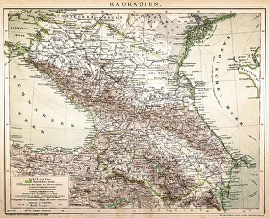
Old Caucasus mapAntique map of Caucasus
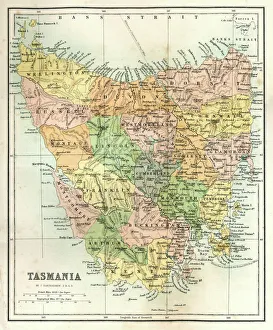
Antique Map of TasmaniaAntique map of Tasmania from 1867
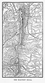
Map of Malvern Hills in Worcestershire, England Victorian Engraving, 1840Very Rare, Beautifully Illustrated Antique Engraving of Map of Malvern Hills in Worcestershire, England Victorian Engraving, 1840. Source: Original edition from my own archives
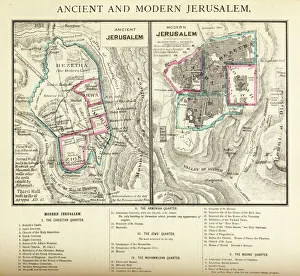
Ancient and Modern Jerusalem Map EngravingEngraved illustration of Ancient and Modern Jerusalem Map Engraving from The Popular Pictorial Bible, Containing the Old and New Testaments, Published in 1862. Copyright has expired on this artwork
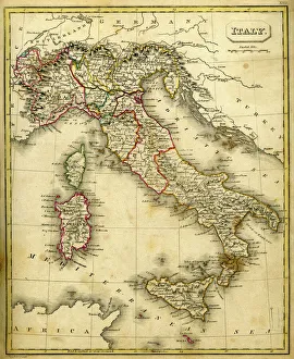
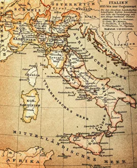
Antquie Map of ItalyVintage map of Italy fron 1837
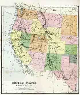
Antique Map of Western USAAntique Map from 1867 of Western United States of America
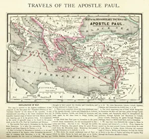
Travels of The Apostle Paul Map EngravingEngraved illustration of the Travels of The Apostle Paul Map Engraving from The Popular Pictorial Bible, Containing the Old and New Testaments, Published in 1862
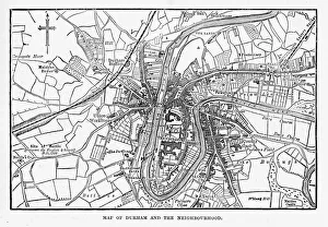
Map of the City of Durham, England Victorian Engraving, 1840Very Rare, Beautifully Illustrated Antique Engraving of Map of the City of Durham, England Victorian Engraving, 1840. Source: Original edition from my own archives
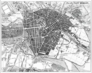
Berlin, Germany MapEngraved illustrations of a Map of the City of Berlin, Germany from Iconographic Encyclopedia of Science, Literature and Art, Published in 1851. Copyright has expired on this artwork
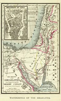
Wanderings of the Israelites Map EngravingEngraved illustration of Wanderings of the Israelites Map Engraving from The Popular Pictorial Bible, Containing the Old and New Testaments, Published in 1862. Copyright has expired on this artwork
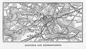
Map of Litchfield in Staffordshire, England Victorian Engraving, 1840Very Rare, Beautifully Illustrated Antique Engraving of Map of Litchfield in Worcestershire, England Victorian Engraving, 1840. Source: Original edition from my own archives
Seamless Astronomical Constellation Night Sky PatternSimple, modern seamless astronomy patterned background with major star captions against a night sky and galaxy
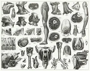
Anatomy of Organs EngravingEngraved illustrations of Anatomy of the Fasciae, Integuents, and Organs of Mastication and Respiration from Iconographic Encyclopedia of Science, Literature and Art, Published in 1851
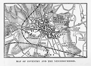
Map of Coventry in Warwickshire, England Victorian Engraving, 1840Very Rare, Beautifully Illustrated Antique Engraving of Map of Coventry in Warwickshire, England Victorian Engraving, 1840. Source: Original edition from my own archives
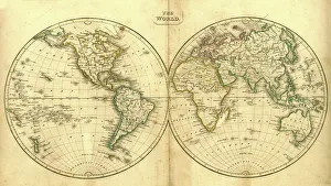
Vintage Map of the WorldVintage map of the world from 1837
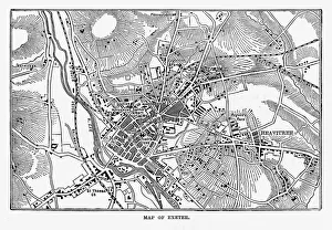
Map of Exeter in Devon, England Victorian Engraving, 1840Very Rare, Beautifully Illustrated Antique Engraving of Map of Exeter in Devon, England Victorian Engraving, 1840. Source: Original edition from my own archives
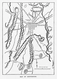
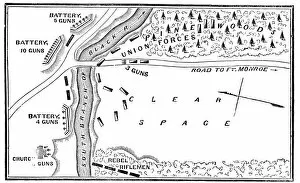
Battle of Gettysburg Map, July 3, 1863 Civil War EngravingEngraving of the Map of the Battle of Gettysburgs, Pennsylvania, July 3, 1863 Civil War Engraving from Famous Leaders and Battle Scenes of the Civil War, Published in 1864
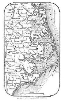
Map of Pamlico and Albemarle SoundsVintage engraving from 1863 of a map of Map of Pamlico and Albemarle Sounds at the time of the American Civil War
Antquie Map of ItalyVintage map of Italy from 1815
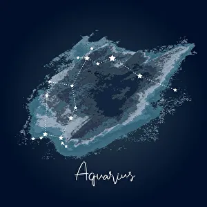
Modern Night Sky Constellation - AquariusSimple, modern depiction of a celestial constellation on a navy backdrop. Aquarius is located near other water-related constellations: Cetus (the whale), Pisces (the fish)
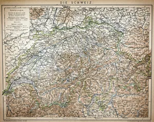
Antique Map of Switzerland from 1898
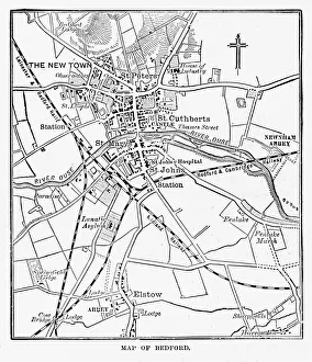
Map of the City of Bedford, England Victorian Engraving, 1840Very Rare, Beautifully Illustrated Antique Engraving of Map of the City of Bedford, England Victorian Engraving, 1840. Source: Original edition from my own archives
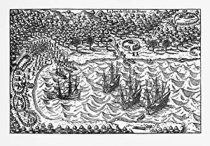
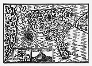
Island of Principe Historical Map by Van Noort, Circa 1598Very Rare, Beautifully Illustrated Antique Engraved Victorian Illustration of Historical Map of Van Noort at the Island of Principe, 1598. Copyright has expired on this artwork. Digitally restored
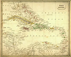
Antquie Map of The West IndiesVintage map of The West Indies from 1837
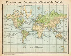
Commercial chart of the world map 1875The Independent Course Comprehensive Geography by James Monteith, A.S. Barnes & Co, New York & Chicago 1875
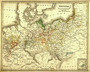
Antquie Map of PrussiaVintage map of Prussia from 1837
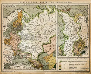
Historic map of RussiaIllustration of a historic map of Russia
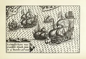
Engraving of Van Noort Landing in Manila Bay, Philippines, 1600Very Rare, Beautifully Illustrated Antique Engraved Victorian Illustration of Historical Engraving of Van Noort Landing in Manila Bay, Philippines, 1600. Copyright has expired on this artwork
Historical Map of Dutch Navigators Island of Bali IllustrationVery Rare, Beautifully Illustrated Antique Engraved Victorian Illustration of Historical Map of Dutch Navigators on the Island of Bali. Copyright has expired on this artwork. Digitally restored
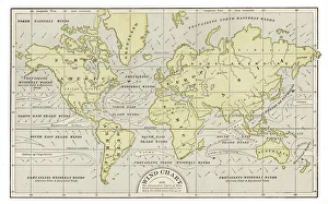
Wind chart map 1889Indiana Educational Series The Complete Geography - Indianapolis 1889
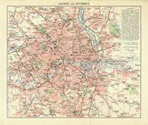
London and Environs Historical Map, Engraving, 1892Very rare, beautifully detailed engraving of London and Environs Historical Map, Engraving, Published in 1892. Original edition from my own archives. Copyright has expired on this artwork
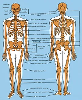
Diagram of a Skeletonhttp://csaimages.com/images/istockprofile/csa_vector_dsp.jpg
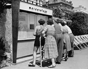
Eastbourne Holiday WeatherJune 1950: Holidaymakers studing the meteorology charts on the seafront at Eastbourne, East Sussex. (Photo by Fox Photos/Getty Images)
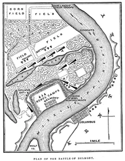
Battle of BelmontVintage engraving from 1863 of a map of the Battle of Belmont which was fought on November 7, 1861, in Mississippi County, Missouri. It was the first combat test in the American Civil War for Brig
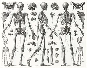
Human Skeleton EngravingEngraved illustrations of Anatomy of the Bones from Iconographic Encyclopedia of Science, Literature and Art, Published in 1851. Copyright has expired on this artwork. Digitally restored
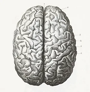
Human Brain EngravingEngraved illustrations of Anatomy of the Brain and Nerves from Iconographic Encyclopedia of Science, Literature and Art, Published in 1851. Copyright has expired on this artwork. Digitally restored
Human anatomyhttp://csaimages.com/images/istockprofile/csa_vector_dsp.jpg
Simple, modern depiction of a celestial constellation - VirgoSimple, modern depiction of a celestial constellation on a navy backdrop. Virgo is the largest constellation of the Zodiac and the second-largest constellation overall, behind Hydra
Modern Night Sky Constellation - Canis MajorSimple, modern depiction of a celestial constellation. The constellation Canis Major is located in the southern hemisphere of the sky
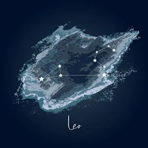
Modern Night Sky Constellation - LeoSimple, modern depiction of a celestial constellation on a navy backdrop. Leo constellation lies in the northern sky and is one of the zodiac constellations
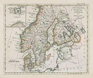
Antique map of Denmark, Norway, Sweden and FinlandWonderful hand coloured antique map, circa 1780 - 1800
Battle of Big BethelVintage engraving from 1863 of a map of the Battle of Big Bethel also known as the Battle of Bethel Church or Great Bethel was an American Civil War battle that took place on June 10, 1861
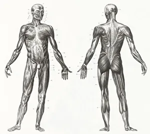
Human Muscles and Ligaments EngravingEngraved illustrations of Anatomy of the Ligaments and Muscles from Iconographic Encyclopedia of Science, Literature and Art, Published in 1851. Copyright has expired on this artwork
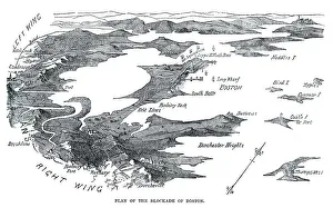
Blockade of BostonVintage engraving from 1861 showing the Plan of the Blockade of Boston during the American Revolutionary War
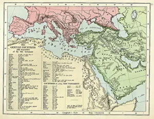
Old Testament MapVintage biblical map from 1879 showing the gentile countries and nations of the Old Testament
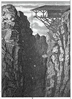
Persberg Mines, SwedenEngraved illustrations of Mining from Iconographic Encyclopedia of Science, Literature and Art, Published in 1851. Copyright has expired on this artwork. Digitally restored
Abstract Presentationhttp://csaimages.com/images/istockprofile/csa_vector_dsp.jpg
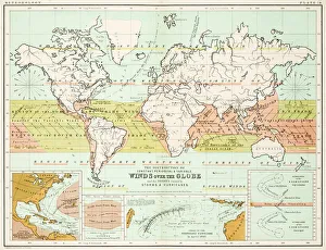
Winds - Map of the world 1861Map of the world - Winds over the globe - storms and hurricanes