mail_outline sales@mediastorehouse.com
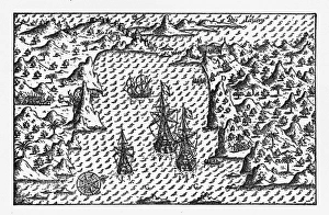
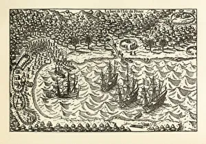
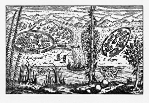
Rio de Janeiro Historical Map by Van Noort, Circa 1598Very Rare, Beautifully Illustrated Antique Engraved Victorian Illustration of Historical Map of Van Noort at Rio de Janeiro, 1598. Copyright has expired on this artwork. Digitally restored
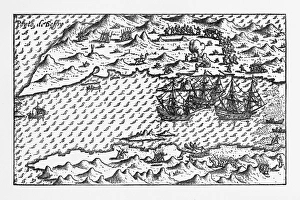
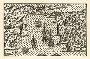
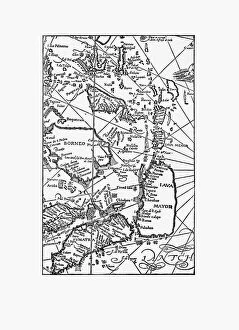
Van Noort at Porto Deseado Historical Map of 1598Very Rare, Beautifully Illustrated Antique Engraved Victorian Illustration of Historical Map of Van Noort at Porto Deseado, 1598. Copyright has expired on this artwork. Digitally restored
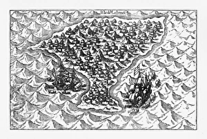
Porto Deseado Historical Map by Van Noort, Circa 1598Very Rare, Beautifully Illustrated Antique Engraved Victorian Illustration of Historical Map of Van Noort at Porto Deseado, 1598. Copyright has expired on this artwork. Digitally restored
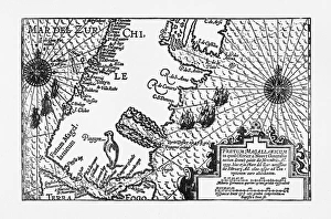
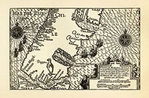
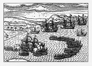
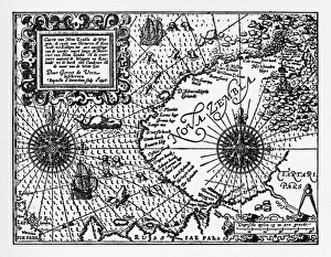
Strait of Magellan Map by Van Noort, Circa 1599Very Rare, Beautifully Illustrated Antique Engraved Victorian Illustration of Historical Map of Van Noort at the Strait of Magellan, 1599. Copyright has expired on this artwork. Digitally restored
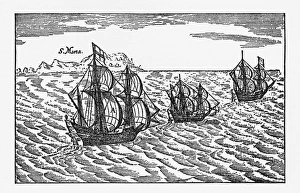
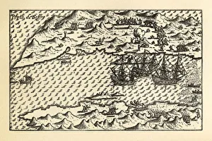
Van Noort Sailing the Strait of Magellan, Engraving of 1600Very Rare, Beautifully Illustrated Antique Engraved Victorian Illustration of Historical Engraving of Van Noort Sailing the Strait of Magellan, 1600. Copyright has expired on this artwork
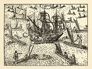
Van Noort Sailing the Marianne Islands, Engraving 1600Very Rare, Beautifully Illustrated Antique Engraved Victorian Illustration of Historical Engraving of Van Noort Sailing the Marianne Islands, 1600. Copyright has expired on this artwork
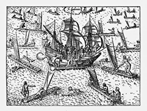
Theives Attacking Van Noort on the Marianne Islands, 1600Very Rare, Beautifully Illustrated Antique Engraved Victorian Illustration of Historical Engraving of Van Noort Attacked by Thieives on the Marianne Islands, 1600
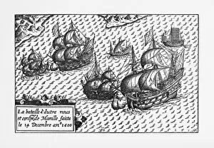
Van Noort Landing in Manila Bay, Philippines Engraving, 1600Very Rare, Beautifully Illustrated Antique Engraved Victorian Illustration of Historical Engraving of Van Noort Landing in Manila Bay, Philippines, 1600. Copyright has expired on this artwork
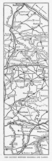
Map of Edgehill and Naseby, England Victorian Engraving, 1840Very Rare, Beautifully Illustrated Antique Engraving of Map of Edgehill and Naseby, England Victorian Engraving, 1840 from Our Own Country, Great Britain, Descriptive, Historical, Pictorial
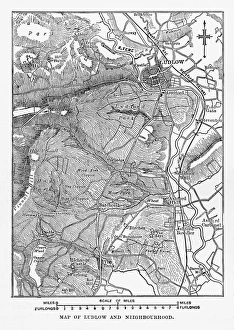
Map of Ludlow, England Victorian Engraving, Circa 1840Very Rare, Beautifully Illustrated Antique Engraving of Map of Ludlow, England Victorian Engraving, Circa 1840 from Our Own Country, Great Britain, Descriptive, Historical, Pictorial
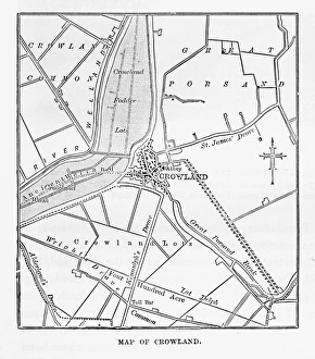
Map of Crowland, England Victorian Engraving, Circa 1840Very Rare, Beautifully Illustrated Antique Engraving of Crowland, The Cut at Peakirk Victorian Engraving from Our Own Country, Great Britain, Descriptive, Historical, Pictorial. Published in 1880
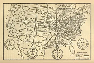
Engraved Chart of United States Time Zones, Circa 1883Beautifully Illustrated Antique Engraved Victorian Illustration of an Engraved Chart of United States Time Zones and Standard Railway Time, Circa 1883. Original edition from my own archives
Van Noort Attacked by Theives on the Marianne Islands, 1600Very Rare, Beautifully Illustrated Antique Engraved Victorian Illustration of Historical Engraving of Van Noort Attacked by Thieives on the Marianne Islands, 1600
Map of Van Noort at the Strait of Magellan, 1599Very Rare, Beautifully Illustrated Antique Engraved Victorian Illustration of Historical Map of Van Noort at the Strait of Magellan, 1599. Copyright has expired on this artwork. Digitally restored
Historical Map of Van Noort at Porto Deseado, 1598Very Rare, Beautifully Illustrated Antique Engraved Victorian Illustration of Historical Map of Van Noort at Porto Deseado, 1598. Copyright has expired on this artwork. Digitally restored
Historical Map of Van Noort at Rio de Janeiro, 1598Very Rare, Beautifully Illustrated Antique Engraved Victorian Illustration of Historical Map of Van Noort at Rio de Janeiro, 1598, from The Golden Book of the Dutch Navigators
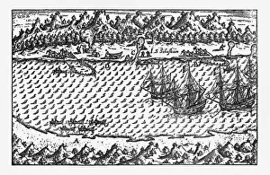
Historical Map of Van Noort at the Island of Principe, 1599Very Rare, Beautifully Illustrated Antique Engraved Victorian Illustration of Historical Map of Van Noort at the Island of Principe, from The Golden Book of the Dutch Navigators
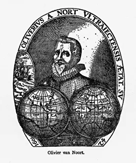
Oliver Van Noort Dutch Navigator, Victorian Illustration, 1558-1622Very Rare, Beautifully Illustrated Antique Engraved Victorian Illustration of Oliver Van Noort Dutch Navigator, Victorian Illustration, 1558-1622. Copyright has expired on this artwork
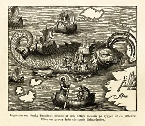
St. Brandans Celebration of the Holy Mass Engraving, Circa 1550Beautifully Illustrated Antique Engraved Victorian Illustration of St. Brandans Celebration of the Holy Mass on the Back of a Whale Engraving, Circa 1550
Historical Map of Dutch Navigators Battle in Portugal IllustrationVery Rare, Beautifully Illustrated Antique Engraved Victorian Illustration of Historical Map of Dutch Navigators Battle in Portugal Illustration. Copyright has expired on this artwork
Historical Map of Dutch Navigators Expedition to Sumatra IllustrationVery Rare, Beautifully Illustrated Antique Engraved Victorian Illustration of Historical Map of Dutch Navigators Expedition to Sumatra. Copyright has expired on this artwork. Digitally restored
Historical Map of Dutch Navigators Artic ExpeditionVery Rare, Beautifully Illustrated Antique Engraved Victorian Illustration of Historical Map of Dutch Navigators Arctic Expedition. Copyright has expired on this artwork. Digitally restored
Early Map of Dutch Navigation, Victorian IllustrationVery Rare, Beautifully Illustrated Antique Engraved Victorian Illustration of Early Map of Dutch Navigation. Copyright has expired on this artwork. Digitally restored
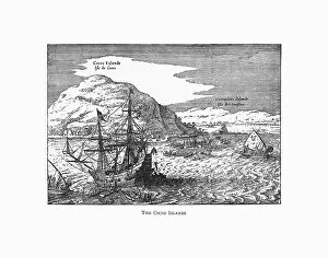
The Cocos Islands Dutch Navigation, Victorian IllustrationVery Rare, Beautifully Illustrated Antique Engraved Victorian Illustration of The Cocos Islands. Copyright has expired on this artwork. Digitally restored
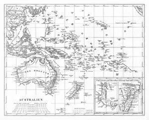
Victorian Map of AustraliaEngraved illustrations of the Map of Australia from Iconographic Encyclopedia of Science, Literature and Art, Published in 1851. Copyright has expired on this artwork. Digitally restored
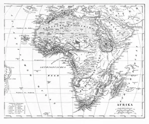
Victorian Map of AfricaEngraved illustrations of a Map of Africa from Iconographic Encyclopedia of Science, Literature and Art, Published in 1851. Copyright has expired on this artwork. Digitally restored
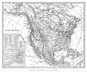
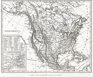
Map of North AmericaEngraved illustrations of a Map of North America from Iconographic Encyclopedia of Science, Literature and Art, Published in 1851. Copyright has expired on this artwork. Digitally restored
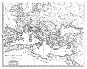
Victorian Map of The Roman EmpireEngraved illustrations of the Roman Empire Under Constantine the Great from Iconographic Encyclopedia of Science, Literature and Art, Published in 1851. Copyright has expired on this artwork
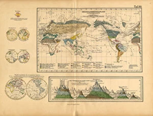
Map of Global Distribution of Plants, Victorian Botanical IllustrationVery Rare, Beautifully Illustrated Antique Engraved Victorian Botanical Illustration of Map of Global Distribution of Plants: Plate 60
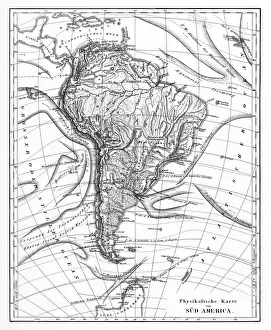
Victorian Map of North AmericaEngraved illustrations of the Physical Map of South America from Iconographic Encyclopedia of Science, Literature and Art, Published in 1851. Copyright has expired on this artwork. Digitally restored
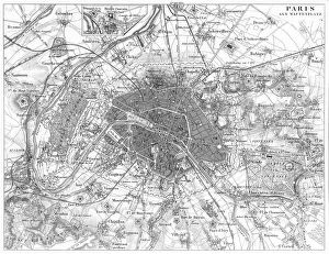
Fortifications of Paris Map EngravingEngraved illustrations of the Fortifications of Paris from Iconographic Encyclopedia of Science, Literature and Art, Published in 1851. Copyright has expired on this artwork. Digitally restored
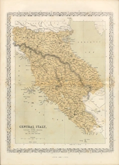
Victorian Map of Central Italy, Circa 1865Extremely Rare, Beautifully Illustrated Antique Victorian Engraved Illustration of the map of Central Italy including Tuscany, Parma and Modena from Liberators of Italy
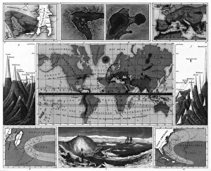
Volcanic and Hurricane Charts; Craters; and Antarctica EngravingEngraved Illustrations of Volcanic and Hurricane Charts; Craters; and Antarctica from Iconographic Encyclopedia of Science, Literature and Art, Published in 1851
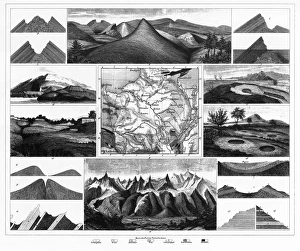
Stratification in Mountains and Basins; Fissures and Craters EngravingEngraved Illustrations of Stratification in Mountains and Basins; Fissures and Craters from Iconographic Encyclopedia of Science, Literature and Art, Published in 1851
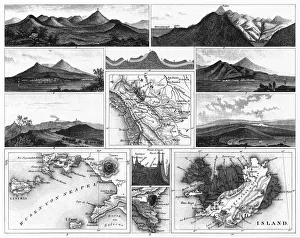
Volcanoes and Volcanic Formations and Stratification EngravingEngraved Illustrations of Volcanoes and Volcanic Formations and Stratification from Iconographic Encyclopedia of Science, Literature and Art, Published in 1851. Copyright has expired on this artwork
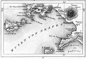
Map of Bay of Naples and Naples EngravingEngraved Illustrations of Volcanoes and Volcanic Formations and Stratification and the Map of Bay of Naples and Naples, Italy from Iconographic Encyclopedia of Science, Literature and Art
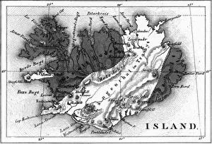
Map of Volcanic Chart of Iceland EngravingEngraved Illustrations of Volcanoes and Volcanic Formations and Stratification and the Map of Volcanic Chart of Iceland from Iconographic Encyclopedia of Science, Literature and Art
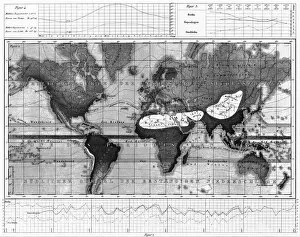
Historical Rainfall and Temperature Charts EngravingEngraved Illustrations of Historical Rainfall and Temperature Map; Temperature Charts of the World from Iconographic Encyclopedia of Science, Literature and Art, Published in 1851
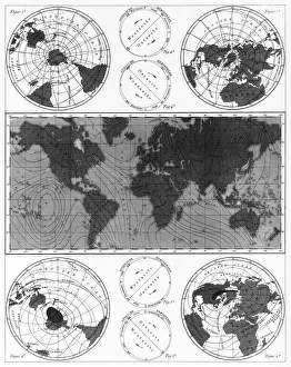
Climate and Weather Charts EngravingEngraved Illustrations of Climate and Weather Charts of the World from Iconographic Encyclopedia of Science, Literature and Art, Published in 1851. Copyright has expired on this artwork
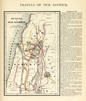
Travels of Our Savior Map EngravingEngraved illustration of the Travels of Our Savior Map Engraving from The Popular Pictorial Bible, Containing the Old and New Testaments, Published in 1862. Copyright has expired on this artwork
North America 1850 EngravingEngraved illustrations of the Physical Map of North America from Iconographic Encyclopedia of Science, Literature and Art, Published in 1851. Copyright has expired on this artwork. Digitally restored
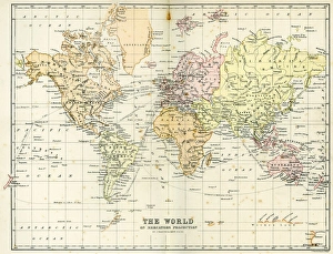
Antique Map of the WorldVintage map of the World from 1884
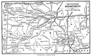
Missouri CampaignsVintage engraving from 1863 of a map of the Missouri Campaigns from the time of the American Civil War
Vintage Map of New York at the beginning of the 18th Century. from 1880
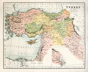
Antique Map of TurkeyAntique map of Turkey from 1867
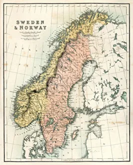
Antique Map of Sweden and NorwayAntique map of Sweden and Norway from 1867
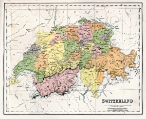
Antique Map of SwitzerlandAntique map of Switzerland from 1867
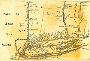
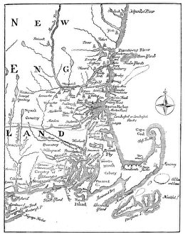
Vintage Map of New England at the beginning of the 18th century