mail_outline sales@mediastorehouse.com
Giant Rhubarb -Gunnera manicata-, Pumalin Park, Chaiten, Los Lagos Region, Chile
South America 1852 Map
South America political map 1895Meyers Konversations-Lexikon. Ein Nachschlagewerk des allgemeinen Wissens, 5th edition 17 volumes Bibliographisches Institut - Leipzig 1895-1897
Puyehue volcano in the evening light, Puyehue, Los Lagos Region, Chile
Osorno volcano, at the front a Chilean Firebush, also Notro or Ciruelillo -Embothrium coccineum-, Puerto Varas, Los Lagos Region, Chile
Dried seaweed, Puerto Montt, Los Lagos Region, Chile
Poplars, the Chilean Andes at the back, on the Rio Chacabuco river, Cochrane, Region de Aysen, Patagonia, Chile, South America, America
South America Map Illustration, Travel, Exploration, Antique 1871 IllustrationColor stock photo of an antique South America map illustration. Salvaged from an 1871 geography book
Illustration of national flag of Chile, with two equal horizontal bands of white and red five-pointed white star in centre of blue square at hoist
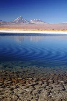
Pond in the Atacama Desert in Chileatacama desert, calm, chile, copy space, day, natural, nature, nobody, outdoor, peaceful, picturesque, pond, quiet, scenic, serene, shore, south america, tranquility, valley, Atacama Desert Valley
Map of South America 1895The Rand-McNally Grammar School Geography 1895 - Chicago & New York
Map of South America 1877Warrens Common School Geography 1877
Map of South America 19th CenturyVintage map of South America from the 19th Century
Vintage Map of North and South America534055040
chile, color image, cuernos del paine, day, extreme terrain, high angle view, horizontalchile, color image, cuernos del paine, day, extreme terrain, high ang, Gallo Landscapes, 106676668
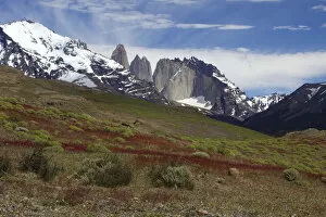
andes, beauty in nature, blue sky, chile, color image, colour image, copy space, dayandes, beauty in nature, blue sky, chile, color image, colour image, c, Gallo Landscapes, 137926213
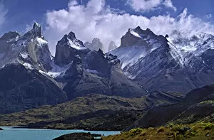
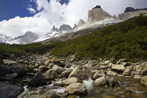
andes, beauty in nature, blue sky, chile, cloud, color image, copy space, cuernos del paineandes, beauty in nature, blue sky, chile, cloud, color image, copy spa, Gallo Landscapes, 137926260
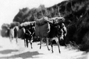
archival, black & white, blur, blurred, blurry, c, carrying, chile, donkeys, historicalarchival, black & white, blur, blurred, blurry, c, carrying, chile, donk, Vintage Black & White, 86481742
Engraving: South AmericaEngraved illustrations of South America from Iconographic Encyclopedia of Science, Literature and Art, Published in 1851. Copyright has expired on this artwork. Digitally restored
Polyandria Monogynia Victorian Botanical Illustration, Azara, Toothed Azara, 1835Very Rare, Beautifully Illustrated Antique Engraved and Hand Colored Victorian Botanical Illustration of Azara, Toothed Azara, Polyandria Monogynia Victorian Botanical Illustration, 1835, Plants
Azara, Toothed Azara, Polyandria Monogynia Victorian Botanical Illustration, 1835Very Rare, Beautifully Illustrated Antique Engraved and Hand Colored Victorian Botanical Illustration of Azara, Toothed Azara, Polyandria Monogynia Victorian Botanical Illustration, 1835, Plants
Amrican Native People, lithograph, published in 1897Amrican Native People: 1) Aleutian people; 2) Tlingit people (Koloschen, Koloshi); 3 - 4) Eskimos, man and wife; 5) Kowitschin people, Vancouver, Britisch-Columbia); 6) Absarokee (Crow Nation)
The Continent of South America, Circa 1850Engraved illustrations of the Map of South America from Iconographic Encyclopedia of Science, Literature and Art, Published in 1851. Copyright has expired on this artwork. Digitally restored
Chile map 1897The World-Wide Atlas of Modern Geography, Political and Physical W. & A.K. Johnston - London 1897
South America map 1893Johnsonas Universal Cyclopedia - Charles Kendall - New York 1893
Argentina, Chile, Bolivia, Uruguay, and Paraguay, lithograph, published in 1897Argentina, Chile, Bolivia, Uruguay, and Paraguay. Lithograph, published in 1897
South America map 1881Harpers School Geography, New York, Harpers and Brothers, 1881
Yareta or Llareta cushion plant -Azorella compacta-, Putre, Arica and Parinacota Region, Chile
Monkey puzzle tree -Araucaria araucana-, Conguillio National Park, Melipeuco, Region de la Araucania, Chile
Temperate rain forest on a mountain pass, Cisnes, Aysen Province, Chile
Patagonia fox, ChileAlert Paragonian grey fox (Pseudalopex griseus) small canid known as zorro, resting on gravel but looking around for birds, small mammals and other prey, close up, fall
Map of Brazil and Paraguay (early 19th century steel engraving)A steel engraving of a map from the early 19th century of Brazil and Paraguay in South America, from A System of Geography, Popular and Scientific, or A Physical, Political
Map of South America (early 19th century steel engraving)A steel engraving of a map from the early 19th century of Brazil and Paraguay in South America, from A System of Geography, Popular and Scientific, or A Physical, Political
Antquie Map of South AmericaVintage map of South America from 1837