mail_outline sales@mediastorehouse.com
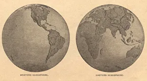
Old, Map of Eastern and Western Hemispheres, From 1875Old black and white illustration of the Eastern Hemisphere and the Western Hemisphere, from the 1800 s
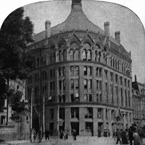
architecture, archival, black & white, board of trade, building, c, canada, caucasianVintage image of Board of Trade building in Toronto, Canada
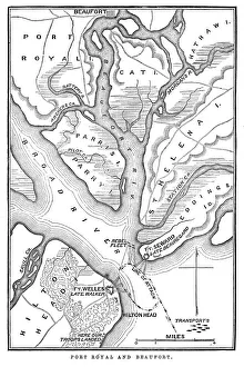
Battle of Port RoyalVintage engraving from 1863 of a map of the Battle of Port Royal which was one of the earliest amphibious operations of the American Civil War
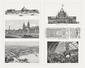
Buildings of the world Exhibitions, 19th centuryExhibition buildings of world exhibitions in the 19th century: 1-3) Buildings for the World Exhibition 1893 in Chicago, USA: 1) Machine exhibition building, 2) Building for horticulture
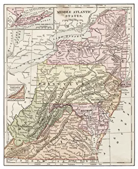
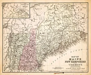
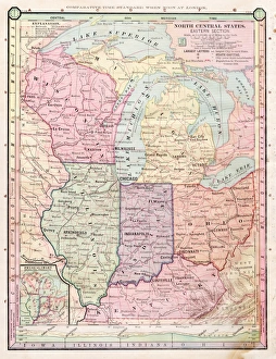
Middle Atlantic states 1889Indiana Educational Series The Complete Geography - Indianapolis 1889
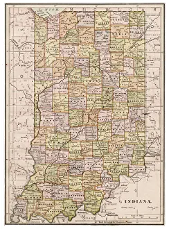
Map of Indiana 1889Indiana Educational Series The Complete Geography - Indianapolis 1889
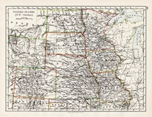
United States NW Central 1897The World-Wide Atlas of Modern Geography, Political and Physical W. & A.K. Johnston - London 1897
Harlequin Duck on a mid-stream rockHarlequin Duck (Histrionicus histrionicus), female watches as a male stretches its wings before entering the water of LeHardy Rapids, Yellowstone National Park, Wyoming
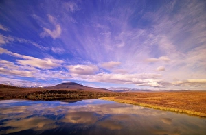
Canada, Yukon Territory, Dempster Highway, clouds reflected on lakeAutumn. John Eastcott and Yva Momatiuk Photography, 10183732
Montana. Feral horse breed is found in Mexico and plains of western North Americaau0555-001
Moose bull (Alces alces) water dripping from head and antlersDenali National Park, Alaska, USA
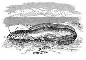
Clarias anguillaris, catfish also known as the mudfishAntique illustration engraving of Clarias anguillaris, catfish also known as the mudfish
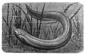
The South American lungfish (Lepidosiren paradoxa)Antique illustration engraving of The South American lungfish (Lepidosiren paradoxa)
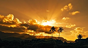
Hanalei Bay Sunset over Palm Trees Kauai HawaiiSunset over the sea, Hanalei Bay, Kauai, Hawaii. God Rays and Sun Beams shining over the landscape. Kauai, Hawaii
Man standing in desert silhouetteMan silhouetted and walking below hills of the Nevada desert at sunsest
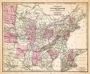
Map of Railroads USA 1883Warrens Common School Geography
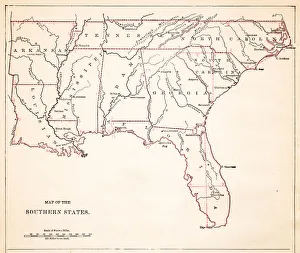
Drawing Map of Southern states USA 1883Warrens Common School Geography
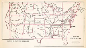
Map of United States 1883Warrens Common School Geography
Map of New Hampshire USA 1883Warrens Common School Geography
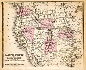
Map of Pacific states USA 1883Warrens Common School Geography
North Central states map 1886North Central states map Maps Monteith Physical Geography 1886
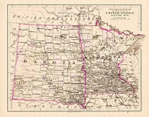
North Dakota and MInnesota map 1881Coltons Common School Geography 1881 New York Sheldon and Co
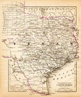
Texas map 1881Coltons Common School Geography 1881 New York Sheldon and Co
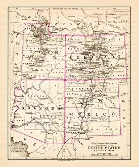
Utah Arizona New Mexico Colorado map 1881Coltons Common School Geography 1881 New York Sheldon and Co
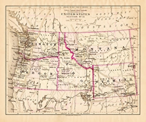
Montana Washington Oregon Idaho map 1881Coltons Common School Geography 1881 New York Sheldon and Co
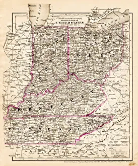
indiana Ohio Kentucky map 1881Coltons Common School Geography 1881 New York Sheldon and Co
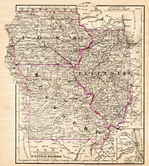
Iowa Missouri Illinois map 1881Coltons Common School Geography 1881 New York Sheldon and Co
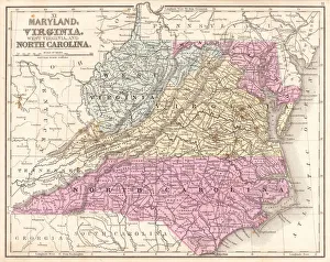
Map of Maryland Virginia North Carolina 1867Mitchells Modern Atlas - Published by E.H. Buttler & Co - Philadelphia 1867
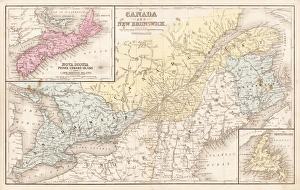
Map of Canada and New Brunswick 1867Mitchells Modern Atlas - Published by E.H. Buttler & Co - Philadelphia 1867
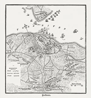
Battle of Yorktown in 1781, wood engraving, published in 1884Plan of the Battle of Yorktown during the American Revolutionary War in 1781. Wood engraving, published in 1884
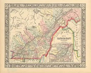
Victorian Map of Eastern Canada Circa 1850Engraved illustration of a Map of Eastern Canada in counties from Iconographic Encyclopedia of Science, Literature and Art, Published in 1851. Copyright has expired on this artwork. Digitally restored
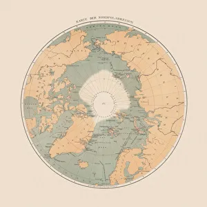
Ancient map of the Arctic Region, lithograph, published in 1883Ancient map of the Arctic Region. Lithograph, published in 1883
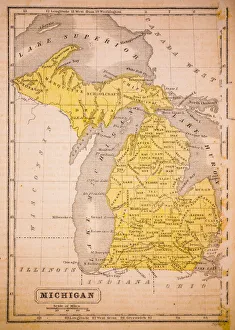
Michigan 1852 Map
Antquie Map of the United StatesVintage map of the United States of America from 1837
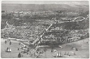
Chicago before the Great City Fire in 1871, published 1872Birds eye view of Chicago before the Great City Fire in 1871. Legend: 1) West-side, 2) Union-park, 3) Gasworks, 4) Lincoln-park, 5) Washington-place, 6) Promenade, 7) North-side, 8) Waterworks
Antique Map of Eastern USAAntique Map from 1867 of Eastern United States of America
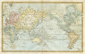
map of the world 1823map of the world - 1823 very detailed lithography
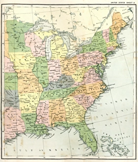
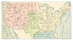
United States map 1875The Independent Course Comprehensive Geography by James Monteith, A.S. Barnes & Co, New York & Chicago 1875
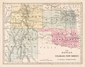
Kansas Colorado New Mexico map 1867Mitchellas Modern Atlas - Published by E.H. Butler and Co - Philadelphia 1867
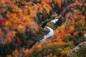
Lake of the Clouds in Peak Fall ColorCarp River running through the silhouettes of the ancient Porcupine Mountains in Fall Color, the Lake of the Clouds is a blue gem amid the thick forests
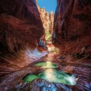
Dream Canyon, The Subway, Zion National Park UtahThe Subway is a colloquial name for a uniquely shaped slot canyon in Zion National Park. It is located between two peaks called the North and South Guardian Angels
Hydes Mill in Fall ColorsWisconsins roads along miles and miles of magnificent scenery through deep woods, broad vistas from high ridges and rock bluffs over deep clear brooks
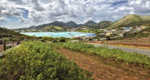
Pinel Island Pinel Bay Saint Martin Sint Maarten CaribbeanA dramatic view of the Pinel Bay, Pinel Island, ilet de Pinel, Petite Clef, Rue de Grande Caye as seen from a high vantage point. Island of Saint Martin Sint Maarten, Caribbean
Canyon of the Gods, Subway, Zion National Park, UTVivid color in a tight canyon with stream running through. The Subway, Left fork of North Creek, Zion Natioanl Park, Utah
Illustration, Aztec warrior in armour carrying yellow-green and red dotted shield, spear and oak broadsword
Illustration, standing Coyote (Canis latrans), front view
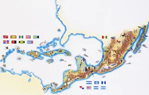
Map of Mexico, Central America and Caribbean
Illustration of Channel catfish (Ictalurus punctatus), North American freshwater fish