mail_outline sales@mediastorehouse.com
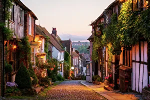
Mermaid Street, Rye, Sussex, England
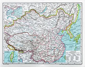
China mapillustration of a South Eastern Asia map
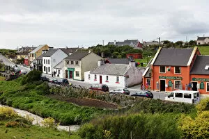
Fisher Street, Doolin, County Clare, Ireland, Europe
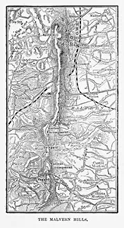
Map of Malvern Hills in Worcestershire, England Victorian Engraving, 1840Very Rare, Beautifully Illustrated Antique Engraving of Map of Malvern Hills in Worcestershire, England Victorian Engraving, 1840. Source: Original edition from my own archives
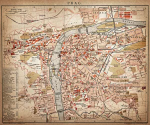
PragueAntique map of Prague from 1898
Highly detailed USA Road MapHighly detailed map of United States with roads, states, big cities, rivers and some other objects
Art deco buildings in Miami Beach
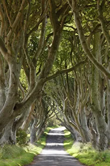
Dark Hedges, an avenue of Beech trees, Bregagh Road near Armoy, County Antrim, Northern Ireland, Great Britain, Europe
Pentonville Road, London, with St Pancras Station in the background. Original Artwork: Painting by John O Connor (Photo by Hulton Archive/Getty Images)
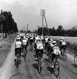
Tour De France, August 195118th August 1951: A group of contestants racing in the Tour de France. Original Publication: Picture Post - 5381 - The Greatest Show On Earth - pub
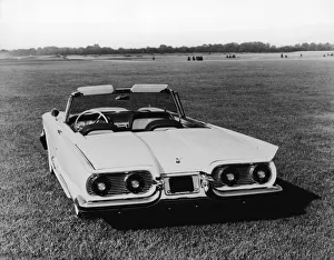
1959 Ford ThunderbirdView of a 1959 Ford Thunderbird motor car, its convertible roof in the down position, parked outside on a grassy field, 1959. (Photo by FPG/Getty Images)
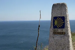
Finisterre - Camino de Santiago de CompostelaKm 0, 0 Finisterre last destination of Santiago de Compostela way
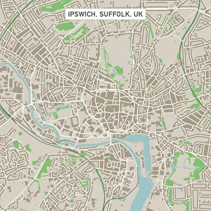
Ipswich Suffolk UK City Street MapVector Illustration of a City Street Map of Ipswich, Suffolk, UK. Included files are EPS (v10) and Hi-Res JPG. Data courtesy from Ordnance Survey: VectorMap District https
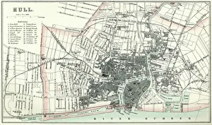
Map of HullVintage map from 1880 of Hull in the East Riding of Yorkshire, England. The city of Hull has served as market town, military supply port, trading hub, fishing and whaling centre
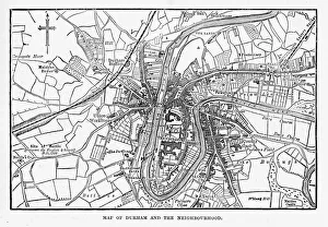
Map of the City of Durham, England Victorian Engraving, 1840Very Rare, Beautifully Illustrated Antique Engraving of Map of the City of Durham, England Victorian Engraving, 1840. Source: Original edition from my own archives
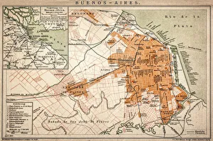
Buenos Aires mapAntique engraving map of Buenos Aires
Colosseum reflected at sunrise, Rome, ItalyThe Colosseum (Flavian Amphitheatre) at sunrise, still illuminated by artificial light. Rome, Italy
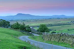
Ingleborough & Penyghent mountains vistaA distant view of two iconic hills in Yorkshire, part of the 3 peaks walk. Viewed from the Bowland forest area
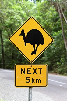
Cassowary warning sign in the rainforest, Daintree National Park, northern Queensland, Australia
The pass road leading up to Col de la Madeleine, the snow-capped peaks of the Mont Blanc Massif at the back, Alps, France
Isle of Man TT4th June 1913: Tom Peek on a Peelers and W Creyton on an Ariel passing through Kirk Michael village during the Isle of Man Tourist Trophy Race. (Photo by Topical Press Agency/Getty Images)
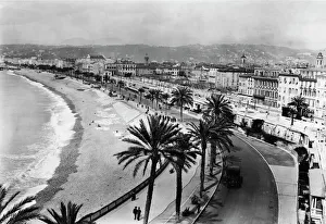
Nice RivieraThe Nice riviera, in southern France, April 1922. The seafront at the little town of Nice became known as " La Promenade des Anglais"
Donkey in front of blue domed church, Santorini
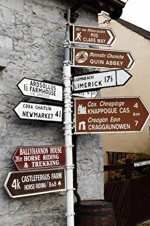
Signpost in Quin, County Clare, Ireland, Europe
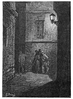
Victorian London - A shady placeVintage engraving showing a scene from 19th Century London England. A dark alley in Whitechapel circa 1870
Monumental Arch, Palmyra, SyriaSunset at the Unesco World heritage Site. Before the Syrian conflict started in 2011, more than 150, 000 tourists visited the city of Palmyra every year
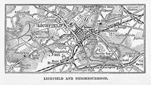
Map of Litchfield in Staffordshire, England Victorian Engraving, 1840Very Rare, Beautifully Illustrated Antique Engraving of Map of Litchfield in Worcestershire, England Victorian Engraving, 1840. Source: Original edition from my own archives
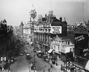
Watch This SpaceOctober 1919: Tottenham Court Road at the junction with Oxford Street and Charing Cross Road, London. The Court Playhouse is on the right, and the Underground station in front
View of the Col du Galibier mountain pass, Savoie, France
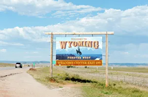
Welcome sign on a highway, Welcome to Wyoming, Forever West, flat landscape, Wyoming, USA
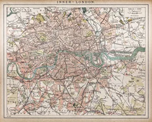
Historic map of London (18th Century)map/plan of the inner city of London from 1898
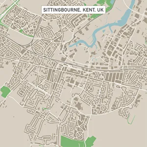
Sittingbourne Kent UK City Street MapVector Illustration of a City Street Map of Sittingbourne, Kent, UK. Included files are EPS (v10) and Hi-Res JPG. Data courtesy from Ordnance Survey: VectorMap District https
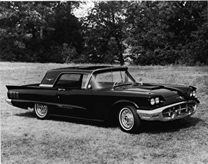
1960 Ford ThunderbirdView of a 1960 Ford Thunderbird motor car parked outisde on the grass, 1960. (Photo by FPG/Getty Images)
Pueblo Colorado US City Street MapVector Illustration of a City Street Map of Pueblo, Colorado, USA. Scale 1:60, 000. All source data is in the public domain. U.S
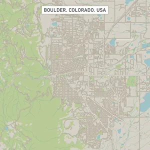
Boulder Colorado US City Street MapVector Illustration of a City Street Map of Boulder, Colorado, USA. Scale 1:60, 000. All source data is in the public domain. U.S
Minneapolis Minnesota US City Street MapVector Illustration of a City Street Map of Minneapolis, Minnesota, USA. Scale 1:60, 000. All source data is in the public domain. U.S
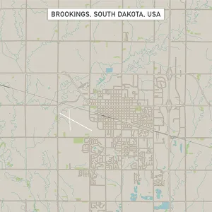
Brookings South Dakota US City Street MapVector Illustration of a City Street Map of Brookings, South Dakota, USA. Scale 1:60, 000. All source data is in the public domain. U.S
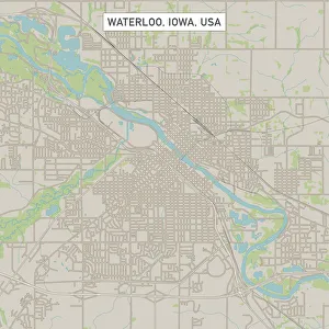
Waterloo Iowa US City Street MapVector Illustration of a City Street Map of Waterloo, Iowa, USA. Scale 1:60, 000. All source data is in the public domain. U.S
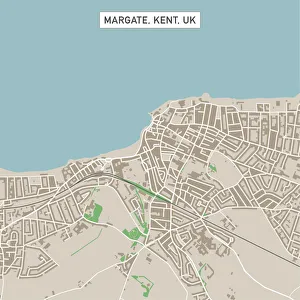
Margate Kent UK City Street MapVector Illustration of a City Street Map of Margate, Kent, UK. Included files are EPS (v10) and Hi-Res JPG. Data courtesy from Ordnance Survey: VectorMap District https
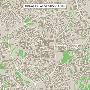
Crawley West Sussex UK City Street MapVector Illustration of a City Street Map of Crawley, West Sussex, UK. Included files are EPS (v10) and Hi-Res JPG. Data courtesy from Ordnance Survey: VectorMap District https
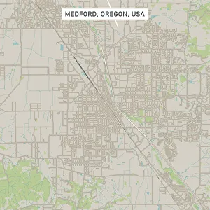
Medford Oregon US City Street MapVector Illustration of a City Street Map of Medford, Oregon, USA. Scale 1:60, 000. All source data is in the public domain. U.S
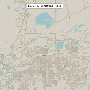
Casper Wyoming US City Street MapVector Illustration of a City Street Map of Casper, Wyoming, USA. Scale 1:60, 000. All source data is in the public domain. U.S
Waianapanapa SunriseThe Road to Hana is an amazing and probably Mauis most popular drive. One of the must stops on the way is the black sand beach. The water is cold, treacherous and shark infested
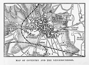
Map of Coventry in Warwickshire, England Victorian Engraving, 1840Very Rare, Beautifully Illustrated Antique Engraving of Map of Coventry in Warwickshire, England Victorian Engraving, 1840. Source: Original edition from my own archives
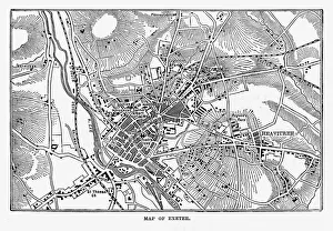
Map of Exeter in Devon, England Victorian Engraving, 1840Very Rare, Beautifully Illustrated Antique Engraving of Map of Exeter in Devon, England Victorian Engraving, 1840. Source: Original edition from my own archives
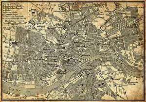
Map of Newcastle Upon TyneAntique illustration of old Newcastle Upon Tyne map
Tromso, NorwayCity of Tromso and Norwegian Sea taken from an aerial point of view
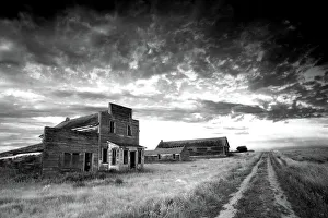
Prairie Ghost Town in Black and WhiteA ghost town on the plains. Dramatic landscape image in black and white. This image taken in the great plains in an abandoned town. Saskatchewan, Canada. Western faAzade on the old store