mail_outline sales@mediastorehouse.com
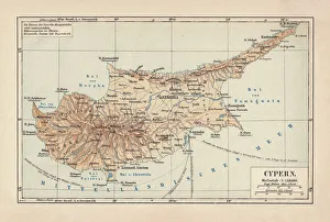
Map of Cyprus, published in 1880Ancient map of Cyprus. Lithograph, published in 1880
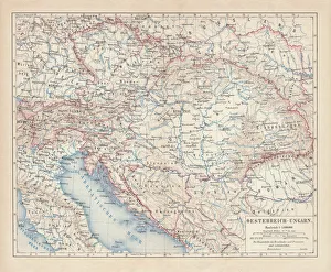
Austro-Hungarian Empire, Habsburg Monarchy, lithograph, published in 1877Ancient map of Austro-Hungarian Empire. Habsburg Monarchy. Lithograph, published in 1877
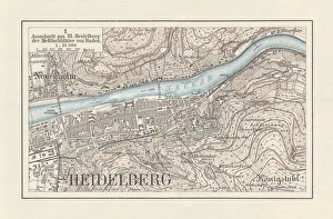
Historical city map of Heidelberg, Baden-WAOErttemberg, Germany, lithograph, published 1897Historical city map of Heidelberg, Baden-WAOErttemberg, Germany. Lithograph, published in 1897
City map of Paris, lithograph, published in 1877City map of Paris, France. Lithograph, published in 1877
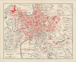
City map of Rome, lithograph, published in 1878City map of Rome, Italy. Lithograph, published in 1878
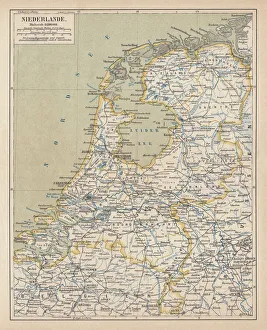
Map of the Netherlands, lithograph, published in 1877Map of the Netherlands. Lithograph, published in 1877
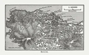
Historic city map of Beirut, Lebanon, wood engraving, published 1897Historic city map of Beirut - capital and largest city of Lebanon. Wood engraving, published in 1897
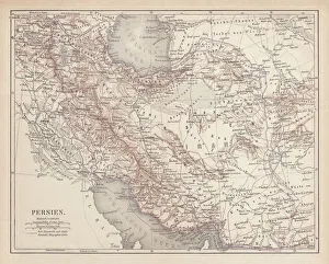
Ancient map of Persia, lithograph, published in 1877Ancient map of Persia. Lithograph, published in 1877
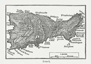
Map of Capri, Italian island, wood engraving published in 1897Map of Capri, Italian island. Wood engraving, published in 1897
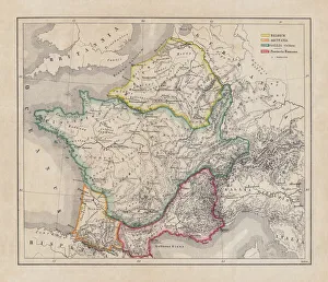
Gaul in the time of Julius Caesar, published in 1867Gaul in the time of Roman politican Gaius Iulius Caesar (100 - 44 BC). Steel engraving with hand-colored borderlines and Latin legend, published in 1867
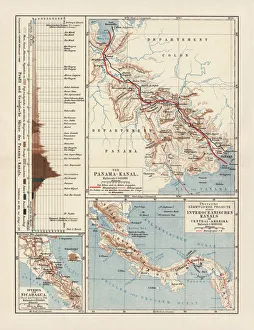
Panama Canal Project, lithograph, published in 1880Ancient map of the Panama Canal Project. Lithograph, published in 1880
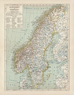
Sweden and Norway, lithograph, published in 1878Ancient map of Sweden and Norway. Lithograph, published in 1878
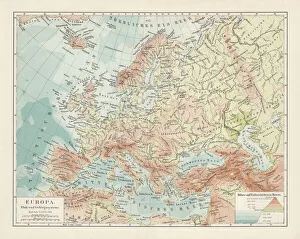
Topographic map of Europe, lithograph, published in 1897Topographic map of Europe. Lithograph, published in 1897
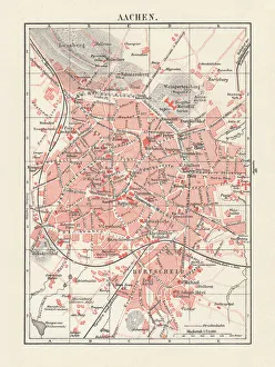
City map of Aachen, Germany, lithograph, published in 1897City map of Aachen, Germany. Lithograph, published in 1897
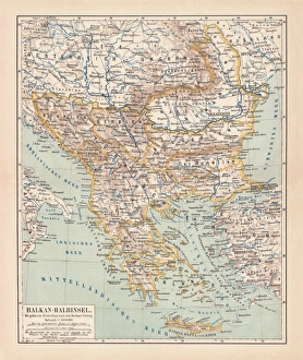
Balkan Peninsula in 1878, lithographAncient map Balkan. The political classification of the Balkan Peninsula after the Treaty of Berlin in 1878. Lithograph, published in 1878
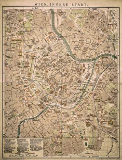
Vienna inner cityAntique map of Vienna from 1898
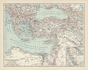
Ottoman Empire, lithograph, published in 1878Ancient map of Ottoman Empire. Lithograph, published in 1878
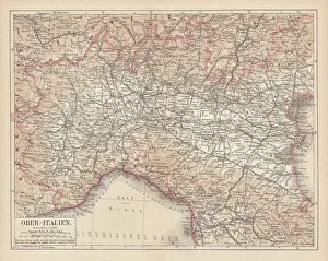
Ancient map of Northern Italy, lithograph, published in 1876Ancient map of Northern Italy. Lithograph, published in 1876
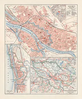
City map of Bremen, Germany, lithograph, published 1897City map of Bremen, Germany. Lithograph, published in 1897
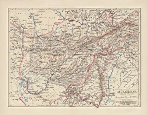
Afghanistan, lithograph, published in 1881Ancient map of Afghanistan. Lithograph, published in 1881
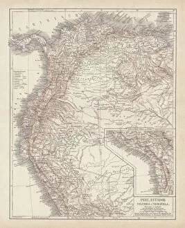
Peru, Ecuador, Colombia, Venezuela, lithograph, published in 1877Ancient map of Peru, Ecuador, Colombia, and Venezuela. Lithograph, published in 1877
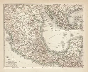
Mexico, ancient map, lithograph, published in 1877Ancient map of Mexico. Lithograph, published in 1877
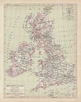
Map of British Isles, lithograph, lithograph, published in 1876Map of British Isles. Lithograph, published in 1876
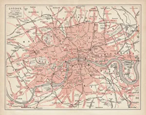
City map of London, lithograph, lithograph, published in 1877City map of London, United Kingdom. Lithograph, published in 1877
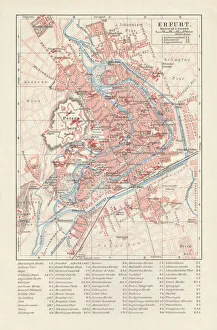
City map of Erfurt, Germany, lithograph, published in 1897City map of Erfurt with street directory, Thuringia, Germany. Lithograph, published in 1897
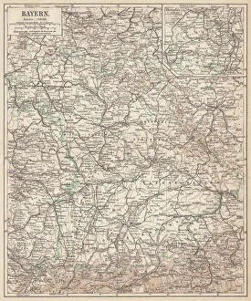
German federal state of Bavaria, lithograph, published in 1874Map of German federal state of Bavaria. Lithograph, published in 1874
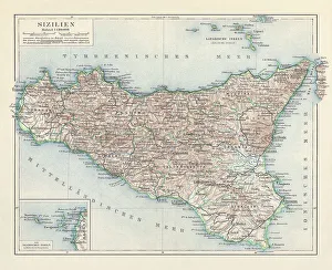
Topographic map of Sicily, Italy, lithograph, published in 1897Topographic map of Sicily, Italy - largest island in the Mediterranean Sea. Lithograph, published in 1897
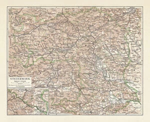
Topographic map of Styria, Austria, lithograph, published in 1897Topographic map of Styria - state (Bundesland) located in the southeast of Austria. Lithograph, published in 1897
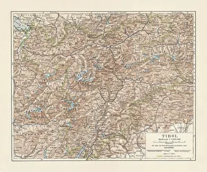
Tyrol, historical region in Austria and Italy, lithograph, published 1897Tyrol - historical region in the Alps; in northern Italy and western Austria. Lithograph, published in 1897
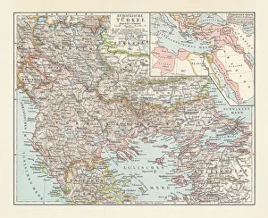
Historical map of the Ottoman Empire (Turkey), European part, 1897Historical map of European part of the Ottoman Empire (Turkey) at the end of the 19th century. Lithograph, published in 1897
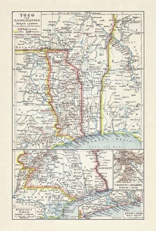
Historical map of Togo during the German colonial period (1884-1916)Historical map of Togo in West Africa during the German colonial period from 1884 to 1916. Lithograph, published in 1897
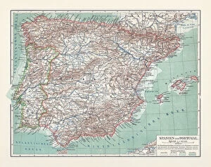
Topographic map of Spain and Portugal, lithograph, published in 1897Topographic map of Spain and Portugal. Lithograph, published in 1897
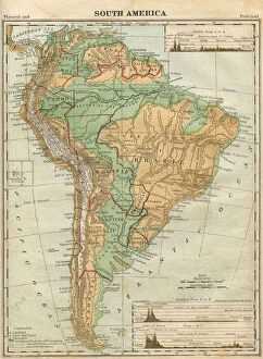
South America Map Illustration, Travel, Exploration, Antique 1871 IllustrationColor stock photo of an antique South America map illustration. Salvaged from an 1871 geography book
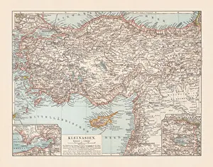
Old topographic map of Asia Minor (Turkey), lithograph, published 1897Old topographic map of Asia Minor (Turkey). Lithograph, published 1897
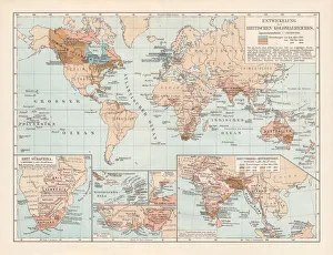
Development of the British Empire, lithograph, published 1897Map of the territorial development of the British Empire from the 17th century to the end of the 19th century. Lithograph, published in 1897
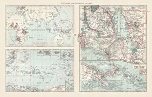
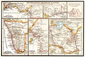
Topographic maps of the former German colonies, lithograph, published 1897Topographic maps of the former German colonies in Africa and the South Seas. Lithograph, published in 1897
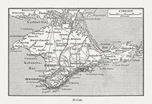
Historical map of Crimea (Ukraine / Russia), wood engraving, published in 1897Historical map of the Peninsula Crimea (Ukraine/Russia). Wood engraving, published in 1897
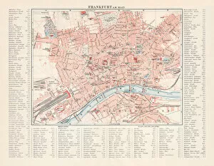
City map of Frankfurt am Main, Hesse, Germany, lithograph, 1897City map of Frankfurt am Main - largest city of the German state of Hesse (with street directory). Lithograph, published in 1897
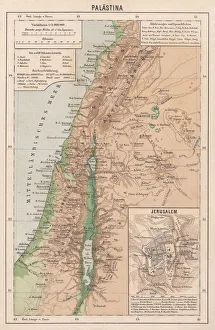
Map of Palestine and Jerusalem, lithograph, published in 1881Detailed topographic map of Palestine and Jerusalem. Facsimile from my archive, published in 1881
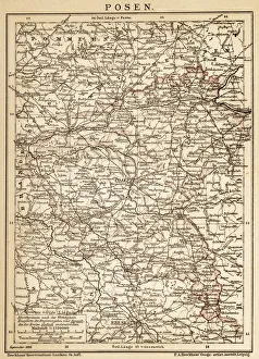
PoznanAncient map of Poznan from 1898
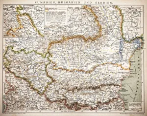
Balkan StatesMap of Rumania, Bulgaria, Serbia, Montenegro
The six principal colonies of German AfricaIllustration of a The six principal colonies of German Africa
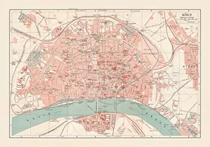
City map of Cologne, North Rhine-Westphalia, Germany, lithograph, published 1897City map of Cologne, North Rhine-Westphalia, Germany. Lithograph, published in 1897
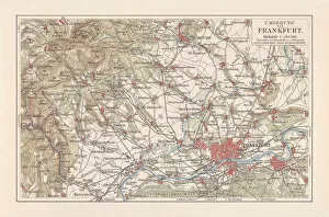
Map of Frankfurt / Main and surroundings, Hesse, Germany, lithograph, published 1897Map of Frankfurt am Main and surroundings in Hesse, Germany. Lithograph, published in 1897
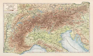
Topographic map of the European Alps, lithograph, published in 1897Topographic map of the European Alps. Lithograph, published in 1897
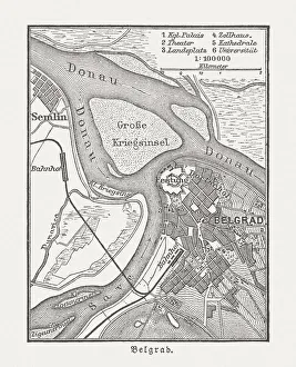
Historic city map of Belgrade, Serbia, wood engraving, published 1897Historic city map of Belgrade - capital and largest city of Serbia. Wood engraving, published in 1897
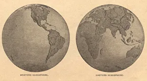
Old, Map of Eastern and Western Hemispheres, From 1875Old black and white illustration of the Eastern Hemisphere and the Western Hemisphere, from the 1800 s
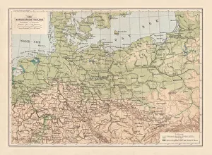
North German lowland map, 19th century view, lithograph, published 1884Old Topographic map of the North German lowland in German language. Lithograph, published in 1884