mail_outline sales@mediastorehouse.com
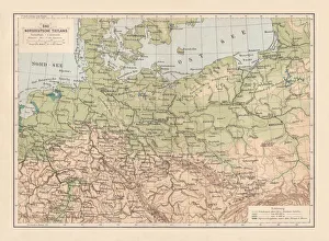
North German lowland map, 19th century view, lithograph, published 1884Old Topographic map of the North German lowland in German language. Lithograph, published in 1884
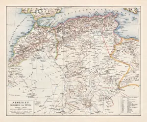
North Africa: Algeria, Morocco and Tunisia, lithograph, published in 1897Topographic map of Algeria, Morocco and Tunisia with the borders at the end of the 19th century. Lithograph, published in 1897
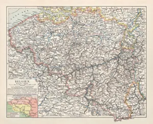
Map of Belgium, lithograph, published in 1897Map of Belgium with the territorial language areas. Lithograph, published in 1897
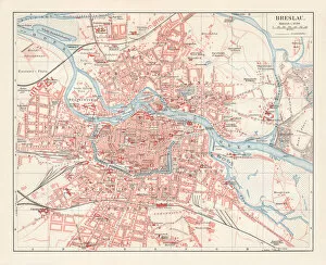
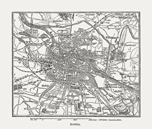
City map of Breslau, (today Wroclaw, Poland), lithograph, published 1897City map of Breslau, Prussia, Germany (today Wroclaw, Poland). Lithograph, published in 1897
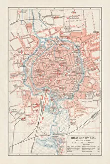
City map of Brunswick, Lower Saxony, Germany, lithograph, published 1897City map of Brunswick in Lower Saxony, Germany. Lithograph, published in 1897
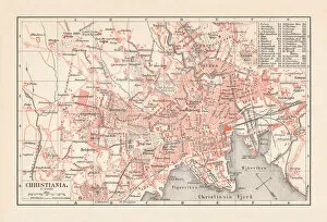
City map of Christiania (now Oslo), Norway, lithograph, published 1897City map of Christiania, now Oslo - capital of Norway. Lithograph, published in 1897
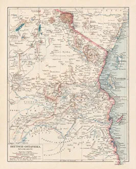
Map of formerly German colony East Africa, lithograph, published 1897Map of the formerly German colony East Africa between 1885 and 1918, (present-day Burundi, Rwanda, and the mainland part of Tanzania). Lithograph, published in 1897
Map of religious affiliation in Germany, lithograph, published in 1897Map of the religious affiliation in Germany at the end of the 19th century. Lithograph, published in 1897
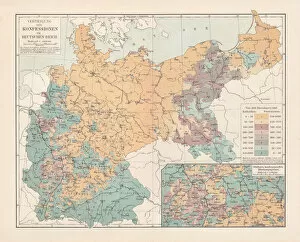
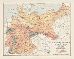
Population density of Germany in 1890, lithograph, published in 1897Map of the population density of Germany in 1890. Lithograph, published in 1897
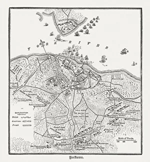
Battle of Yorktown in 1781, wood engraving, published in 1884Plan of the Battle of Yorktown during the American Revolutionary War in 1781. Wood engraving, published in 1884
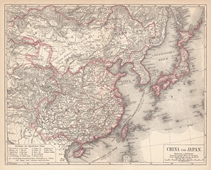
China and Japan, lithograph, published in 1881Antique map of China and Japan. Lithograph, published in 1881
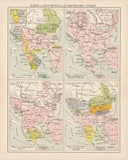
Ottoman Empire, 14th-19th century, lithograph, published in 1878Ancient map of the history of European Turkey, 15th - 19th century. Lithograph, published in 1878
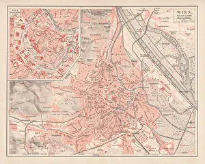
City map of Vienna, Austria, lithograph, published in 1878Ancient map of Vienna, Austria. Lithograph, published in 1878
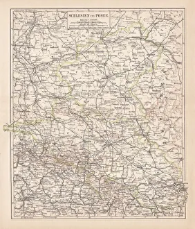
Silesia and Poznan, lithograph, published in 1878Ancient map of Silesia and Poznan, former territories of the German Empire, today Poland. Lithograph, published in 1878
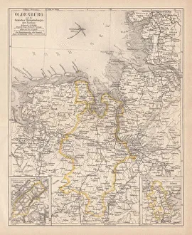
Grand Duchy of Oldenburg, litograph, published in 1877Ancient map of Grand Duchy of Oldenburg, Germany. Lithograph, published in 1877
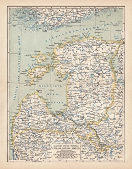
Map of Baltic states, lithograph, published in 1877Historic map of Baltic states: Lithuania, Estonia, Latvia. Lithograph, published in 1877
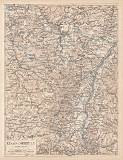
Map of Alsace-Lorraine, lithograph, published in 1875Ancient map of Alsace-Lorraine (German: Elsass-Lothringen). Lithograph, published in 1875
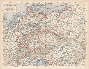
German Empire of 1871-1918, lithograph, published in 1875German Empire within the borders of 1871 - 1918. Lithograph, published in 1875
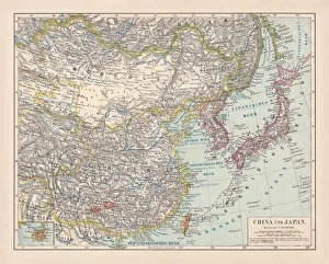
Map of China and Japan, lithograph, published in 1875Map of China and Japan. Lithograph, published in 1875
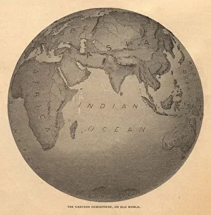
Old, Black and White Illustration of Eastern Hemisphere, From 1800 sOld black and white illustration of the Old World (Eastern Hemisphere), from 1875
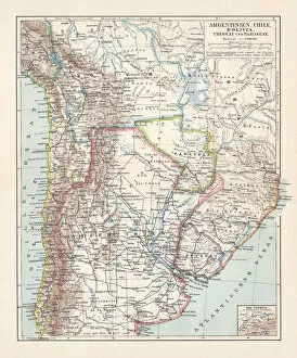
Argentina, Chile, Bolivia, Uruguay, and Paraguay, lithograph, published in 1897Argentina, Chile, Bolivia, Uruguay, and Paraguay. Lithograph, published in 1897
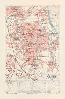
City map of Augsburg, Bavaria, Germany, lithograph, published in 1897
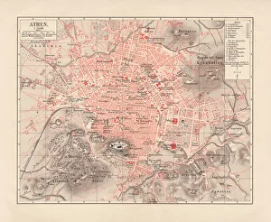
Map of Athens and surroundings, lithograph, published in 1897Map of Athens and surroundings, Greece. Lithograph, published in 1897
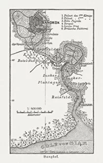
Historic map of Bangkok and surrounding, wood engraving, published 1897Historic map of Bangkok and surrounding, Thailand. Wood engraving, published in 1897
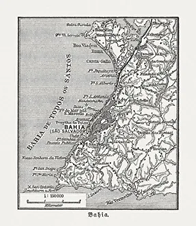
Salvador and surrounding, Bahia, Brazil, wood engraving, published in 1897Map of Salvador and surrounding, Bahia, Brazil. Wood engraving, published in 1897
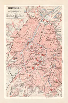
Brussels - capital of Belgium, lithograph, published in 1897Brussels - capital of Belgium. Lithograph, published in 1897
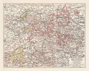
Duchy of Brunswick, Principalities Schaumburg-Lippe, and Waldeck, published 1897Duchy of Brunswick, Principalities Schaumburg-Lippe, and Waldeck in Germany. Lithograph, published in 1897
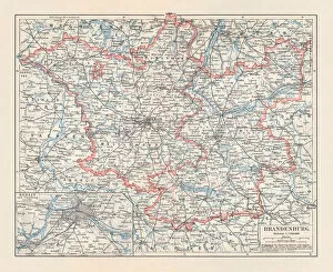
Brandenburg in Germany, mainland, province, and Berlin, lithograph, published 1897The state of Brandenburg in Germany, mainland, province, and Berlin. Lithograph, published in 1897
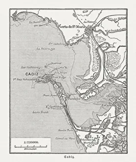
City map of CAadiz, Spain, wood engraving, published in 1897City map of CAadiz, Spain.Wood engraving, published in 1897
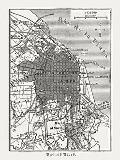
City map of Buenos Aires, Argentina, wood engraving, published 1897City map of Buenos Aires, capital of Argentina. Wood engraving, published in 1897
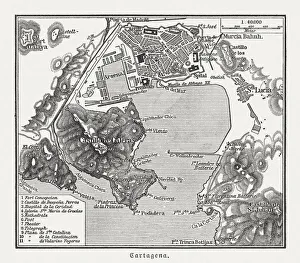
City map of Cartagena, Murcia, Spain, wood engraving, published 1897City map of Cartagena, Murcia, Spain. Wood engraving, published in 1897
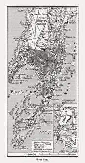
Bombay (Mumbai), India, wood engraving, published in 1897Bombay (Mumbai), India. Wood engraving, published in 1897
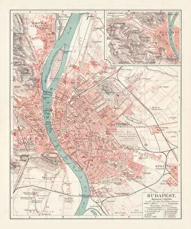
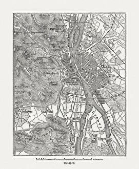
City map of Budapest, capital of Hungary, lithograph, published 1897City map of Budapest - the capital of Hungary. Lithograph, published in 1897
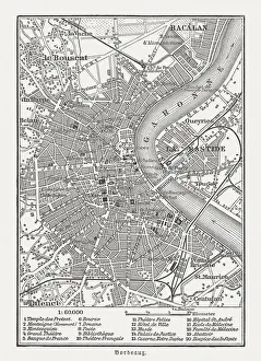
City map of Bordeaux, France, wood engraving, published in 1897City map of Bordeaux, France. Wood engraving, published in 1897
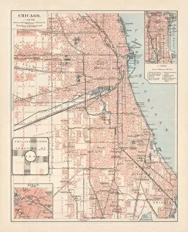
City map of Chicago, Illinois, USA, lithograph, published in 1897City map of Chicago, Illinois, USA. Lithograph, published in 1897
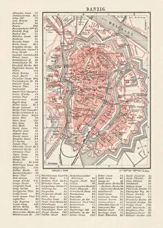
City map of Danzig (now Gdsk, Poland), lithograph, published 1897City map of Danzig with street directory, Prussia, Germany (now Gdsk, Poland). Lithograph, published in 1897
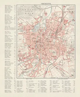
City map of Chemnitz, Germany, lithograph, published in 1897City map of Chemnitz with street directory, Saxony, Germany. Lithograph, published in 1897
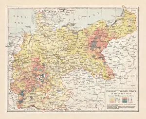
Distribution of the Jews in Germany, lithograph, published in 1897Map of the distribution of the Jews in Germany at the end of the 19th century. Lithograph, published in 1897
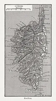
Map of the island Corsica, France, wood engraving, published in 1897Map of the island Corsica, France. Wood engraving, published in 1897
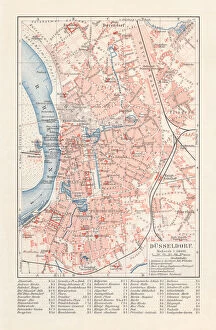
City map of DAOEsseldorf, Germany, lithograph, published in 1897City map of DAOEsseldorf - capital city of the German state of North Rhine-Westphalia (with street directory). Lithograph, published in 1897
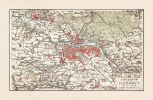
Map of Dresden and surroundings, Saxony, Germany, lithograph, published 1897Map of Dresden and surroundings - capital city of the German state Saxony. Lithograph, published in 1897
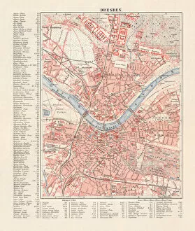
City map of Dresden, Saxony, Germany, lithograph, published in 1897City map of Dresden - capital city of the German state of Saxony (with street directory). Lithograph, published in 1897
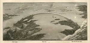
Topographical Land Sea Sky Earth Globe, Antique 1871 IllustrationColor stock photo of an antique illustration of a topographical earth globe showing land, sea and sky examples. Salvaged from an 1871 geography book
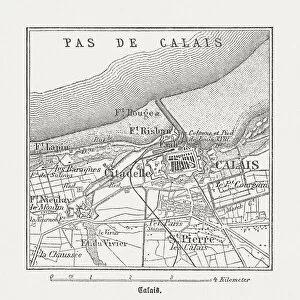
Calais, France, wood engraving, published in 1882City map of Calais, France. Wood engraving, published in 1882
Budapest, wood engraving, published in 1882City map Budapest, capital of Hungary. Wood engraving, published in 1882
Breslau (Wrocaw, Poland), wood engraving, published in 1882Breslau (formerly German Empire), today Wrocaw, Poland. Wood engraving, published in 1882
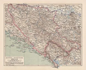
Bosnia and Montenegro, lithograph, published in 1881Ancient map of Bosnia and Montenegro. Lithograph, published in 1881
City map of Athens, lithograph, published in 1881City map of Athens. Lithograph, published in 1881