mail_outline sales@mediastorehouse.com
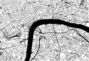
City of London Road MapBlack and white illustration of geographical, road map of London, UK
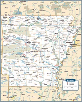
Arkansas State MapArkansas is a southern US state bordering the Mississippi River
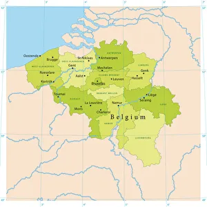
Belgium Vector MapHighly detailed vector map of Belgium. File was created on July 14, 2011. The colors in the.eps-file are ready for print (CMYK). Included files: EPS (v8) and Hi-Res JPG
Hello Speech Bubble QuotationHello on white quote bubble with quote symbols
Tree full of hearts illustrationArt Illustrations, Digital Vision Vectors, 505221388
Monstera Leaf IllustrationWatercolor Monstera Leaf. In eastern culture, monstera plants symbolize longevity, respect, and honor. In western cultures
Woman with RootsThe Magical World of Illustration, 832769334
Mens Basketball SequenceVector illustration of a basketball player taking a shot
Christmas Tree IllustrationHand-drawn cartoon cute illustration of Christmas tree
Covid Safe Santa ClausIllustration of Christmas Santa Claus with Covid 19 safety mask giving a gift to a child
Violet goldfish standing out from the crowdA violet goldfish standing out the crowd. Hand-drawn illustration directly with a tablet
What? Standing out from the crowdIllustration of a pop art style uniform shoal of reef fish plus one rebel on a multi-coloured background created using flat colours
Watercolor Monarch ButterflyA vector illustration of a butterfly in watercolor paint
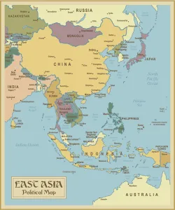
Vintage Map of East Asia
Simple, modern depiction of a celestial constellation - VirgoSimple, modern depiction of a celestial constellation on a navy backdrop. Virgo is the largest constellation of the Zodiac and the second-largest constellation overall, behind Hydra
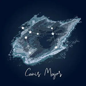
Modern Night Sky Constellation - Canis MajorSimple, modern depiction of a celestial constellation. The constellation Canis Major is located in the southern hemisphere of the sky
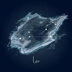
Modern Night Sky Constellation - LeoSimple, modern depiction of a celestial constellation on a navy backdrop. Leo constellation lies in the northern sky and is one of the zodiac constellations
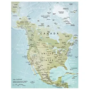
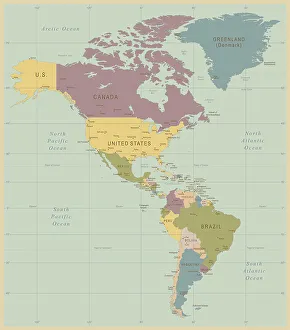
North America mapVector illustration of a detailed map of North America. Reference map was created by the US Central Intelligence Agency and is available as a public domain map at the University of Texas Libraries
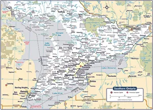
Southern Ontario Provinical apReference Maps, 103745704
Shivering BirdsFour birds with wooly hats and scarfs sitting on a branch. It's cold and snowing and one of them even has small icicles on its frozen blue foot
Vintage Map of North and South America534055040
Rottweiler Head IllustrationThe Rottweiler breeds predominant feature is the shape and size of the head
T-Rex Skull IllustrationThe Tyrannosaurus rex was one of the largest and most fearsome carnivores of all time
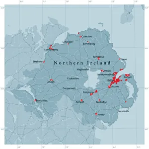
Northern Ireland Vector Road MapDetailed vector map of Northern Ireland, including main cities, roads, rivers and lakes. Source data courtesy of the former United States National Imagery and Mapping Agency NIMA (database: VMAP0)
Don Quixote - Hero on Old HorseDon Quixote. Pen and ink style illustration of Don Quixote on the old nag, Rocinante
astrology_finalZodiac and astrological icons and symbols collection
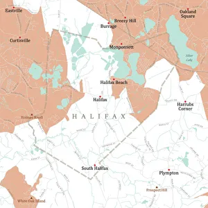
MA Plymouth Halifax Vector Road Map. All source data is in the public domain. U.S. Census Bureau Census Tiger. Used Layers: areawater, linearwater, roads, rails, cousub, pointlm, uac10
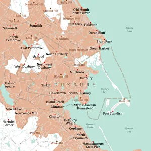
MA Plymouth Duxbury Vector Road Map. All source data is in the public domain. U.S. Census Bureau Census Tiger. Used Layers: areawater, linearwater, roads, rails, cousub, pointlm, uac10
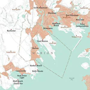
MA Plymouth Marion Vector Road Map. All source data is in the public domain. U.S. Census Bureau Census Tiger. Used Layers: areawater, linearwater, roads, rails, cousub, pointlm, uac10
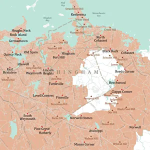
MA Plymouth Hingham Vector Road Map. All source data is in the public domain. U.S. Census Bureau Census Tiger. Used Layers: areawater, linearwater, roads, rails, cousub, pointlm, uac10
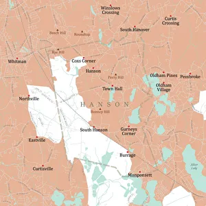
MA Plymouth Hanson Vector Road Map. All source data is in the public domain. U.S. Census Bureau Census Tiger. Used Layers: areawater, linearwater, roads, rails, cousub, pointlm, uac10
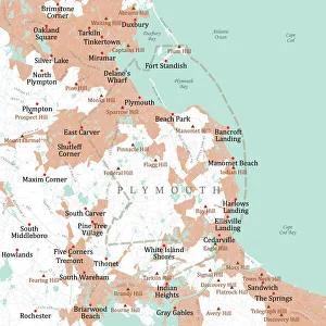
MA Plymouth Vector Road Map. All source data is in the public domain. U.S. Census Bureau Census Tiger. Used Layers: areawater, linearwater, roads, rails, cousub, pointlm, uac10
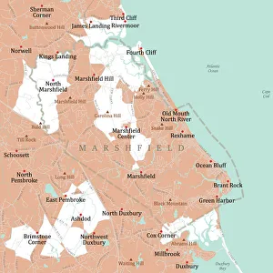
MA Plymouth Marshfield Vector Road Map. All source data is in the public domain. U.S. Census Bureau Census Tiger. Used Layers: areawater, linearwater, roads, rails, cousub, pointlm, uac10
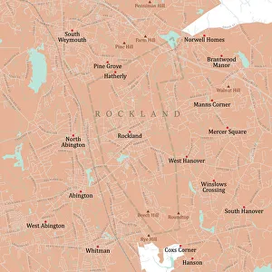
MA Plymouth Rockland Vector Road Map. All source data is in the public domain. U.S. Census Bureau Census Tiger. Used Layers: areawater, linearwater, roads, rails, cousub, pointlm, uac10
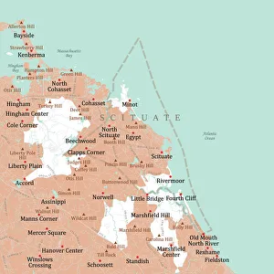
MA Plymouth Scituate Vector Road Map. All source data is in the public domain. U.S. Census Bureau Census Tiger. Used Layers: areawater, linearwater, roads, rails, cousub, pointlm, uac10
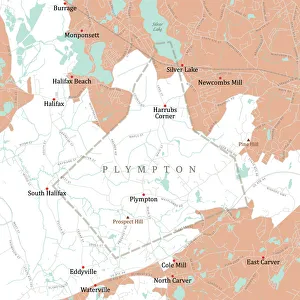
MA Plymouth Plympton Vector Road Map. All source data is in the public domain. U.S. Census Bureau Census Tiger. Used Layers: areawater, linearwater, roads, rails, cousub, pointlm, uac10
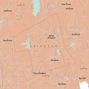
MA Plymouth Abington Vector Road Map. All source data is in the public domain. U.S. Census Bureau Census Tiger. Used Layers: areawater, linearwater, roads, rails, cousub, pointlm, uac10
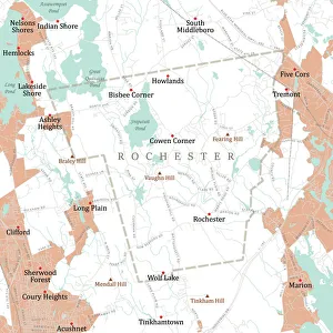
MA Plymouth Rochester Vector Road Map. All source data is in the public domain. U.S. Census Bureau Census Tiger. Used Layers: areawater, linearwater, roads, rails, cousub, pointlm, uac10
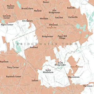
MA Plymouth Bridgewater Town Vector Road Map. All source data is in the public domain. U.S. Census Bureau Census Tiger. Used Layers: areawater, linearwater, roads, rails, cousub, pointlm, uac10
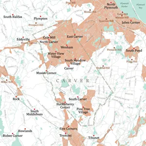
MA Plymouth Carver Vector Road Map. All source data is in the public domain. U.S. Census Bureau Census Tiger. Used Layers: areawater, linearwater, roads, rails, cousub, pointlm, uac10
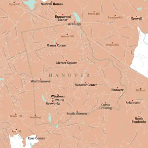
MA Plymouth Hanover Vector Road Map. All source data is in the public domain. U.S. Census Bureau Census Tiger. Used Layers: areawater, linearwater, roads, rails, cousub, pointlm, uac10
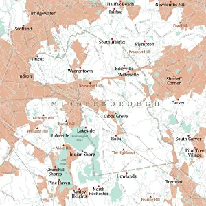
MA Plymouth Middleborough Vector Road Map. All source data is in the public domain. U.S. Census Bureau Census Tiger. Used Layers: areawater, linearwater, roads, rails, cousub, pointlm, uac10
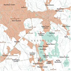
MA Plymouth Lakeville Vector Road Map. All source data is in the public domain. U.S. Census Bureau Census Tiger. Used Layers: areawater, linearwater, roads, rails, cousub, pointlm, uac10
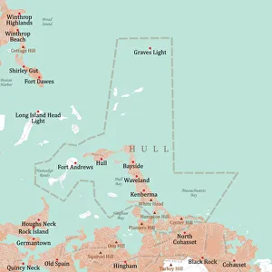
MA Plymouth Hull Vector Road Map. All source data is in the public domain. U.S. Census Bureau Census Tiger. Used Layers: areawater, linearwater, roads, rails, cousub, pointlm, uac10
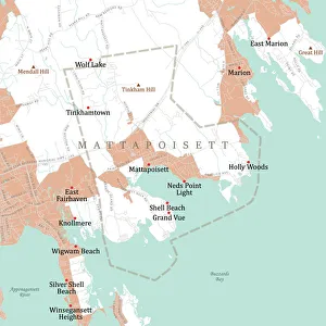
MA Plymouth Mattapoisett Vector Road Map. All source data is in the public domain. U.S. Census Bureau Census Tiger. Used Layers: areawater, linearwater, roads, rails, cousub, pointlm, uac10
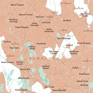
MA Plymouth Pembroke Vector Road Map. All source data is in the public domain. U.S. Census Bureau Census Tiger. Used Layers: areawater, linearwater, roads, rails, cousub, pointlm, uac10
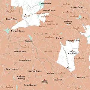
MA Plymouth Norwell Vector Road Map. All source data is in the public domain. U.S. Census Bureau Census Tiger. Used Layers: areawater, linearwater, roads, rails, cousub, pointlm, uac10
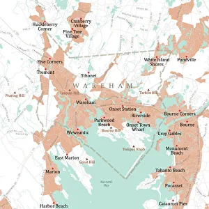
MA Plymouth Wareham Vector Road Map. All source data is in the public domain. U.S. Census Bureau Census Tiger. Used Layers: areawater, linearwater, roads, rails, cousub, pointlm, uac10