Home > Map > Denmark Maps
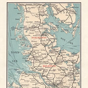
Topographic map of Schleswig-Holstein, German Empire, lithograph, published in 1897

![]()
Wall Art and Photo Gifts from Fine Art Storehouse
Topographic map of Schleswig-Holstein, German Empire, lithograph, published in 1897
Topographic map of Schleswig-Holstein in the German Reich with the former border to Denmark after the German-Danish War (Second Schleswig War) in 1864, existing until 1920. Separate maps of the Kiel Bay and the island of Helgoland. Lithograph, published in 1897
ZU_09
Media ID 18356521
FEATURES IN THESE COLLECTIONS
> Map
> Denmark Maps
> Map
> Historical Maps
> Map
MADE IN THE UK
Safe Shipping with 30 Day Money Back Guarantee
FREE PERSONALISATION*
We are proud to offer a range of customisation features including Personalised Captions, Color Filters and Picture Zoom Tools
SECURE PAYMENTS
We happily accept a wide range of payment options so you can pay for the things you need in the way that is most convenient for you
* Options may vary by product and licensing agreement. Zoomed Pictures can be adjusted in the Basket.