mail_outline sales@mediastorehouse.com
149 Items
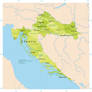
Croatia Vector MapHighly detailed vector map of Croatia. File was created on September 14, 2011. The colors in the.eps-file are ready for print (CMYK). Included files: EPS (v8) and Hi-Res JPG
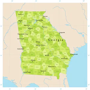
Georgia State Vector MapHighly detailed vector map of Georgia, United States. File was created on April 17, 2012. The colors in the.eps-file are ready for print (CMYK). Included files: EPS (v8) and Hi-Res JPG
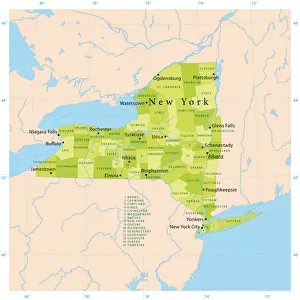
New York State Vector MapHighly detailed vector map of New York State, United States. File was created on January 24, 2012. The colors in the.eps-file are ready for print (CMYK). Included files: EPS (v8) and Hi-Res JPG
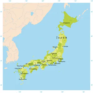
Japan Vector MapHighly detailed vector map of Japan. File was created on August 23, 2012. The colors in the.eps-file are ready for print (CMYK). Included files: EPS (v8) and Hi-Res JPG (5600 x 5600 px)
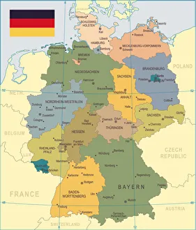
Germany Map - illustrationColored Map of the Germany
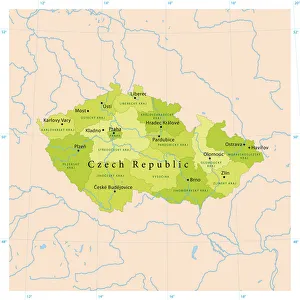
Czech Republic Vector MapHighly detailed vector map of the Czech Republic. File was created on September 9, 2011. The colors in the.eps-file are ready for print (CMYK). Included files: EPS (v8) and Hi-Res JPG
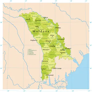
Moldova Vector MapHighly detailed vector map of Moldova. File was created on October 18, 2011. The colors in the.eps-file are ready for print (CMYK). Included files: EPS (v8) and Hi-Res JPG
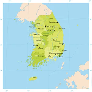
South Korea Vector MapHighly detailed vector map of South Korea. File was created on August 29, 2012. The colors in the.eps-file are ready for print (CMYK). Included files: EPS (v8) and Hi-Res JPG (5600 x 5600 px)
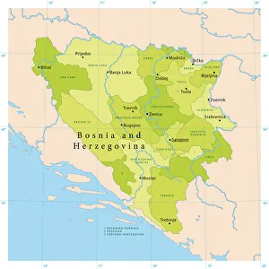
Bosnia Herzegovina Vector MapHighly detailed vector map of Bosnia and Herzegovina. File was created on October 11, 2011. The colors in the.eps-file are ready for print (CMYK). Included files: EPS (v8) and Hi-Res JPG
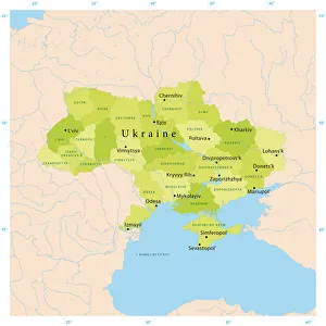
Ukraine Vector MapHighly detailed vector map of Ukraine. File was created on December 16, 2011. The colors in the.eps-file are ready for print (CMYK). Included files: EPS (v8) and Hi-Res JPG
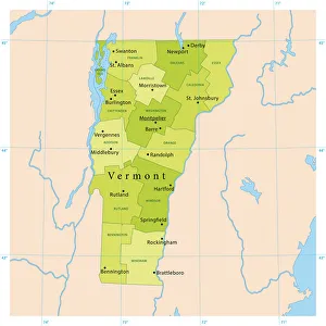
Vermont Vector MapHighly detailed vector map of Vermont, United States. Source data courtesy of NGDC (database: World Data Bank II), NASA (reference images: Blue Marble) and National Atlas (database)
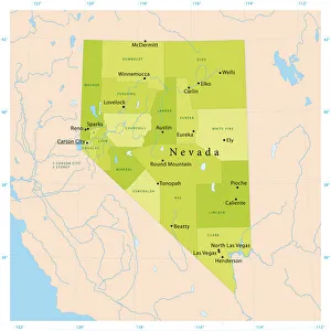
Nevada Vector MapHighly detailed vector map of Nevada, United States. File was created on January 27, 2012. The colors in the.eps-file are ready for print (CMYK). Included files: EPS (v8) and Hi-Res JPG
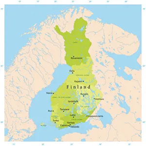
Finland Vector MapHighly detailed vector map of Finland. File was created on November 24, 2011. The colors in the.eps-file are ready for print (CMYK). Included files: EPS (v8) and Hi-Res JPG
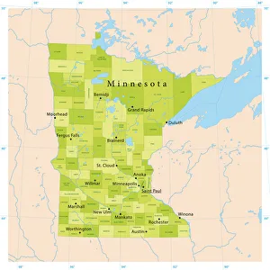
Minnesota Vector MapHighly detailed vector map of Minnesota, United States. File was created on December 19, 2012. The colors in the.eps-file are ready for print (CMYK)
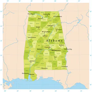
Alabama Vector MapHighly detailed vector map of Alabama, United States. File was created on April 10, 2012. The colors in the.eps-file are ready for print (CMYK). Included files: EPS (v8) and Hi-Res JPG
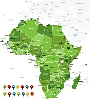
Africa MapAfrica Green High detailed map with navigation icons
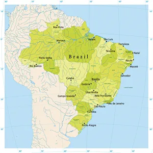
Brazil Vector MapUltra detailed vector map of Brazil with administrative divisions. Including main rivers and lakes. Each state is grouped separately. You can zoom in well in the vector file
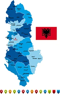
Albania Vector MapHigh Detailed Albania Blue Map with Navigation Icons
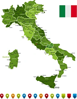
Italy MapHigh Detailed Italy Green Map with Navigation Icons
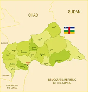
Flat map of Central African Republic with flagDetailed map of Central African Republic with surroundings, provinces, capital and flag. The url of the reference to political map is: Layers of data used: text, flag, map
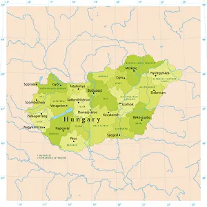
Hungary Vector MapHighly detailed vector map of Hungary. File was created on September 6, 2011. The colors in the.eps-file are ready for print (CMYK). Included files: EPS (v8) and Hi-Res JPG
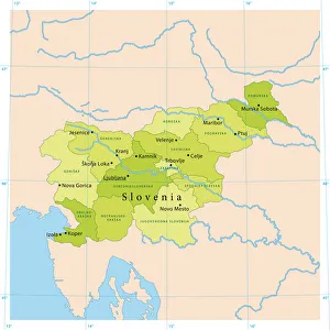
Slovenia Vector MapHighly detailed vector map of Slovenia. File was created on September 23, 2011. The colors in the.eps-file are ready for print (CMYK). Included files: EPS (v8) and Hi-Res JPG
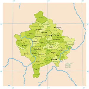
Kosovo Vector MapHighly detailed vector map of Kosovo. File was created on November 2, 2011. The colors in the.eps-file are ready for print (CMYK). Included files: EPS (v8) and Hi-Res JPG
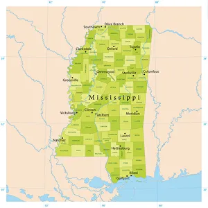
Mississippi Vector MapHighly detailed vector map of Mississippi, United States. Source data courtesy of NGDC (database: World Data Bank II), NASA (reference images: Blue Marble) and National Atlas (database)
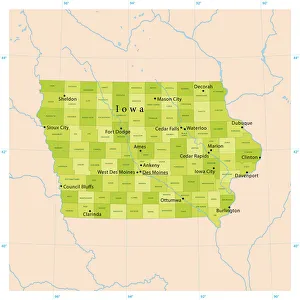
Iowa Vector MapHighly detailed vector map of Iowa, United States. File was created on January 16, 2013. The colors in the.eps-file are ready for print (CMYK)
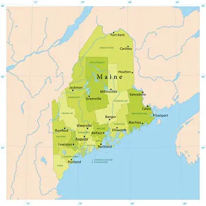
Maine Vector MapHighly detailed vector map of Maine, United States. File was created on January 27, 2012. The colors in the.eps-file are ready for print (CMYK). Included files: EPS (v8) and Hi-Res JPG
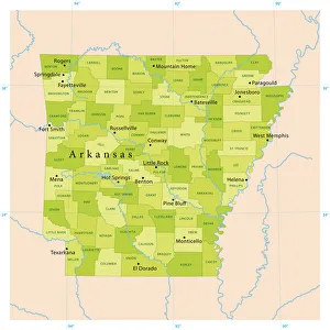
Arkansas Vector MapHighly detailed vector map of Arkansas, United States. File was created on April 12, 2012. The colors in the.eps-file are ready for print (CMYK). Included files: EPS (v8) and Hi-Res JPG
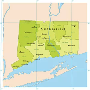
Connecticut Vector MapDetailed vector map of Connecticut, United States. File was created on November 7, 2012. The colors in the.eps-file are ready for print (CMYK)
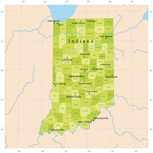
Indiana Vector MapHighly detailed vector map of Indiana, United States. File was created on January 16, 2013. The colors in the.eps-file are ready for print (CMYK)
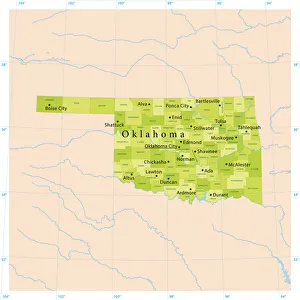
Oklahoma Vector MapHighly detailed vector map of Oklahoma, United States. File was created on January 15, 2013. The colors in the.eps-file are ready for print (CMYK)
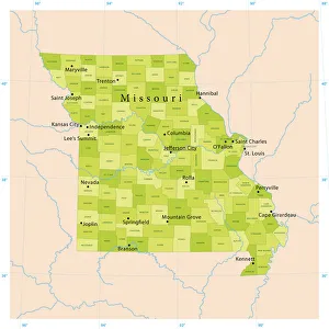
Missouri Vector MapHighly detailed vector map of Missouri, United States. File was created on April 19, 2012. The colors in the.eps-file are ready for print (CMYK). Included files: EPS (v8) and Hi-Res JPG
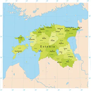
Estonia Vector MapHighly detailed vector map of Estonia. File was created on August 21, 2012. The colors in the.eps-file are ready for print (CMYK). Included files: EPS (v8) and Hi-Res JPG (2800 x 2800 px)
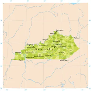
Kentucky Vector MapHighly detailed vector map of Kentucky, United States. Source data courtesy of NGDC (database: World Data Bank II), NASA (reference images: Blue Marble) and National Atlas (database)
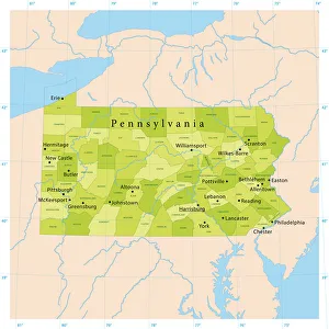
Pennsylvania Vector MapHighly detailed vector map of Pennsylvania, United States. File was created on November 26, 2012. The colors in the.eps-file are ready for print (CMYK)
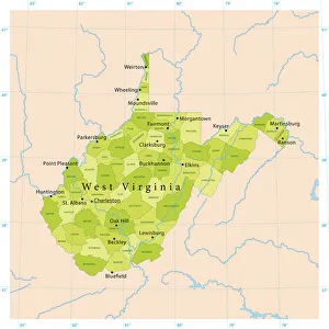
West Virginia Vector MapHighly detailed vector map of West Virginia, United States. Source data courtesy of NGDC (database: World Data Bank II), NASA (reference images: Blue Marble) and National Atlas (database)
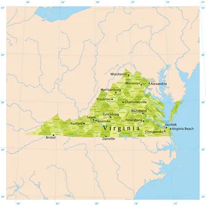
Virginia Vector MapHighly detailed vector map of Virginia, United States. Source data courtesy of NGDC (database: World Data Bank II), NASA (reference images: Blue Marble) and National Atlas (database)
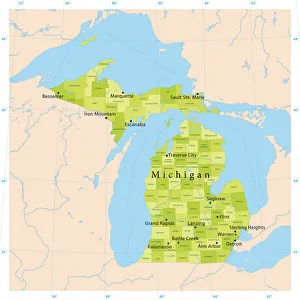
Michigan Vector MapHighly detailed vector map of Michigan, United States. File was created on November 14, 2012. The colors in the.eps-file are ready for print (CMYK)
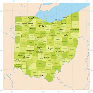
Ohio Vector MapHighly detailed vector map of Ohio, United States. File was created on November 16, 2012. The colors in the.eps-file are ready for print (CMYK)
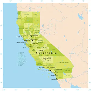
California Vector MapHighly detailed vector map of California, United States. File was created on January 18, 2012. The colors in the.eps-file are ready for print (CMYK). Included files: EPS (v8) and Hi-Res JPG
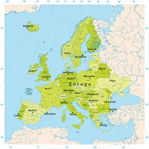
Europe Vector MapUltra detailed vector map of Europe. Including main rivers and lakes. Each country is grouped separately. You can zoom in well in the vector file
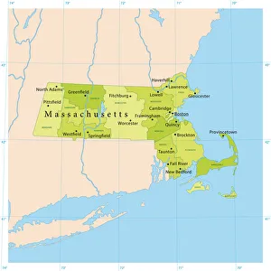
Massachusetts Vector MapHighly detailed vector map of Massachusetts, United States. File was created on October 31, 2012. The colors in the.eps-file are ready for print (CMYK)
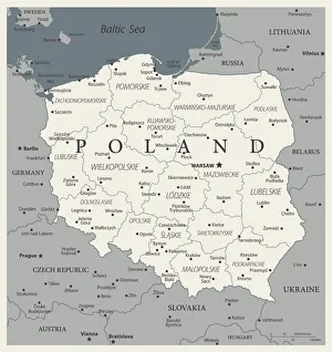
24 - Poland - Vintage Murena Isolated 10Map of Poland - Vintage Vector illustration
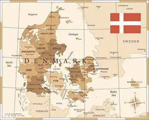
25 - Denmark - Vintage Golden 10Map of Denmark - Vintage Vector illustration
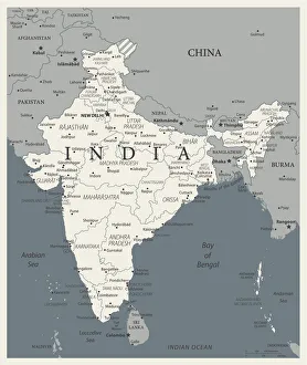
24 - India - Vintage Murena Isolated 10Map of India - Vintage Vector illustration
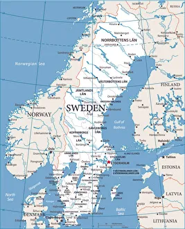
Map of Sweden - Vector illustration
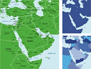
Middle east maphighly detailed map of Middle East with Individual Countries and Continents for your design, products and print
Map of Middle East and Navigation IconsBlue Map of Middle East Asia and Navigation Icons
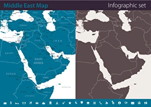
Map of Middle East - Infographic SetVector maps of Middle East Asia with variable specification and icons