Home > Map > Historical Maps
Napoleonic Europe

![]()
Wall Art and Photo Gifts from Fine Art Storehouse
Napoleonic Europe
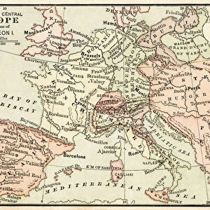
A map of Europe at the end of the Napoleonic Wars, 1815. The boundary of the German Confederation is marked in red, and boundary of Prussia in blue. (Photo by Hulton Archive/Getty Images)
Hulton Archive
Media ID 13609129
© 2011 Getty Images
1810 1819 Huty 16810 Napoleonic Wars
FEATURES IN THESE COLLECTIONS
> Map
> Historical Maps
> Map
MADE IN THE UK
Safe Shipping with 30 Day Money Back Guarantee
FREE PERSONALISATION*
We are proud to offer a range of customisation features including Personalised Captions, Color Filters and Picture Zoom Tools
SECURE PAYMENTS
We happily accept a wide range of payment options so you can pay for the things you need in the way that is most convenient for you
* Options may vary by product and licensing agreement. Zoomed Pictures can be adjusted in the Basket.