Home > Map
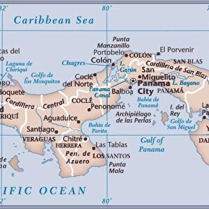
Map, Plan of the Panama Canal, 19th Century

![]()
Wall Art and Photo Gifts from Fine Art Storehouse
Map, Plan of the Panama Canal, 19th Century
Vintage engraving of a Map, Plan of the Panama Canal, 19th Century. An artificial 82 km (51 mi) waterway in Panama that connects the Atlantic Ocean with the Pacific Ocean. The canal cuts across the Isthmus of Panama and is a conduit for maritime trade
duncan1890
Media ID 19746095
© of Duncan P Walker
FEATURES IN THESE COLLECTIONS
> Map
> Historical Maps
> Map
MADE IN THE UK
Safe Shipping with 30 Day Money Back Guarantee
FREE PERSONALISATION*
We are proud to offer a range of customisation features including Personalised Captions, Color Filters and Picture Zoom Tools
SECURE PAYMENTS
We happily accept a wide range of payment options so you can pay for the things you need in the way that is most convenient for you
* Options may vary by product and licensing agreement. Zoomed Pictures can be adjusted in the Basket.