mail_outline sales@mediastorehouse.com
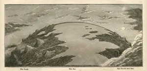
Topographical Land Sea Sky Earth Globe, Antique 1871 IllustrationColor stock photo of an antique illustration of a topographical earth globe showing land, sea and sky examples. Salvaged from an 1871 geography book
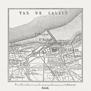
Calais, France, wood engraving, published in 1882City map of Calais, France. Wood engraving, published in 1882
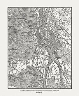
Budapest, wood engraving, published in 1882City map Budapest, capital of Hungary. Wood engraving, published in 1882
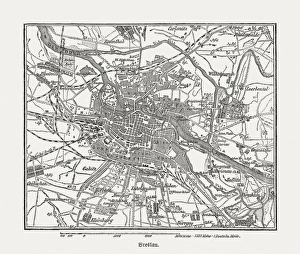
Breslau (Wrocaw, Poland), wood engraving, published in 1882Breslau (formerly German Empire), today Wrocaw, Poland. Wood engraving, published in 1882
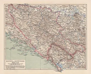
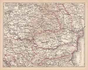
Bosnia and Montenegro, lithograph, published in 1881Ancient map of Bosnia and Montenegro. Lithograph, published in 1881
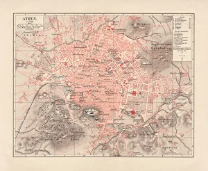
City map of Athens, lithograph, published in 1881City map of Athens. Lithograph, published in 1881
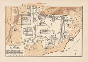
Excavations of Olympia, lithograph, published in 1880Old map of the plan of the excavations of Olympia. Lithograph, published in 1880
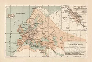
Pestilence in Europe, mid-14th century, lithograph, published in 1880Ancient map of the area of pestilence in Europe, Western Asia, and North Africa in the years 1346 - 1351. Lithograph, published in 1880
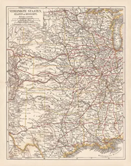
United States of America, States on Mississippi river, lithograph published 1878United States of America, States on the Mississippi river. Lithograph, published in 1878
United States of America, Atlantic coast, lithograph, published in 1878United States of America, Atlantic coast. Lithograph, published in 1878
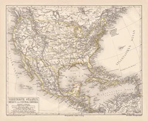
United States of America, Mexico and Central America, published in 1878United States of America, Mexico and Central America. Lithograph, published in 1878
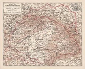
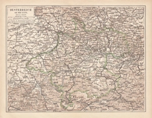
Hungary, lithograph, published in 1878Ancient map of Hungarian Monarchy, Galicia and Bukovina. Lithograph, published in 1878
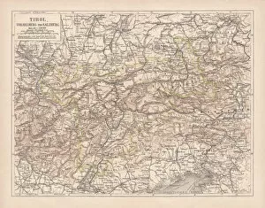
Tirol, Vorarlberg and Salzburg in Austria, lithograph, published in 1878Ancient map of Tirol, Vorarlberg and Salzburg in Austria. Lithograph, published in 1878
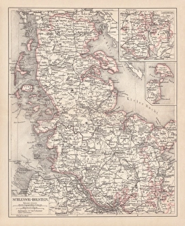
Schleswig-Holstein, lithograph, published in 1878Map of Schleswig-Holstein. Lithograph, published in 1878
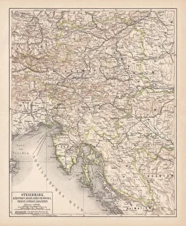
Styria, lithograph, published in 1878Ancient map of Styria: Carinthia, Carniola, GradiAaka, Croatia, Istria, Triest. Lithograph, published in 1878
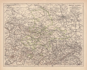
Province of Saxony, lithograph, published in 1878Province of Saxony, former territory of Prussia from 1816 to 1945. Lithograph, published in 1878
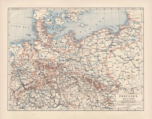
Prussia, lithograph, lithograph, published in 1878The Kingdom of Prussia at its greatest extent, after 1866. Lithograph, published in 1878
Balkan States, lithograph, published in 1878Ancient map of the Balkan States: Romania, Bulgaria, Serbia and Montenegro. Lithograph, published in 1878
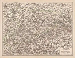
Kingdom of Saxony, lithograph, published in 1878Kingdom of Saxony. Lithograph, published in 1878
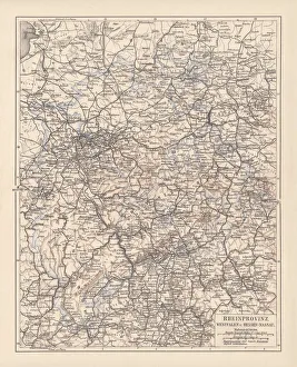
Prussian provinces, lithograph, published in 1878Prussian provinces: Rhineland, Westphalia, and Hesse-Nassau. Lithograph, published in 1878
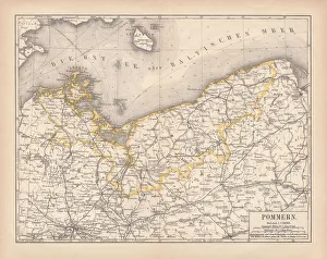
Pomerania, lithograph, lithograph, published in 1878Pomerania, former territory of the German Empire. Lithograph, published in 1878
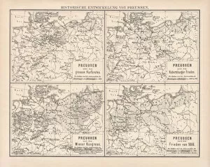
Historical development of Prussia, lithograph, published in 1878Ancient maps of the historical development of Prussia, 17th - 19th century. Lithograph, published in 1878
Upper Austria, lithograph, published in 1877Upper Austria (Austria above the Enns, A-sterreich ob der Enns). Lithograph, published in 1877
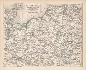
Ancient map of Mecklenburg, lithograph, published in 1877Ancient map of Mecklenburg, Germany. Lithograph, published in 1877
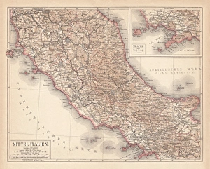
Map of Central Italy, lithograph, puplished in 1876Map of Central Italy. Lithograph, published in 1876
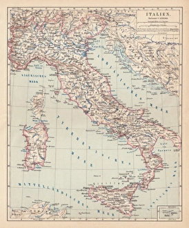
Map of Italy, lithograph, published in 1876Map of Italy. Lithograph, published in 1876
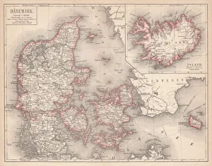
Map of Denmark and Iceland, lithograph, published in 1875Map of Denmark and Iceland. Lithograph, published in 1875
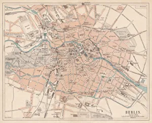
Berlin, city map, lithograph, published in 1874Historic city map of Berlin, Germany. Lithograph, published in 1874
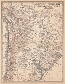
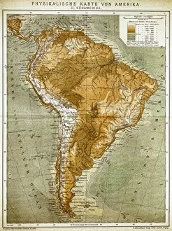
Argentina, Bolivia, Chile, Paraguay and Uruguay, lithograph, published in 1874South American countries: Argentina, Bolivia, Chile, Paraguay and Uruguay. Lithograph, published in 1874
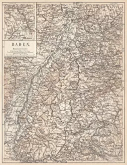
Historical German territory of Baden, lithograph, published in 1874Map of Baden - a historical German territory (today Baden-Wurttemberg). Lithograph, published in 1874
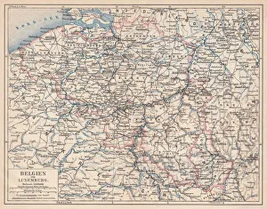
Belgium and Luxembourg, lithograph, published in 1874Antique map of Belgium and Luxembourg. Lithograph, published in 1874
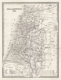
Map of Palestine, steel engraving, published in 1836Topographic Map of Palestine, 1832. Steel engraving by J. Zipter, published in 1836
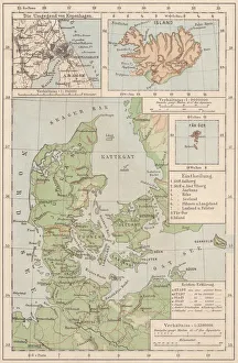
Map of Denmark and Iceland, lithograph, published in 1881Topographic map of Denmark and Iceland. Facsimile, published in 1881
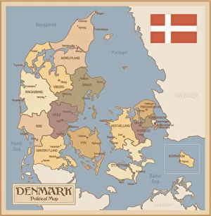
Vintage Map of DenmarkDenmark - Retro Map
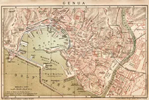
Map of Genoa 1898
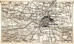
KonigsbergAntique map of Konigsberg
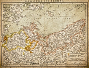
Mecklenburg and PomeraniaAncient map of Mecklenburg and Pomerania
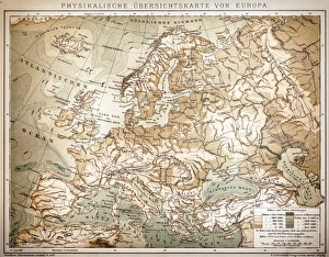
Physical outline map of EuropeAntique illustration of Physical outline map of Europe
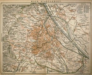
Vienna, city landscape 1898Antique illustration of Vienna, city landscape
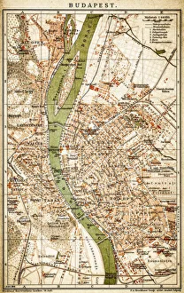
Budapest, capital of Hungary from 1898
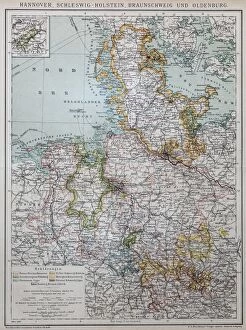
Hannover, Schleswig-Holstein, Braunschweig and Oldenburg
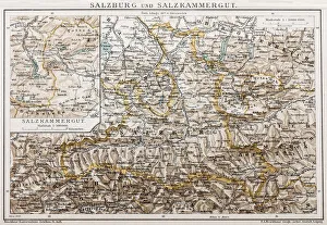
Salzburg and Lake DistrictAntique illustration of a Salzburg and Lake District
The Duke of RichelieuAntique illustration of The Duke of Richelieu by Jean-Baptiste Pigalle
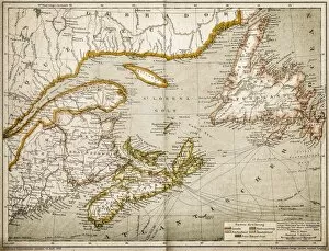
Eastern Canada and NewfoundlandIllustration of a Eastern Canada and Newfoundland
Euphorbia officinarumillustration of a Euphorbia officinarum
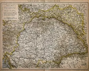
Hungary and GaliciaAntique Illustration map of a Hungary and Galicia
United States of America mapAntique illustration of a United States of America map
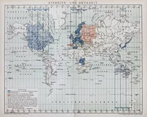
Local time world mapAntique illustration of a local time world map