mail_outline sales@mediastorehouse.com
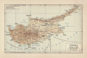
Map of Cyprus, published in 1880Ancient map of Cyprus. Lithograph, published in 1880
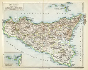
Sicily map 1895Meyers Konversations-Lexikon. Ein Nachschlagewerk des allgemeinen Wissens, 5th edition 17 volumes Bibliographisches Institut - Leipzig 1895-1897
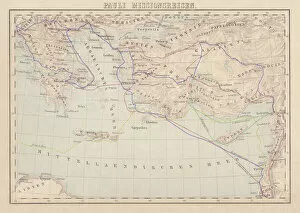
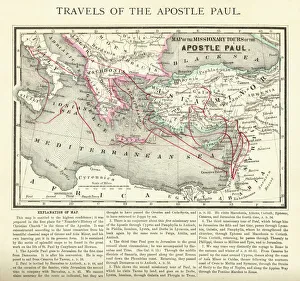
Apostle Pauls Missionary Journeys, lithograph, published in 1886Apostle Pauls Missionary Journeys: 1st (green); 2nd (red); 3rd (blue); last to Rome (yellow). Lithograph, published in 1886. Paul travelled over 10, 000 miles proclaiming the gospel of Jesus Christ
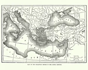
Map of the Byzantine Empire in the 9th CenturyVintage engraving of a Map of the Byzantine Empire in the 9th Century
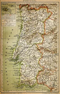
Map of PortugalAntique illustration engraving map og Portugal
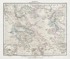
Greece at the beginning of the Peloponnesian War (431-404 BC)Antique Map of Greece at the beginning of the Peloponnesian War (431 - 404 BC) with the different tribal groups. Steel engraving with hand colored borderlines, published in 1861
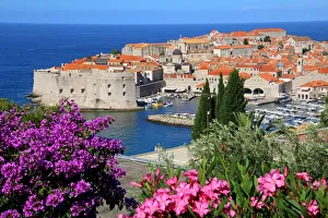
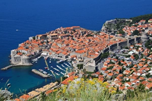
View of Old Town City of DubrovnikDubrovnik is one of the most prominent tourist destinations in the Mediterranean Sea, a seaport on the Dalmation coast. In 1979, the city of Dubrovnik joined the UNESCO list of World Heritage Sites
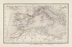
Roman Republic and Carthage during the Second Punic War (218-201-BC)Ancient map of the Roman Republic and Carthage during the Second Punic War (218 to 201 BC). Legend in Latin language. Steel engraving with hand colored borderlines, published in 1861
Elevated view of famous shipwreck beach. Zakynthos, Greek Islands, Greece
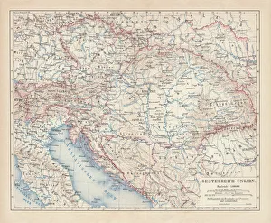
Austro-Hungarian Empire, Habsburg Monarchy, lithograph, published in 1877Ancient map of Austro-Hungarian Empire. Habsburg Monarchy. Lithograph, published in 1877
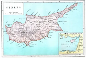
Map of CyprusVintage 19th Century map of Cyprus in the eastern Mediterranean Sea
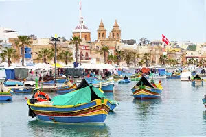
Maltese Fishing BoatsTypical Maltese boats moored in the fishermen village Marsaxlokk on the Malta island
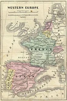
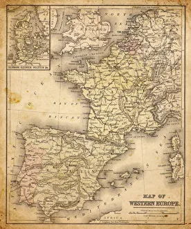
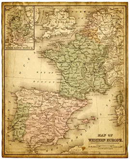
France Spain Portugal map 1856Colton and Fitchs Modern School Geography by George W. Fitch - New York 1856
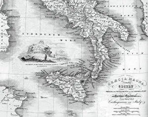
Vintage map of Magna Graecia, showing the settlements of the ancient greeks in Italy. Magna GrA|cia is the name of the coastal areas of Southern Italy on the Tarentine Gulf that was extensively
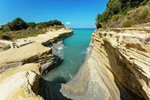
Canal D Amour beach near Sidari, Corfu, Greece
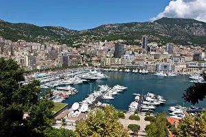
Overlooking the harbour of Monaco, Port Hercule, Monte Carlo, Principality of Monaco, Cote dAzur, Mediterranean Sea, Europe, PublicGround
View of Oludeniz, TurkeyTo get this view you take the Lycian Way which is a pathway behind the Montana Pine Resort in OluDeniz in Turkey. It takes about 30 minutes
Travels of The Apostle Paul Map EngravingEngraved illustration of the Travels of The Apostle Paul Map Engraving from The Popular Pictorial Bible, Containing the Old and New Testaments, Published in 1862
St Pauls BayA lookout point over Saint Pauls Bay overs a fantastic view of the bay and the Lindos acropolis. The citadel was fortified successively by the Greeks, the Romans, the Byzantines
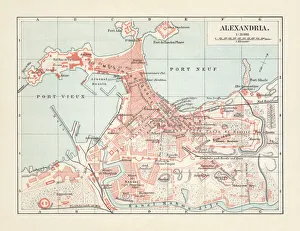
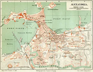
City map of Alexandria, Egypt, lithograph, published in 1897City map of Alexandria, Egypt. Lithograph, published in 1897
Dawn over famous village of Oia, Santorini, GreeceSunrise over the village of Oia, with famous whitewashed buildings and blue domed churches. Santorini, Mediterranean sea, Greece
Blue sea in summer, greek islands, Santorini
Beauty of Positano, Amalfi Coast, ItalyBeautiful Positano, with the beach and ships in the mediterranean sea at summer in Amalfi Coast, Italy
Positano, italy. Amalfi CoastHigh view of Positano, italy. Amalfi Coast. Costa Amalfitana
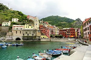
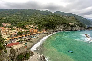
Cinque Terre coastline villages, La Spezia, ItalyFacing the mediterranean sea, Cinque Terre (meaning Five lands ) coastline villages, La Spezia, Italy. This is a high view of colorful Vernazza, the other are Monterosso al Mare, Manarola
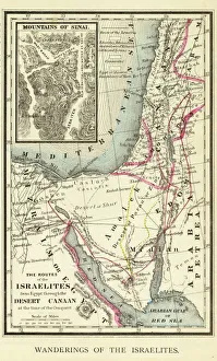
Wanderings of the Israelites Map EngravingEngraved illustration of Wanderings of the Israelites Map Engraving from The Popular Pictorial Bible, Containing the Old and New Testaments, Published in 1862. Copyright has expired on this artwork
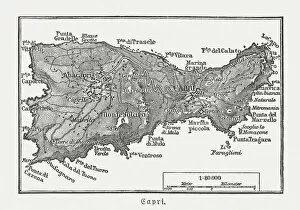
Map of Capri, Italian island, wood engraving published in 1897Map of Capri, Italian island. Wood engraving, published in 1897
Monterosso al Mare panoramic view in a cloudy day. Unesco World heritage site
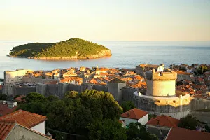
View of Old Town, the walled city of Dubrovnik, UNESCO World Heritage Site, Dalmatia, CroatiaDubrovnik is one of the most prominent tourist destinations in the Mediterranean Sea, a seaport on the Dalmation coast. In 1979, the city of Dubrovnik joined the UNESCO list of World Heritage Sites
Plan of the old city Alexandria 1895Meyers Konversations-Lexikon. Ein Nachschlagewerk des allgemeinen Wissens, 5th edition 17 volumes Bibliographisches Institut - Leipzig 1895-1897
old map of european old map form 1883, showing european countries
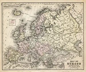
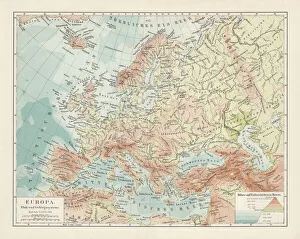
Topographic map of Europe, lithograph, published in 1897Topographic map of Europe. Lithograph, published in 1897
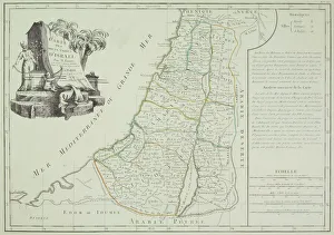
Historical map of Palestine with the twelve tribes of Israel. Colored steel engraving, published in 1886
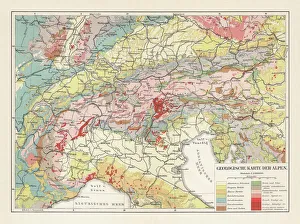
Geological map of the European Alps, lithograph, published in 1897Geological map of the European Alps. Lithograph, published in 1897
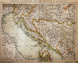
Bosnia, dalmatia, istria, croatia, slavoniaAntique illustration of a Bosnia, dalmatia, istria, croatia, slavonia map
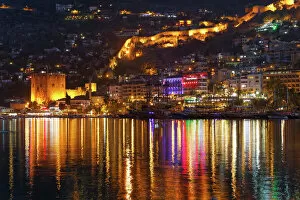
Kizil Kule, Red Tower, with the ramparts and the harbour, Alanya, Turkish Riviera, Province of Antalya, Mediterranean Region, Turkey
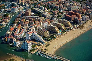
Aerial view, high-rise buildings, holiday resort on the beach, Roses, Golf de Roses, Catalonia, Spain
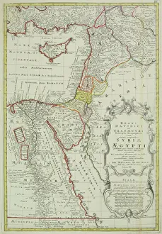
Antique map of the Middle East with Egypt, Syria, and Israel. Date unknown
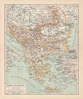
Balkan Peninsula in 1878, lithographAncient map Balkan. The political classification of the Balkan Peninsula after the Treaty of Berlin in 1878. Lithograph, published in 1878
Antique map of Israel
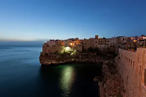
View of Polignano a Mare in the morning, Puglia region, also known as Apulia, Southern Italy, Italy, Europe
Walled City of Dubrovnik, Southeastern Tip of Croatia, Dalmation Coast, Adriatic Sea, Croatia, Eastern Europe
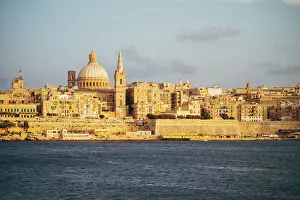
View of Valletta city (Malta) from the bay in Sliema. Warm light, sunset
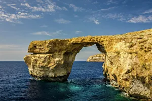
Azure Window, Dwejra Point, Gozo, MaltaThe Azure Window is a natural arch in the Maltese island of Gozo. The stunning geography of the area was created thousands of years ago when two limestone caves collapsed
western europe map 1883a map of Western europe from 1883
western europe 1867a map of Western europe from 1867, overlay with grunge burnt texture paper
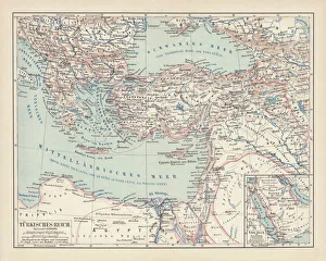
Ottoman Empire, lithograph, published in 1878Ancient map of Ottoman Empire. Lithograph, published in 1878
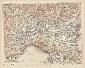
Ancient map of Northern Italy, lithograph, published in 1876Ancient map of Northern Italy. Lithograph, published in 1876