mail_outline sales@mediastorehouse.com
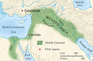
Digital illustration of the fertile crescent of Mesopotamia and Egypt and location of first towns
Iconic blue domed church in Oia Santorini GreeceIconic blue domed church overlooking mediterranean sea. Oia Santorini Greece
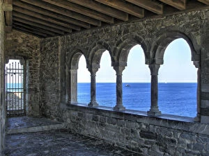
View through the romanesque loggia of St. Peter church in Porto Venere, ItalyThe Church of St. Peter is a Roman Catholic church in Lazzaro Spallanzani, Portovenere, Italy, in the Gulf of Poets in the province of La Spezia. It was officially consecrated in 1198
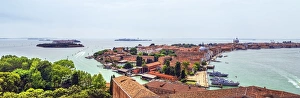
Panorama Of Venice Or Venezia, ItalyElevated view of Venice from San Giorgio Maggiore bel tower. On the right side is Grand Canal
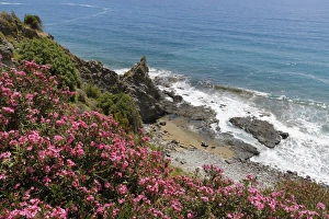
Flowering oleander -Nerium oleander- on the coast, Turkish Riviera, Alanya, Antalya province, Cilicia, Turkey
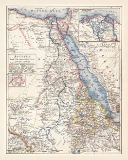
Map of Egypt, Darfur, and Abyssinia, lithograph, published in 1897Map of Egypt, Darfur, and Abyssinia with separate map of the Nile Delta and Suez Canal. Lithograph, published in 1897
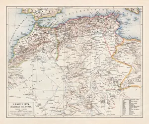
North Africa: Algeria, Morocco and Tunisia, lithograph, published in 1897Topographic map of Algeria, Morocco and Tunisia with the borders at the end of the 19th century. Lithograph, published in 1897
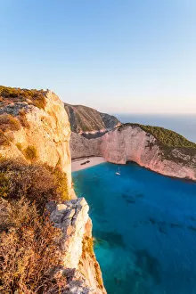
Sunset on famous Navagio shipwreck beach, Zakynthos, GreeceColourful sunset over famous shipwreck beach. Zakynthos, Greek Islands, Greece
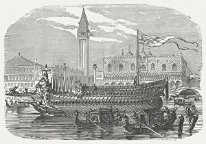
Bucentaur - Galley of the doges of Venice, built 1728Bucentaur, the state galley of the doges of Venice. Built 1728, and destroyed by soldiers of Napoleon Bonaparte in 1798. Wood engraving, published in 1880
Mediterranean moray (Muraena helena)Illustration of a Mediterranean moray (Muraena helena)
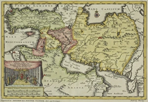
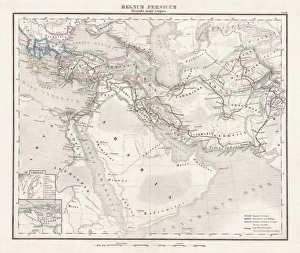
Antique map of Persia and the Middle East
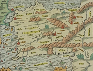
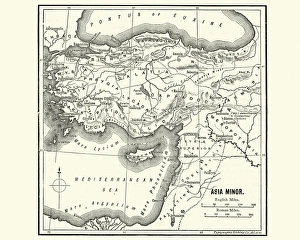
Antique map of Asia Minor, present day Turkey
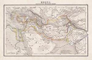
Empire of Alexander the Great, hand-coloured steel engraving, published 1861Antique map from Empire of Alexander the Great 356 - 326 BC) after the battle of Ipsos (301 BC). Legend in Latin language. Steel engraving with hand colored borderlines, published in 1861
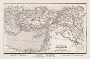
Seleucid Empire, 3rd to 2nd century BC, published in 1861The Seleucid Empire was created after the death of Alexander the Great and dominated the Near East from the 3rd to 2nd century BC. Legend in Latin language
Persian Empire (c. 400 BC), steel engraving, pubolished in 1861Antique map from the Persian Empire (around 400 BC) before the conquest of Alexander the Great (334/335 BC). Legend in Latin language. Steel engraving with hand colored borderlines, published in 1861
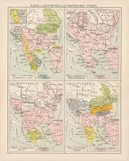
Ottoman Empire, 14th-19th century, lithograph, published in 1878Ancient map of the history of European Turkey, 15th - 19th century. Lithograph, published in 1878
Map of Asia Minor in Ancient TimesVintage engraving of a Map of Asia Minor in Ancient Times
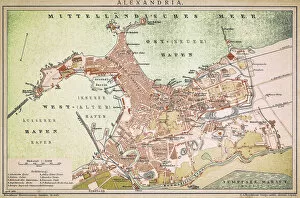
Alexandria mapAntique illustration of a Mediterranean Sea
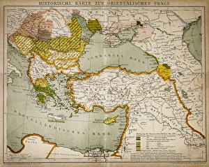
Historical map of the Oriental part of worldAntique illustration of a Historical map of the Oriental part of world
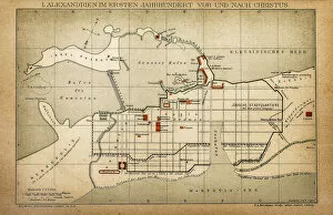
Alexandria in the first century before and after ChristAntique illustration of a Alexandria in the first century before and after Christ
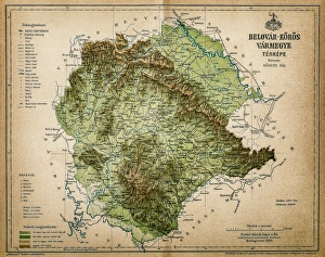
Belovar-koros, Croatio map from 1893Antique illustration of a Belovar-koros, Croatio map from 1893
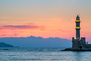
Romantic ChaniaA couple enjoys the romantic setting of the Chania Lighthouse in Crete. Chania Venetian harbour with its lighthouse is the most important site in city of Chania, Crete
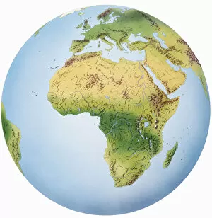
Globe of Earth showing African continent, Europe, Middle East, and parts of Asia
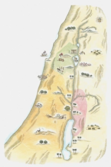
Illustration of map of Judea, the area in which Jerusalem was situated, as it would have been at the time of Jesus
Blue domed church and sea, Santorini, GreeceIconic orthodox church overlooking the mediterannean sea, in summer. Oia, Santorini, Aegean islands, Greece
Famous orthodox church at sunset Santorini, GreeceFamous white and yellow orthodox church at sunset, Santorini, Cyclades islands, Mediterranean sea, Greece
Blue domed church in Oia, Santorini, GreeceBlue domed church in Oia, overlooking the mediterranean sea at sunrise. Santorini, Greece
Famous church and cruise ship, Santorini, GreeceFamous yellow church at sunset, overlooking the mediterranean sea with cruise ship, near the volcano Nea Kameni. Santorini, Aegean islands, Mediterranean sea, Greece
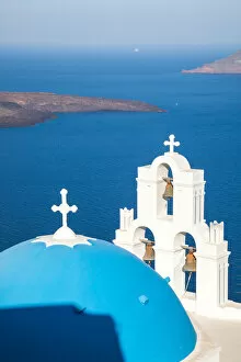
Iconic blue cupola over the sea Santorini GreeceIconic greek blue cupola and bell tower, overlooking mediterranean sea, with volcano island Nea Kameni on the left. Firostefani, Santorini, Greece
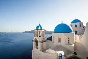
Iconic blue domed churches in SantoriniIconic blue domed churches overlooking mediterranean sea, in the village of Oia, Santorini, Greece
Blue and white churches in Santorini GreeceTraditional orthodox blue and white churches overlooking the mediterranean sea, at sunset. Oia, Santorini, Greece
Summer in the island of Santorini, Mediterranean sea, GreeceBeautiful town of Oia with typical blue domed orthodox churches, Santorini island, Aegean islands, Mediterranean, Greece
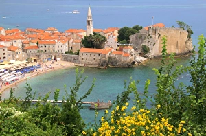
Stari Grad (Old Town) and beach of Budva, MontenegroThe coastal area around Budva, called the Budva riviera, is the center of Montenegrin tourism, known for its well-preserved medieval walled city, sandy beaches and diverse nightlife
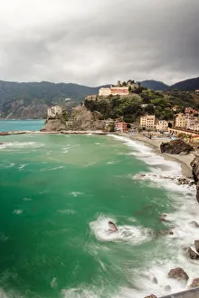
Monterosso al Mare coastline, Cinque Terre, ItalyMonterosso al Mare coastline in Cinque Terre, Italy. It is one of the main five towns all part of the Cinque Terre National Park and is a UNESCO World Heritage Site, the other are Vernazza
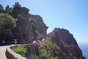
Road through the Calanques of Piana, Corsica, FranceA view on a part of the Calanques or Calanches of Piana, located near Piana, Corsica, France. The Calanques are part of the Unesco World Heritage Site and consist of Calaches in a mountain area
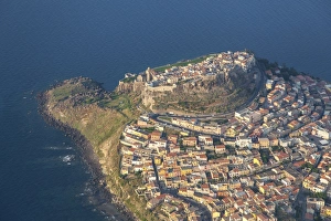
Aerial view of Castelsardo, Sardinia, Italy
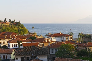
View over the old town, Kaleici, Antalya, Antalya Province, Turkey
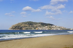
Keykobat beach with the hill of Alanya Castle and the town of Alanya, Alanya, Turkish Riviera, Province of Antalya, Mediterranean Region, Turkey
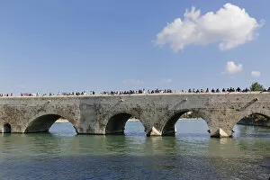
Old stone bridge, Taskopru, Seyhan River, Adana, Cukurova, Mediterranean, Turkey
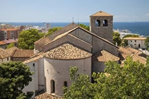
Trieste Cathedral, Trieste, Friuli-Venezia Giulia, Italy
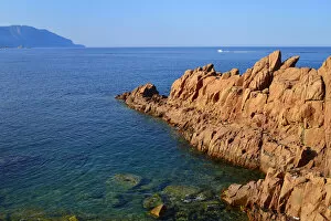
The red rocks of Arbatax, porphyry rocks, Tortoli, Province of Ogliastra, Sardinia, Italy
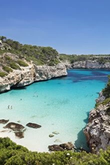
Bay and beach of Cala d es Moro in Calas Almonia, Santanyi, Majorca, Balearic Islands, Spain
Skyline of BarcelonaView over Barcelona showing UNESCO world heritage Site Sagrada FamAilia and oval shaped skyscraper Torre Agbar, towering over Poblenou neighbourhood, Mediterranean sea is also visible in background
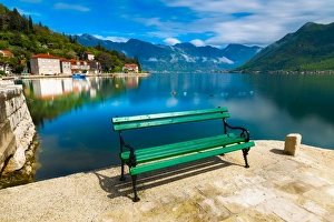
Bench in Perast, Kotor Bay, Montenegro
antiquity, archival, argonauts, cartography, europe, geographical, geography, historical, map, mediterranean sea, nobody, old-fashioned, text, vintage, Antique Maps, 89703922
Map of Athens and surroundings, lithograph, published in 1897Map of Athens and surroundings, Greece. Lithograph, published in 1897
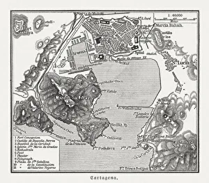
City map of Cartagena, Murcia, Spain, wood engraving, published 1897City map of Cartagena, Murcia, Spain. Wood engraving, published in 1897