mail_outline sales@mediastorehouse.com
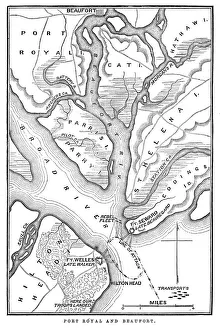
Battle of Port RoyalVintage engraving from 1863 of a map of the Battle of Port Royal which was one of the earliest amphibious operations of the American Civil War
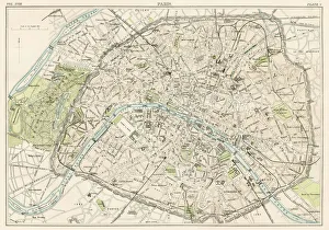
Paris city map 1885Encyclopedia Britannica 9th Edition New York Charles Scribners and Sons 1885 Vol XVIII
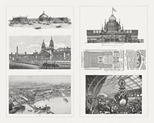
Buildings of the world Exhibitions, 19th centuryExhibition buildings of world exhibitions in the 19th century: 1-3) Buildings for the World Exhibition 1893 in Chicago, USA: 1) Machine exhibition building, 2) Building for horticulture
Fungi, Mushrooms, Algae and Non-Flowering PlantsEngraved illustrations of Representatives of the Algae, Fungi, Bryophyta, Polypodiophyta and other Non-Flowering Plants from Iconographic Encyclopedia of Science, Literature and Art
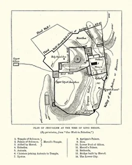
Plan of Jerusalem at the Tine of King HerodVintage engraving of a Plan of Jerusalem at the Tine of King Herod
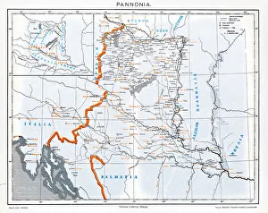
Pannonia is an ancient country of southern Europe that was south and west of the Danube River, in present-day Austria, Hungary, Slovenia, and Croatia
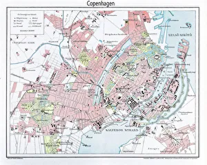
Engraving: Map of Copenhagen from 1895illustration of a Engraving: Map of Copenhagen from 1895
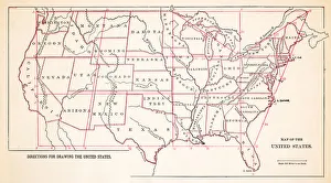
Map of United States 1883Warrens Common School Geography
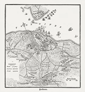
Battle of Yorktown in 1781, wood engraving, published in 1884Plan of the Battle of Yorktown during the American Revolutionary War in 1781. Wood engraving, published in 1884
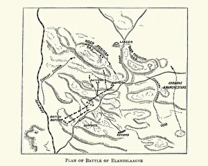
Second Boer War - Plan of the Battle of ElandslaagteVintage engraving of The Battle of Elandslaagte was a battle of the Second Boer War, and one of the few clear-cut tactical victories won by the British during that conflict
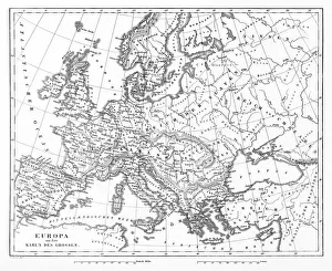
Victorian Map of EuropeEngraved illustrations of Europe in the Time of Charlemagne from Iconographic Encyclopedia of Science, Literature and Art, Published in 1851. Copyright has expired on this artwork. Digitally restored
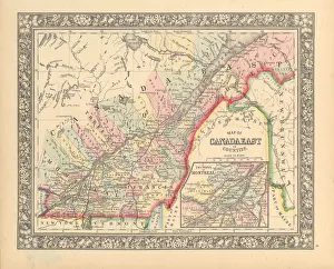
Victorian Map of Eastern Canada Circa 1850Engraved illustration of a Map of Eastern Canada in counties from Iconographic Encyclopedia of Science, Literature and Art, Published in 1851. Copyright has expired on this artwork. Digitally restored
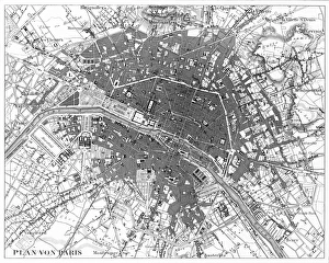
Paris, France Circa 1850 EngravingEngraved illustrations of the City of Paris from Iconographic Encyclopedia of Science, Literature and Art, Published in 1851. Copyright has expired on this artwork. Digitally restored
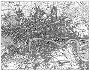
London, England Circa 1850 EngravingEngraved illustrations of the city of London, England from Iconographic Encyclopedia of Science, Literature and Art, Published in 1851. Copyright has expired on this artwork. Digitally restored
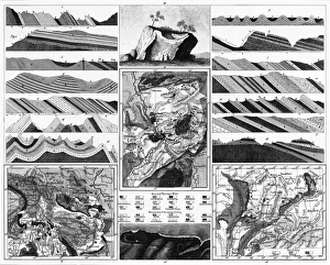
Special Geology EngravingEngraved Illustrations of Special Geology Engraving from Iconographic Encyclopedia of Science, Literature and Art, Published in 1851. Copyright has expired on this artwork. Digitally restored
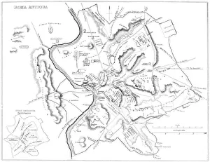
Map of Ancient RomeVintage engraving showing a plan of Ancient Rome
Antique print of plans for town of Isfahan in Iran
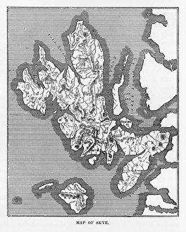
Map of the Isle of Skye, Scotland Victorian Engraving, 1840Very Rare, Beautifully Illustrated Antique Engraving of Map of the Isle of Skye, Scotland Victorian Engraving, 1840. Source: Original edition from my own archives
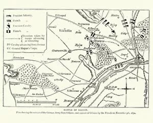
Franco Prussian War Plan of the Battle of CoulmiersVintage engraving of a scene from the Franco Prussian War. Plan of the Battle of Coulmiers (Baccon), The Battle of Coulmiers was fought on November 9
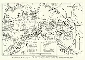
Franco Prussian War Battle plan of Siege of OrleansVintage engraving of a scene from the Franco Prussian War. Battle plan of Siege of Orleans
PineconeIllustration of a pine cone isolated on white
Draftsman working at desk in office, elavated view
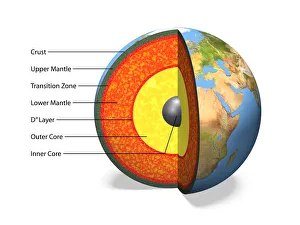
Internal structure of the Earthwith English labels, 3D illustration
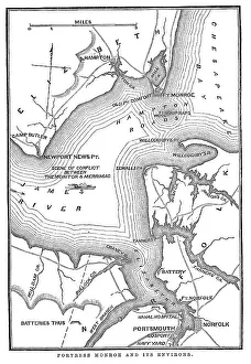
Fort Monroe and its environsVintage engraving from 1863 of a map of Fort Monroe and its environs. Fort Monroe played an important role in the American Civil War
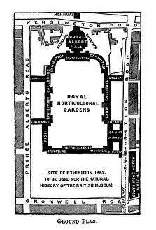
Map of Kensington museums area, LondonA rough sketch map of the area used for the then Royal Horticultural Gardens and museums in the Kensington area, London, including the proposed Natural History Museum
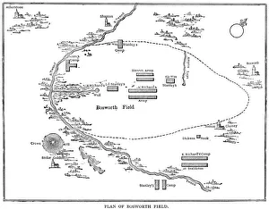
Battle of Bosworth FieldVintage engraving showing a plan of the Battle of Bosworth Field. The Battle of Bosworth (or Bosworth Field) was the last significant battle of the Wars of the Roses
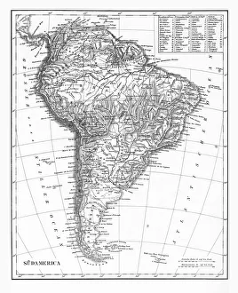
The Continent of South America, Circa 1850Engraved illustrations of the Map of South America from Iconographic Encyclopedia of Science, Literature and Art, Published in 1851. Copyright has expired on this artwork. Digitally restored
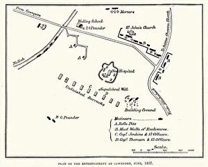
Plan of the Entrenchment at Cawnpore, June, 1857, during the Indian Rebellion of 1857
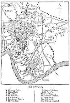
Crakow city plan 1884Encyclopedia Britannica 9th Edition New York Charles Scribners and Sons 1884 Vol VI
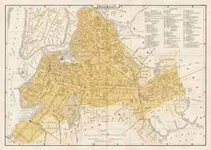
Broklyn city map 1893Johnsonas Universal Cyclopedia - Charles Kendall - New York 1893
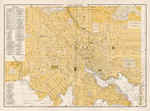
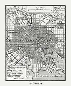
Baltimore city map 1893Johnsonas Universal Cyclopedia - Charles Kendall - New York 1893
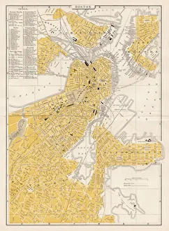
Boston city map 1893Johnsonas Universal Cyclopedia - Charles Kendall - New York 1893
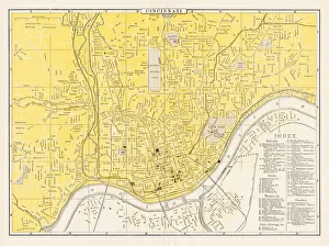
Cincinnati map 1893Johnsonas Universal Cyclopedia - Charles Kendall - New York 1893 vol 2
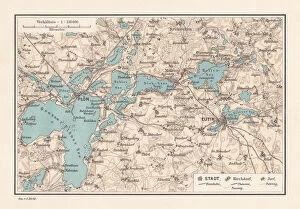
PlAon, district seat in Schleswig-Holstein, Germany, lithograph, published in 1887Map of PlAon, district seat in Schleswig-Holstein, Germany. It lies on the shores of Schleswig-Holsteins biggest lake. Lithograph, published in 1887
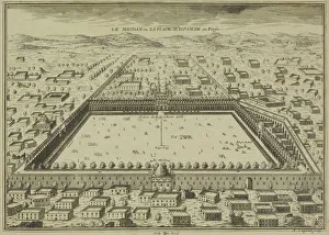
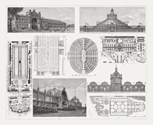
Exhibition buildings to world exhibitions in the 19th centuryExhibition buildings and floor plans of world exhibitions in the 19th century: 1) Paris 1855, Industry building; 2) Paris 1855, detail from the floor plan; 3) Paris 1867, floor plan; 4) Vienna 1873
City map of Baltimore, Maryland, USA, wood engraving, published in 1897City map of Baltimore, Maryland, USA. Wood engraving, published in 1897
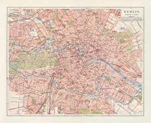
City map of Berlin, Germany, lithograph, published in 1897City map of Berlin, capital of Germany. Lithograph, published in 1897
Antique illustration of mediterranean landscapes: Saint Pauls Chapel, MaltaAntique illustration of mediterranean landscapes: Saint Pauls Chapel, Valley of Mousta, Malta
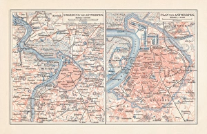
City map of Antwerp and surrounding, Belgium, lithograph, published 1897City map of Antwerp and surrounding, Belgium. Lithograph, published in 1897
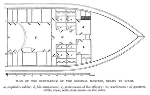
Plan of berth deck of the original monitor warship - 1886 scanned engraving
360 Aerial View of Bangli Regency, Bali, IndonesiaThis is a panoramic 360 view above the scenic rural landscapes in Bangli Regency, Bali
360 Aerial Little of Balis Scenic Rural LandscapesThis photo was captured in Gianyar Regency of Bali, Indonesia. Enjoy the bird s-eye view above these scenic rural landcapes
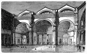
Frigidarium of the Baths of the Caracalla at RomeIllustration of a Frigidarium of the Baths of the Caracalla at Rome
Tepidarium of the thermal baths excavated in 1824 to PompeiiIllustration of a Tepidarium of the thermal baths excavated in 1824 to Pompeii
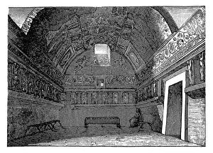
Bathroom of the Fugger in AugsburgIllustration of bathroom of the Fugger in Augsburg
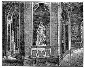
Marble bathroomIllustration of a Marble bathroom
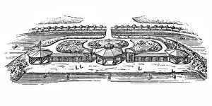
Sol baths in DonaueschingenIllustration of a sol baths in Donaueschingen
Bathing establishmentIllustration of Bathing establishment