mail_outline sales@mediastorehouse.com
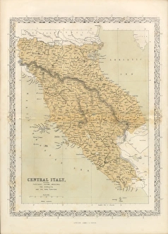
Victorian Map of Central Italy, Circa 1865Extremely Rare, Beautifully Illustrated Antique Victorian Engraved Illustration of the map of Central Italy including Tuscany, Parma and Modena from Liberators of Italy
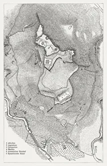
Acropolis of Pergamon, published in 1881Map of the Acropolis of Pergamon (Unesco World Heritage Site). Wood engraving, published in 1881
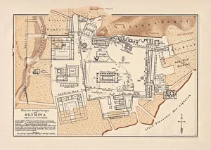
Excavations of Olympia, lithograph, published in 1880Old map of the plan of the excavations of Olympia. Lithograph, published in 1880
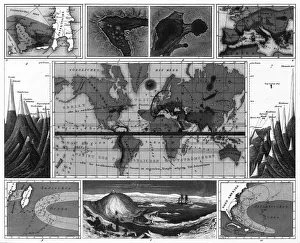
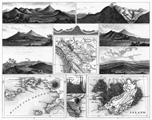
Volcanic and Hurricane Charts; Craters; and Antarctica EngravingEngraved Illustrations of Volcanic and Hurricane Charts; Craters; and Antarctica from Iconographic Encyclopedia of Science, Literature and Art, Published in 1851
Volcanoes and Volcanic Formations and Stratification EngravingEngraved Illustrations of Volcanoes and Volcanic Formations and Stratification from Iconographic Encyclopedia of Science, Literature and Art, Published in 1851. Copyright has expired on this artwork
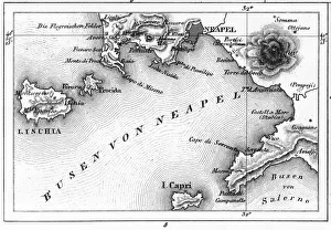
Map of Bay of Naples and Naples EngravingEngraved Illustrations of Volcanoes and Volcanic Formations and Stratification and the Map of Bay of Naples and Naples, Italy from Iconographic Encyclopedia of Science, Literature and Art
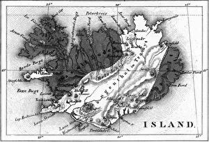
Map of Volcanic Chart of Iceland EngravingEngraved Illustrations of Volcanoes and Volcanic Formations and Stratification and the Map of Volcanic Chart of Iceland from Iconographic Encyclopedia of Science, Literature and Art
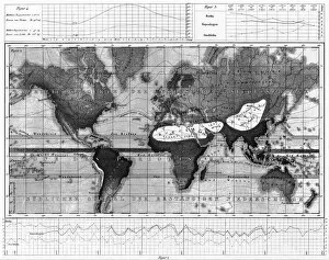
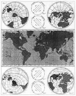
Historical Rainfall and Temperature Charts EngravingEngraved Illustrations of Historical Rainfall and Temperature Map; Temperature Charts of the World from Iconographic Encyclopedia of Science, Literature and Art, Published in 1851
Climate and Weather Charts EngravingEngraved Illustrations of Climate and Weather Charts of the World from Iconographic Encyclopedia of Science, Literature and Art, Published in 1851. Copyright has expired on this artwork
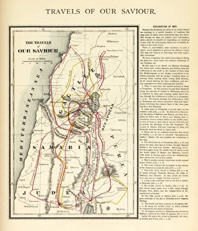
Travels of Our Savior Map EngravingEngraved illustration of the Travels of Our Savior Map Engraving from The Popular Pictorial Bible, Containing the Old and New Testaments, Published in 1862. Copyright has expired on this artwork
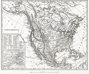
North America 1850 EngravingEngraved illustrations of the Physical Map of North America from Iconographic Encyclopedia of Science, Literature and Art, Published in 1851. Copyright has expired on this artwork. Digitally restored
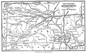
Missouri CampaignsVintage engraving from 1863 of a map of the Missouri Campaigns from the time of the American Civil War
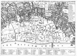
London after the Great FirePlan of London of the Great fire of 1666 showing which parts had been burnt down. The Great Fire of London was a major conflagration that swept through the central parts of the English city of
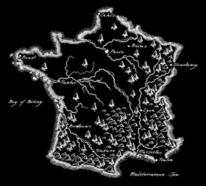
Antique France MapFrance Map, - Antique style. Includes mountains and water bodies. High detail - vector illustration
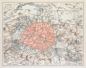
Map of Paris 1895map/plan of the city of Paris, France 1895
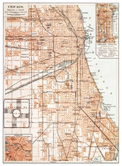
Map of Chicago 1895Map of the city of Chicago, USA
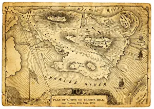
Plan of action at the Battle on Breeds HillVintage engraving of the Plan of action at the Battle of Breeds Hill (also known as the Battle of Bunker Hill), Near Boston on 17th June 1775. Part of the American War of IndependenceView more:
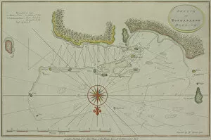
Antique map of Tongataboo in the South Pacific
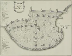
Antique map of fortified city of Ptolemaida
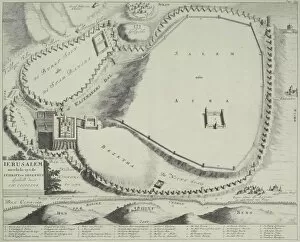
Antique plan of Jerusalem, Israel
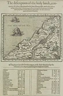
Antique map of the holy land with table of data
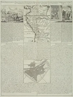
Antique map of Peru and Ecuador with plans for Lima
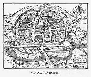
Old Plan of Exeter in Devon, England Victorian Engraving, 1840Very Rare, Beautifully Illustrated Antique Engraving of Old Plan of Exeter in Devon, England Victorian Engraving, 1840. Source: Original edition from my own archives
Plan of Leeds (Victorian engraving)A 19th century plan of Leeds in Yorkshire, England. From Our Own Country: Descriptive, Historical, Pictoriala published by Cassell & Co Ltd, 1885
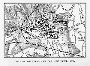
Map of Coventry in Warwickshire, England Victorian Engraving, 1840Very Rare, Beautifully Illustrated Antique Engraving of Map of Coventry in Warwickshire, England Victorian Engraving, 1840. Source: Original edition from my own archives
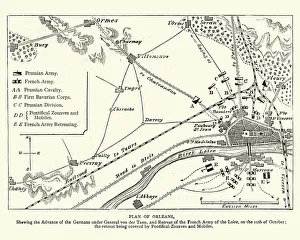
Franco Prussian War - Plan of Second Battle of OrleansVintage engraving of a scene from the Franco Prussian War. Plan of the Second Battle of Orleans, 1870
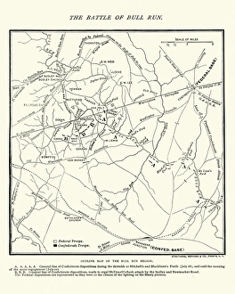
Map of the Battle of Bull RunVintage engraving of a Map of the Battle of Bull Run, The Century Magazine, 1884
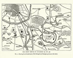
Franco Prussian War Battle plan of Siege of ParisVintage engraving of a scene from the Franco Prussian War. Battle plan of Siege of Paris
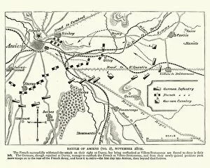
Franco Prussian War plan of the Battle of AmiensVintage engraving of a scene from the Franco Prussian War. plan of the Battle of Amiens
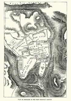
Plan of Jerusalem in the 1st CenturyVintage engraving of a Plan of Jerusalem in the 1st Century
CranksetAntique illustration bicycle cranks on a white background
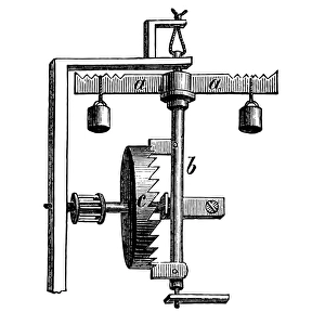
Verge escapementAntique illustration of a watch verge escapement mechanism
Cylinder escapementAntique illustration of Cylinder escapement
Steam locomotive, vintage engravingAntique illustration of the first locomotive Eagle on German soil
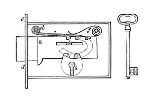
Diagram of a lock and keyAntique illustration of lock and key
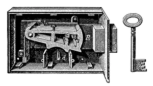
lock and keyAntique illustration of lock and key
Trevithicks locomotiveAntique illustration of the Trevithicks locomotive
Atlantic locomotiveAntique illustration of the Atlantic locomotive
Oscillating Steam EngineAntique illustration of a Oscillating Steam Engine
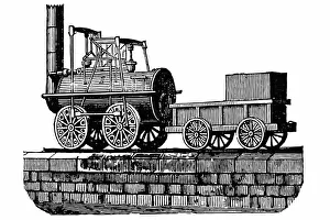
Stephensons locomotiveAntique illustration of a Stephensons locomotive
Spanish ArtichokeCardy, vegetables artichoke, cardoon, cardoon, Kardy, Spanish Artichoke
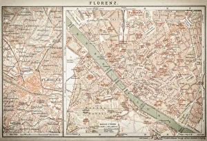
map of florenceEngraved illustrations of the City of Florence
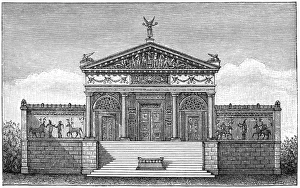
Etruscan templeAntique illustration of a Etruscan temple
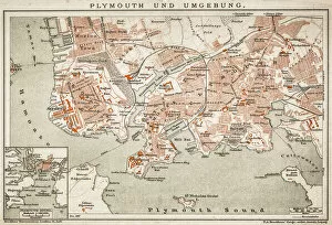
Plymouth and the surrounding area
Cornish engineAntique illustration of a Cornish engine - steam engine
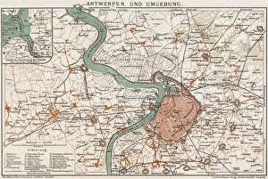
Antwerp and environmentAntique illustration of a Map of Antwerp
Asparagus (Asparagus officinalis)Illustration of a Asparagus (Asparagus officinalis)
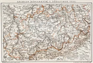
Saxony kingdom mapAntique illusytration of a Saxony kingdom map