mail_outline sales@mediastorehouse.com
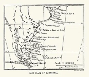
Antique Map of the East Coast of Patagonia in the 16th Century
Vintage photo frame 1900Photo Greeting Card 1900 s
Pocahontas (c. 1596-1617), Native American, wood engraving, published in 1884Pocahontas (born Matoaka, known as Amonute, and later known as Rebecca Rolfe, c. 1596 - 1617), Native American. She was an intermediary between the trunks of the Virginia Algonquian
Native American of CaliforniaVintage engraving showing a Native American of California, 1873
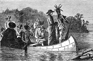
Marquette and Joliet discovering the Mississippi
Edgar Allan Poe January 19, 1809 - October 7, 1849) was an American author, poet, editor, and literary critic, considered part of the American Romantic Movement
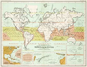
Winds - Map of the world 1861Map of the world - Winds over the globe - storms and hurricanes
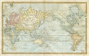
the world 1877antique map of the world - 1877
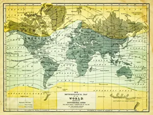
map of the world 1867meteorological map of the world 1867 - showing isothermal lines
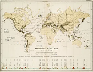
Map of the world 1861Map of the world - The distribution of Earthquakes and Volcanoes over the globe
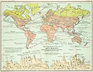
Animals - Map of the world 1861Map of the world - The distributions of animals
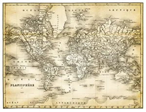
map of the world 1873antique map of the world - from a french atlas - 1872
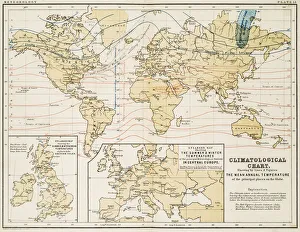
Climate map of the world 1861Map of the world - Climatological Chart
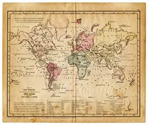
map of the world 1855map of the world illustrating the principal features of the land and the co-tidal lines - 1855
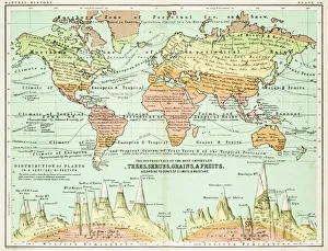
Agricultural Map of the world 1861map of the world showing the distribution of the most important Tress, Shrubs, Grains and Fruits according to zones of climate and moisture plants
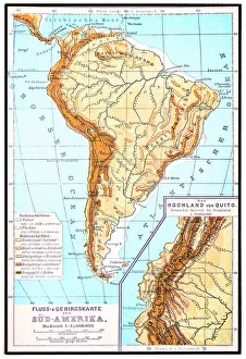
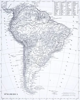
South America, river and mountains mapIllustrator of a South America, river and mountains map
Benjamin franklin (XXXL)Portrait of Benjamin Franklin, engraved by
Toddlers In Field Of Daisies. They Wear Fancy Clothes Dress And SuitUNITED STATES - CIRCA 1950s: Toddlers In Field Of Daisies. They Wear Fancy Clothes Dress And Suit. The Girl Holds Daisy Bouquet While The Boy Pulls Daisy Petals For Loves Me Not Game
Baltimore oriole (Icterus galbula), lithograph, published in 1882Baltimore oriole (Icterus galbula). Lithograph, published in 1882
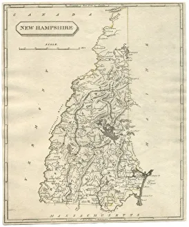
Antique map of New Hampshire USA 19th century 1819This is a copperplate engraving, a 19th century map of New Hampshire in the United States of America, with hand-coloured borders with Canada, Maine, Massachusetts and Vermont
Engraving: Map of North AmericaEngraved illustrations of the Theory of the Art of Drawing from Iconographic Encyclopedia of Science, Literature and Art, Published in 1851. Copyright has expired on this artwork. Digitally restored
Engraving: South AmericaEngraved illustrations of South America from Iconographic Encyclopedia of Science, Literature and Art, Published in 1851. Copyright has expired on this artwork. Digitally restored
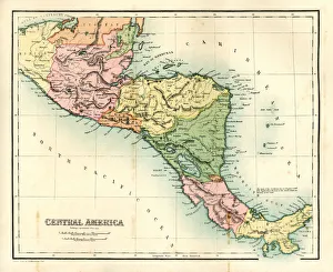
Antique map - Central AmericaAntique map of Central America, 1864
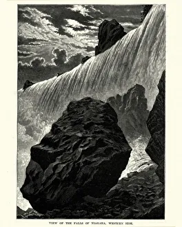
Niagara Falls, American side, New York, USA, published in 1880Niagara Falls, American side, New York, USA. Wood engraving, published in 1880
Niagara Falls, 19th CenturyVintage engraving of Niagara Falls, 19th Century
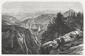
Yosemite National Park, USA, wood engraving, published in 1872Yosemite National Park, California, USA. Wood engraving, published in 1872
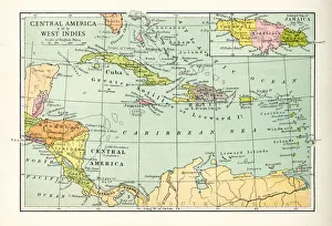
Antique Map of Central America and West IndesVintage map of Central America and West Indes, from 1894
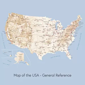
Map of the USA general referenceVector illustration of a map of the United States of America. The reference map used in the creation of this illustration is public domain map available at the University of Texas website: http
Map of United States with Watercolor Texture - Raster IllustrationAn abstract map of the United States with a multicoloured, rainbow hand painted watercolor texture. Map is isolated on a white background. Raster illustration
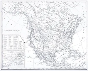
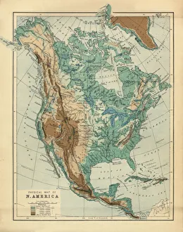
North America Physical Map, Engraving, 1892Very rare, beautifully detailed engraving of North America Physical Map, Engraving, Published in 1892. Original edition from my own archives. Copyright has expired on this artwork. Digitally restored
Cuts of lamb or mutton diagramPoster with detailed diagram cutting lamb
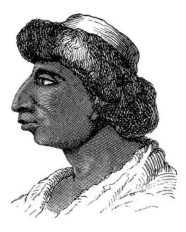
American NativeAntique illustration of a American Native
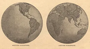
Old, Map of Eastern and Western Hemispheres, From 1875Old black and white illustration of the Eastern Hemisphere and the Western Hemisphere, from the 1800 s
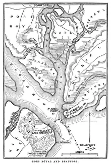
Battle of Port RoyalVintage engraving from 1863 of a map of the Battle of Port Royal which was one of the earliest amphibious operations of the American Civil War
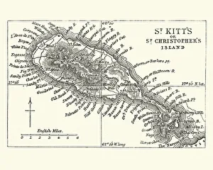
Map of Saint Kitts, 19th CenturyVintage engraving of a Map of Saint Kitts, 19th Century. Saint Kitts and Nevis, also known as the Federation of Saint Christopher and Nevis, [4] is an island country in the West Indies
animal behaviour, perching, physical stance, sitting, group of animals, flock of birdsLight-mantled albatross on a cliff top nest, on South Georgia Island in the Falklands
Aztec people, Mexican culture between the 14th-16th centuryIllustration of a Aztec people, Mexican culture between the 14th-16th century
Man standing in desert silhouetteMan silhouetted and walking below hills of the Nevada desert at sunsest
Map of New England by Explorer John Smith, Circa 1624Beautifully Illustrated Antique Engraved Victorian Illustration of Historical Map of New England from Explorer Captain John Smith, Circa 1624. Source: Original edition from my own archives
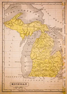
Michigan 1852 Map
Antquie Map of the United StatesVintage map of the United States of America from 1837
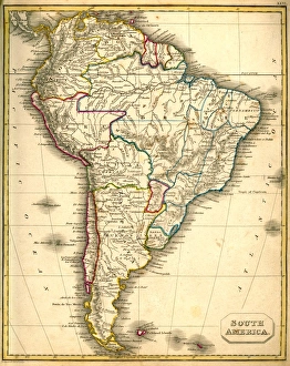
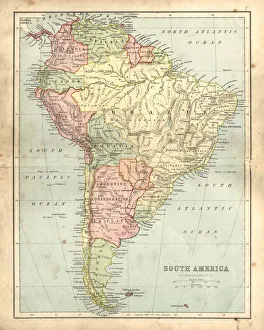
Antquie Map of South AmericaVintage map of South America from 1837
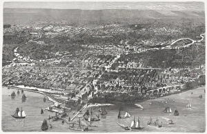
Chicago before the Great City Fire in 1871, published 1872Birds eye view of Chicago before the Great City Fire in 1871. Legend: 1) West-side, 2) Union-park, 3) Gasworks, 4) Lincoln-park, 5) Washington-place, 6) Promenade, 7) North-side, 8) Waterworks
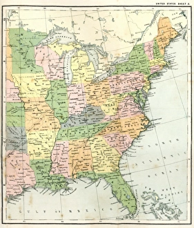
Antique Map of Eastern USAAntique Map from 1867 of Eastern United States of America
map of the world 1823map of the world - 1823 very detailed lithography
Antique damaged map of South America in the 19th CenturyVintage engraving of a Antique map of South America in the 19th Century, 1873
Toscanellis Map Of WorldToscanellis world map, showing Europe and India facing each other, omitting the Americas, 15th century. (Kean Collection/Getty Images)
Quitos Colonial Church and Monastery of Saint FrancisThe Church and convent of St. Francis is located in the South American capital city of Quito, Ecuador. This Roman Catholic church was constructed between the years 1550 and 1660